Grafik | Landkarte
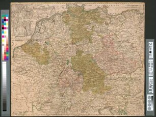
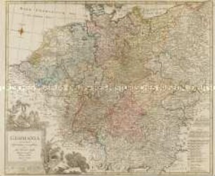
Imperii Romano-Germanici in suos status et circulos divisi tabula generalis
Historische Landkarte des heiligen Römischen ReichesDeutscher Nation mit Titelkartusche oben links mit Kaiser und Thron.
- Weitere Titel
-
L'Allemagne. In usus iuventutis erudiendae accomodata
- Sammlung
-
Pictothek
- Identifier
-
36/A 1.23
- Quelle
-
Universitätsbibliothek Würzburg
- Umfang
-
520 mm x 440 mm
- Sprache
-
Latein
Französisch
- Thema
-
Altkarte
- Bezug (wo)
-
Deutschland
- URN
-
urn:nbn:de:bvb:20-36a123term73544249-4
- Letzte Aktualisierung
-
06.03.2025, 15:26 MEZ
Datenpartner
Dieses Objekt wird bereitgestellt von:
Universitätsbibliothek Würzburg. Bei Fragen zum Objekt wenden Sie sich bitte an den Datenpartner.
Universitätsbibliothek Würzburg. Bei Fragen zum Objekt wenden Sie sich bitte an den Datenpartner.
Objekttyp
- Grafik
- Landkarte
Beteiligte
Entstanden
- Ca. 1720
Ähnliche Objekte (12)

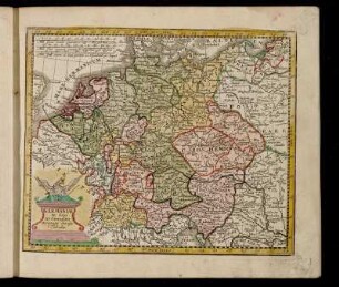
Imperii Romano-Germanici in suos status et circulos divisi
Imperii Romano-Germanici In Suos Status Et Circulos Divisi Tabula Generalis

Imperii Romano-germanici in suos status et circulos divisi. Tabula generalis in usus iuventutis erudiendae
![Imperii Romano-Germanici in Suos status et Circulos Divisi Tabula Generalis in UsusIuvenatis erudiendie accommodata [Atlas Germaniae specialis (Atlas Maior II), 1753]](https://iiif.deutsche-digitale-bibliothek.de/image/2/511f63ea-1fe4-49b7-9290-2efc45dfdd5a/full/!306,450/0/default.jpg)
Imperii Romano-Germanici in Suos status et Circulos Divisi Tabula Generalis in UsusIuvenatis erudiendie accommodata [Atlas Germaniae specialis (Atlas Maior II), 1753]
De S. Imperii Romano-Germanici Divisione In Decem Circulos
De S. Imperii Romano-Germanici Divisione In Decem Circulos

Mappa generalis Gubernii Asowiensis in Circulos divisi
"Imperium Romano - Germanicum in suos circulos divisum"
Germaniae in suos XI. Circulos accurato divisæ Tabula.
GERMANIA secundum observationes recentissimas in suos circulos divisa
Historia Imperii Romano-Germanici
3) Imperatores Romano-Germanici.
Imperii Romano-Germanici in suos status et circulos divisi
Imperii Romano-Germanici In Suos Status Et Circulos Divisi Tabula Generalis
Imperii Romano-germanici in suos status et circulos divisi. Tabula generalis in usus iuventutis erudiendae
Imperii Romano-Germanici in Suos status et Circulos Divisi Tabula Generalis in UsusIuvenatis erudiendie accommodata [Atlas Germaniae specialis (Atlas Maior II), 1753]
De S. Imperii Romano-Germanici Divisione In Decem Circulos
De S. Imperii Romano-Germanici Divisione In Decem Circulos
Mappa generalis Gubernii Asowiensis in Circulos divisi
"Imperium Romano - Germanicum in suos circulos divisum"
Germaniae in suos XI. Circulos accurato divisæ Tabula.
GERMANIA secundum observationes recentissimas in suos circulos divisa
Historia Imperii Romano-Germanici