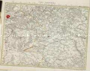
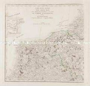
Regionalkarte
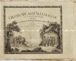
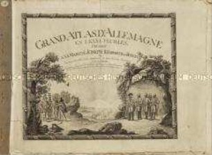
Grand Atlas D'Allemagne. Übersicht: Plan de la Nouvelle Carte Geographique Speciale D'Allemagne
- Alternativer Titel
-
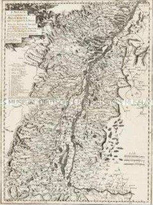
PLAN / DE LA NOUVELLE CARTE GEOGRAPHIQUE SPECIALE D'ALLEMAGNE
- Standort
-
Deutsches Historisches Museum, Berlin
- Inventarnummer
-
Do 2006/1059.82
- Maße
-
Höhe x Breite: 56,5 x 78 cm, Höhe: 56,5 cm, Breite: 78 cm, Tiefe: 3 cm (Atlas)
Höhe x Breite: 56,5 x 78 cm (Blatt)
Höhe x Breite: 52 x 68 cm (Platte)
Höhe x Breite: 46 x 59 cm (Karte)
- Material/Technik
-
Papier, Kupferstich, koloriert, gebunden |Fadenheftung
- Klassifikation
-
Kartografie (Gattung)
- Bezug (was)
-
Deutschland
- Ereignis
-
Herstellung
- (wer)
-
Verleger, Militärkartograph: Johann Wilhelm Abraham Jaeger
- (wo)
-
Frankfurt (Main) [historisch: Frankfurt, Reichsstadt], Deutschland
- (wann)
-
zwischen 1782 und 1789
- Rechteinformation
-
Deutsches Historisches Museum
- Letzte Aktualisierung
-
24.03.2023, 09:28 MEZ
Datenpartner
Dieses Objekt wird bereitgestellt von:
Stiftung Deutsches Historisches Museum. Bei Fragen zum Objekt wenden Sie sich bitte an den Datenpartner.
Stiftung Deutsches Historisches Museum. Bei Fragen zum Objekt wenden Sie sich bitte an den Datenpartner.
Objekttyp
- Regionalkarte
Beteiligte
- Verleger, Militärkartograph: Johann Wilhelm Abraham Jaeger
Entstanden
- zwischen 1782 und 1789
Ähnliche Objekte (12)
Grand Atlas d'Allemagne en LXXXI Feuilles
Grand Atlas D'Allemagne. Blatt 1: Grand Atlas D'Allemagne en LXXXI Feuilles, dedié a sa Majesté Joseph II, Empereur des Romains

Carte Générale de l'Empire d'Allemagne. Mit einer Übersichtskarte
Grand Atlas . Bl. 55 (Frankreich): Pour servir de Suite au grand Atlas d'Allemagne
Carte d'une partie des Pays-Bas, pour servir de Supplement a la Carte de l'Empire d'Allemagne
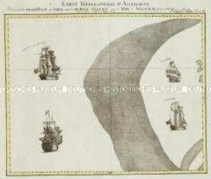
Grand Atlas . Bl. 10 (Nordsee): Contenante le Grand Banc de Sable, appellè De Bree Vertien, dans la Mer d'Allemagne.
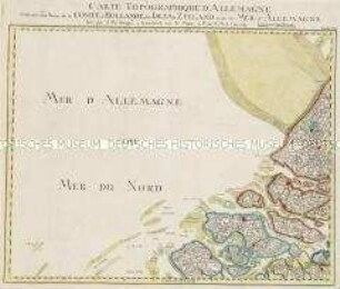
Grand Atlas . Bl. 19 (Holland, Nordsee): Contenant une Partie de la Comté d'Hollande, des Isles de Zeeland et de la Mer d'Allemagne
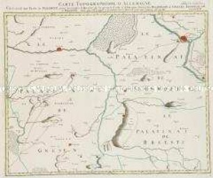
Grand Atlas . Bl. 18 (Polen. Gnesen): Contenant une Partie de Pologne, pour acclompir le Quarre de la grande Carte d'Allemagne, savoir les Palatinats de Gnesen, Inowrozlaw, et Brsestz.
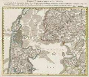
Grand Atlas . Bl. 11 (Holland, Westfriesland): Contenant une Partie des Provinces Unies, savoir la Province de Friesland Occidentale, une Partie d'Over Yssel, de Gueldre, d'Hollande Septentrionale, de differentes Isles de la Meer d'Allemagne, et du Zuider See.
L'Alsace, ou Conquestes du Roy, en Allemagne, tant decà que delà le Rhein

Empereurs D'Allemagne

Histoire d'Allemagne
Grand Atlas d'Allemagne en LXXXI Feuilles
Grand Atlas D'Allemagne. Blatt 1: Grand Atlas D'Allemagne en LXXXI Feuilles, dedié a sa Majesté Joseph II, Empereur des Romains
Carte Générale de l'Empire d'Allemagne. Mit einer Übersichtskarte
Grand Atlas . Bl. 55 (Frankreich): Pour servir de Suite au grand Atlas d'Allemagne
Carte d'une partie des Pays-Bas, pour servir de Supplement a la Carte de l'Empire d'Allemagne
Grand Atlas . Bl. 10 (Nordsee): Contenante le Grand Banc de Sable, appellè De Bree Vertien, dans la Mer d'Allemagne.
Grand Atlas . Bl. 19 (Holland, Nordsee): Contenant une Partie de la Comté d'Hollande, des Isles de Zeeland et de la Mer d'Allemagne
Grand Atlas . Bl. 18 (Polen. Gnesen): Contenant une Partie de Pologne, pour acclompir le Quarre de la grande Carte d'Allemagne, savoir les Palatinats de Gnesen, Inowrozlaw, et Brsestz.
Grand Atlas . Bl. 11 (Holland, Westfriesland): Contenant une Partie des Provinces Unies, savoir la Province de Friesland Occidentale, une Partie d'Over Yssel, de Gueldre, d'Hollande Septentrionale, de differentes Isles de la Meer d'Allemagne, et du Zuider See.
L'Alsace, ou Conquestes du Roy, en Allemagne, tant decà que delà le Rhein
Empereurs D'Allemagne