- Location
-
Herzog August Bibliothek, Wolfenbüttel
- Inventory number
-
Sammlung Wagner A20
- Measurements
-
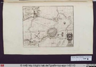
Höhe: 150 mm (Platte)
Breite: 209 mm
Höhe: 171 mm (Blatt)
Breite: 238 mm
- Material/Technique
-
Radierung, Handkolorierung
- Inscription/Labeling
-
Inschrift: Plan de la Rade de NAVARIN. Pl. 90.
- Related object and literature
-
beschrieben in: Zacharakis, Christos G.: A catalogue of printed maps of Greece: 1477-1800, Athens: Sylvia Ioannou Foundation, 2009, S. 268, [3020/1982].
- Classification
-
Druckgraphik (Gattung)
- Subject (what)
-
Topographie
Insel
Landkarte
Mittelmeer
- Culture
-
Französisch
- Event
-
Herstellung
- (who)
- (when)
-
1764-1804
- Delivered via
- Last update
-
13.06.2023, 2:16 PM CEST
Data provider
This object is provided by:
Herzog August Bibliothek Wolfenbüttel. If you have any questions about the object, please contact the data provider.
Herzog August Bibliothek Wolfenbüttel. If you have any questions about the object, please contact the data provider.
Object type
- Druckgraphik
Associated
- Roux, Joseph (Inventor)
- Gravier, Jean (Verleger)
- Unbekannt (Stecher)
Time of origin
- 1764-1804
Other Objects (12)
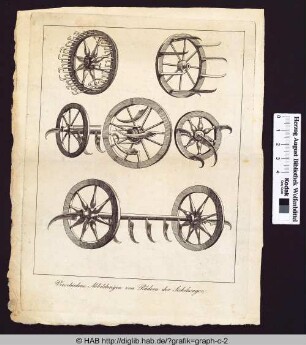
Verschiedene Abbildungen von Rädern der Sichelwagen
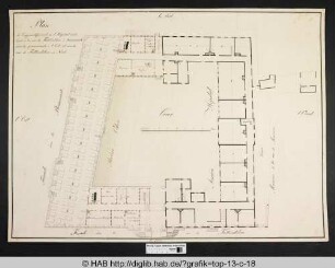
Plan de l'aggrandissement de l'Hopital militaire à la rue de Fallersleben à Brunsvick.
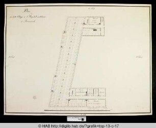
Plan du belle Etage de l'Hopital militaire à Brunsvick.
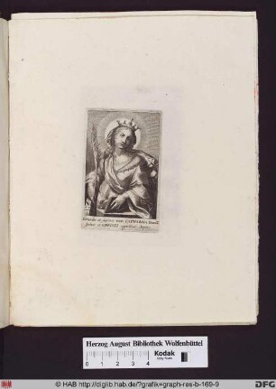
Die Heilige Katharina von Alexandria mit Palmzweig Buch und Rad.
Plan de la Situation de Bronsviv
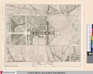
Le Plan de Vaux
![Henry De Lorraie Conte De Chaligny; [Henri de Lorraine de Moy]](https://iiif.deutsche-digitale-bibliothek.de/image/2/f8a2238b-695b-4444-a30f-83737ca1494d/full/!306,450/0/default.jpg)
Henry De Lorraie Conte De Chaligny; [Henri de Lorraine de Moy]
![Henry Dvc de Montpensier Pair de France; [Henri de Bourbon de Montpensier]](https://iiif.deutsche-digitale-bibliothek.de/image/2/e9f457d5-e6ca-4825-888a-55fee34afed4/full/!306,450/0/default.jpg)
Henry Dvc de Montpensier Pair de France; [Henri de Bourbon de Montpensier]
![Henry de Bovrbon Prince de Conde; [Henri de Condé]](https://iiif.deutsche-digitale-bibliothek.de/image/2/a74d0aaf-ab07-48cc-a097-f001f9d0c358/full/!306,450/0/default.jpg)
Henry de Bovrbon Prince de Conde; [Henri de Condé]
![[François de Bourbon de Conti]](https://iiif.deutsche-digitale-bibliothek.de/image/2/9ddd490b-5e1d-4cf6-a0a8-8ddae0fabeb3/full/!306,450/0/default.jpg)
[François de Bourbon de Conti]
![[Anne Hilarion de Costentin de Tourville]](https://iiif.deutsche-digitale-bibliothek.de/image/2/7d1178d6-a628-485a-85a3-65e5c4c72695/full/!306,450/0/default.jpg)
[Anne Hilarion de Costentin de Tourville]
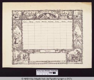
Stunden-Plan
Verschiedene Abbildungen von Rädern der Sichelwagen
Plan de l'aggrandissement de l'Hopital militaire à la rue de Fallersleben à Brunsvick.
Plan du belle Etage de l'Hopital militaire à Brunsvick.
Die Heilige Katharina von Alexandria mit Palmzweig Buch und Rad.
Plan de la Situation de Bronsviv
Le Plan de Vaux
Henry De Lorraie Conte De Chaligny; [Henri de Lorraine de Moy]
Henry Dvc de Montpensier Pair de France; [Henri de Bourbon de Montpensier]
Henry de Bovrbon Prince de Conde; [Henri de Condé]
[François de Bourbon de Conti]
[Anne Hilarion de Costentin de Tourville]