Karte
A map of the island of Jamaica. : Divided into counties and parishes, for the History of the British West Indies by Bryan Edwards Esq. 1794.

- Language
-
Englisch
- Bibliographic citation
-
Edwards, Bryan. - The history, civil and commercial, of the British West Indies : with a continuation to the present time ; Atlas
- Published
-
1818
- Last update
-
09.05.2025, 3:05 PM CEST
Data provider
This object is provided by:
Ibero-Amerikanisches Institut - Stiftung Preußischer Kulturbesitz. If you have any questions about the object, please contact the data provider.
Ibero-Amerikanisches Institut - Stiftung Preußischer Kulturbesitz. If you have any questions about the object, please contact the data provider.
Object type
- Karte
Time of origin
- 1818
Other Objects (12)

BRYAN ADAMS. THE BEST OF ME. LIVE
Representing the Holocaust : in honour of Bryan Burns

Traumatic Migration of the Bryan Cervical Disc Arthroplasty
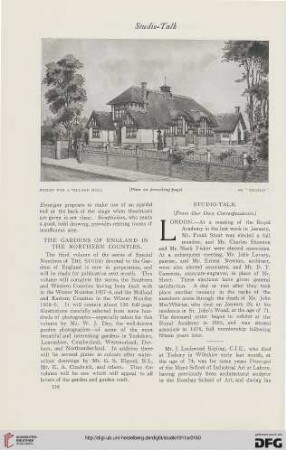
The gardens of England in the northern counties
The Rural Economy of the Southern Counties. 2
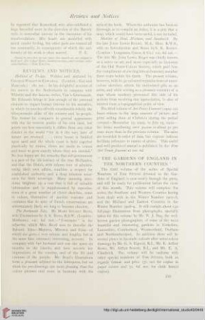
The gardens of England in the Northern counties
The Rural Economy of the Southern Counties. 1
Philips' Handy Atlas of the Counties of Ireland

The gardens of England in the Midland & Eastern counties
Life with the Bryans, [Hauptbd.].
Life with the Bryans, [Hauptbd.].
Life with the Bryans, [Hauptbd.].
BRYAN ADAMS. THE BEST OF ME. LIVE
Representing the Holocaust : in honour of Bryan Burns
Traumatic Migration of the Bryan Cervical Disc Arthroplasty
The gardens of England in the northern counties
The Rural Economy of the Southern Counties. 2
The gardens of England in the Northern counties
The Rural Economy of the Southern Counties. 1
Philips' Handy Atlas of the Counties of Ireland
The gardens of England in the Midland & Eastern counties
Life with the Bryans, [Hauptbd.].
Life with the Bryans, [Hauptbd.].