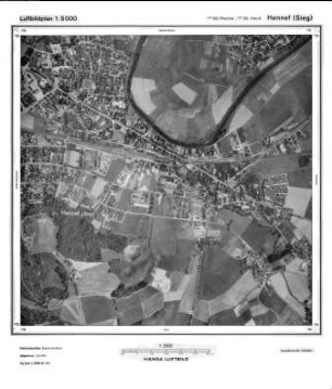
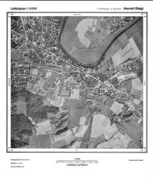
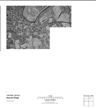
Luftbildpläne
Hennef (Sieg), Gauß-Krüger-Koordinaten: Rechtswert: 2590, Hochwert: 5626
- Reference number
-
RW 0435, 2428
- Dimensions
-
Maßstab: 1:5.000
- Further information
-
Land: Nordrhein-Westfalen
- Context
-
Hansa Luftbild, Luftbildpläne (Luftbildkarten) 1970-1985 >> 5. Nordrhein-Westfalen >> 5.6. Heisterschoß, Flurbereinigung
- Holding
-
RW 0435 Hansa Luftbild, Luftbildpläne (Luftbildkarten) 1970-1985
- Creator
-
Hersteller: Hansa Luftbild AG
- Provenance
-
Hansa Luftbild
- Date of creation
-
21.03.1975
- Other object pages
- Delivered via
- Last update
-
24.06.2025, 1:35 PM CEST
Data provider
This object is provided by:
Landesarchiv Nordrhein-Westfalen. Abteilung Rheinland. If you have any questions about the object, please contact the data provider.
Landesarchiv Nordrhein-Westfalen. Abteilung Rheinland. If you have any questions about the object, please contact the data provider.
Object type
- Luftbildpläne
Associated
- Hersteller: Hansa Luftbild AG
- Hansa Luftbild
Time of origin
- 21.03.1975
Other Objects (12)
Hennef (Sieg), Gauß-Krüger-Koordinaten: Rechtswert: 2590, Hochwert: 5626

Hennef Sieg, Gauß-Krüger-Koordinaten: Rechtswert: 2590, Hochwert: 5626
Hennef (Sieg), Gauß-Krüger-Koordinaten: Rechtswert: 2590, Hochwert: 5626
Hennef Sieg, Gauß-Krüger-Koordinaten: Rechtswert: 2590, Hochwert: 5626
Hennef Sieg, Gauß-Krüger-Koordinaten: Rechtswert: 2590, Hochwert: 5626
Hennef Sieg, Gauß-Krüger-Koordinaten: Rechtswert: 2590, Hochwert: 5626
Hennef Sieg, Gauß-Krüger-Koordinaten: Rechtswert: 2590, Hochwert: 5626
Hennef Sieg, Gauß-Krüger-Koordinaten: Rechtswert: 2590, Hochwert: 5626
Hennef Sieg West, Gauß-Krüger-Koordinaten: Rechtswert: 2588, Hochwert: 5626
Hennef Sieg West, Gauß-Krüger-Koordinaten: Rechtswert: 2588, Hochwert: 5626
Hennef West (Sieg), Gauß-Krüger-Koordinaten: Rechtswert: 2588, Hochwert: 5626
Hennef Sieg West, Gauß-Krüger-Koordinaten: Rechtswert: 2588, Hochwert: 5626
Hennef (Sieg), Gauß-Krüger-Koordinaten: Rechtswert: 2590, Hochwert: 5626
Hennef Sieg, Gauß-Krüger-Koordinaten: Rechtswert: 2590, Hochwert: 5626
Hennef (Sieg), Gauß-Krüger-Koordinaten: Rechtswert: 2590, Hochwert: 5626
Hennef Sieg, Gauß-Krüger-Koordinaten: Rechtswert: 2590, Hochwert: 5626
Hennef Sieg, Gauß-Krüger-Koordinaten: Rechtswert: 2590, Hochwert: 5626
Hennef Sieg, Gauß-Krüger-Koordinaten: Rechtswert: 2590, Hochwert: 5626
Hennef Sieg, Gauß-Krüger-Koordinaten: Rechtswert: 2590, Hochwert: 5626
Hennef Sieg, Gauß-Krüger-Koordinaten: Rechtswert: 2590, Hochwert: 5626
Hennef Sieg West, Gauß-Krüger-Koordinaten: Rechtswert: 2588, Hochwert: 5626
Hennef Sieg West, Gauß-Krüger-Koordinaten: Rechtswert: 2588, Hochwert: 5626
Hennef West (Sieg), Gauß-Krüger-Koordinaten: Rechtswert: 2588, Hochwert: 5626