- Location
-
Leibniz-Institut für Länderkunde e.V., Leipzig
- Other number(s)
-
HK 1063 (Signatur)
- Material/Technique
-
Grenzen kolor.
- Inscription/Labeling
-
Maßstab in graph. Form (Deutsche Meilen, Englische Meilen). - Titel, Maßstab und Abkürzungsverz. oberhalb des Kt.-Feldes. - Relief: Schraffen. - Nullmeridian: Greenwich
- Subject (what)
-
Altkarte
USA
Virginia (Va.)
Maryland (Md.)
Krieg
- Event
-
Veröffentlichung
- (who)
-
Justus Perthes (Verlag)
- (where)
-
Gotha
- (when)
-
1862
- Rights
-
Leibniz-Institut für Länderkunde e.V.
- Last update
-
15.05.2025, 12:44 PM CEST
Data provider
This object is provided by:
Leibniz-Institut für Länderkunde e. V.. If you have any questions about the object, please contact the data provider.
Leibniz-Institut für Länderkunde e. V.. If you have any questions about the object, please contact the data provider.
Object type
- Karte
Associated
- Justus Perthes (Verlag)
Time of origin
- 1862
Other Objects (12)
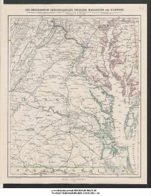
Der amerikanische Kriegsschauplatz zwischen Washington und Richmond
![Kriegsschauplatz der östlichen Mittelmeerländer : [Mit 3 Nebenkt.]](/assets/placeholder/searchResultMediaNoDigitisedMedia.png)
Kriegsschauplatz der östlichen Mittelmeerländer : [Mit 3 Nebenkt.]
Italienischer Kriegsschauplatz : Auf Grundlage von Stielers Handatlas u. Vogels Reichskarte ; [Mit 1 Nebenkt.]
Verbreitung und Vertheilung der Europäischen Vögel
![Südöstliches Frankreich [Hand-Atlas über alle Theile der Erde nach dem neuesten Zustande und über das Weltgebäude]](https://iiif.deutsche-digitale-bibliothek.de/image/2/e60cc306-39e1-462b-85d2-c01dd84b1ab3/full/!306,450/0/default.jpg)
Südöstliches Frankreich [Hand-Atlas über alle Theile der Erde nach dem neuesten Zustande und über das Weltgebäude]
![Sachsen, Thüringen und Benachbarte Laender [Hand-Atlas über alle Theile der Erde nach dem neuesten Zustande und über das Weltgebäude]](https://iiif.deutsche-digitale-bibliothek.de/image/2/598dcc7b-c9c6-4b9f-bdb1-30e95d13bb26/full/!306,450/0/default.jpg)
Sachsen, Thüringen und Benachbarte Laender [Hand-Atlas über alle Theile der Erde nach dem neuesten Zustande und über das Weltgebäude]
![Die Schweiz [Hand-Atlas über alle Theile der Erde nach dem neuesten Zustande und über das Weltgebäude]](https://iiif.deutsche-digitale-bibliothek.de/image/2/4f13b5cc-01df-4e49-a6fc-49862ed58b51/full/!306,450/0/default.jpg)
Die Schweiz [Hand-Atlas über alle Theile der Erde nach dem neuesten Zustande und über das Weltgebäude]
![Der Oesterreichische Kaiser-Staate [Hand-Atlas über alle Theile der Erde nach dem neuesten Zustande und über das Weltgebäude]](https://iiif.deutsche-digitale-bibliothek.de/image/2/5f229f84-2a49-4ba6-82c1-19cc1ac8e0ea/full/!306,450/0/default.jpg)
Der Oesterreichische Kaiser-Staate [Hand-Atlas über alle Theile der Erde nach dem neuesten Zustande und über das Weltgebäude]
![Die Britischen Inseln und Die Nord-See [Hand-Atlas über alle Theile der Erde nach dem neuesten Zustande und über das Weltgebäude]](https://iiif.deutsche-digitale-bibliothek.de/image/2/49ba9c71-45ee-40d6-a86f-72d9dffeeaad/full/!306,450/0/default.jpg)
Die Britischen Inseln und Die Nord-See [Hand-Atlas über alle Theile der Erde nach dem neuesten Zustande und über das Weltgebäude]
![Frankreich in IV Blättern - Nordwestliches Frankreich [Hand-Atlas über alle Theile der Erde nach dem neuesten Zustande und über das Weltgebäude]](https://iiif.deutsche-digitale-bibliothek.de/image/2/731139d8-25f9-4067-b290-91f4e41c4869/full/!306,450/0/default.jpg)
Frankreich in IV Blättern - Nordwestliches Frankreich [Hand-Atlas über alle Theile der Erde nach dem neuesten Zustande und über das Weltgebäude]
![Süd-America [Hand-Atlas über alle Theile der Erde nach dem neuesten Zustande und über das Weltgebäude]](https://iiif.deutsche-digitale-bibliothek.de/image/2/568e99b0-bc2d-4e65-8c27-449357f48fa0/full/!306,450/0/default.jpg)
Süd-America [Hand-Atlas über alle Theile der Erde nach dem neuesten Zustande und über das Weltgebäude]

Bergketten in Nord-Amerika
Der amerikanische Kriegsschauplatz zwischen Washington und Richmond
Kriegsschauplatz der östlichen Mittelmeerländer : [Mit 3 Nebenkt.]
Italienischer Kriegsschauplatz : Auf Grundlage von Stielers Handatlas u. Vogels Reichskarte ; [Mit 1 Nebenkt.]
Verbreitung und Vertheilung der Europäischen Vögel
Südöstliches Frankreich [Hand-Atlas über alle Theile der Erde nach dem neuesten Zustande und über das Weltgebäude]
Sachsen, Thüringen und Benachbarte Laender [Hand-Atlas über alle Theile der Erde nach dem neuesten Zustande und über das Weltgebäude]
Die Schweiz [Hand-Atlas über alle Theile der Erde nach dem neuesten Zustande und über das Weltgebäude]
Der Oesterreichische Kaiser-Staate [Hand-Atlas über alle Theile der Erde nach dem neuesten Zustande und über das Weltgebäude]
Die Britischen Inseln und Die Nord-See [Hand-Atlas über alle Theile der Erde nach dem neuesten Zustande und über das Weltgebäude]
Frankreich in IV Blättern - Nordwestliches Frankreich [Hand-Atlas über alle Theile der Erde nach dem neuesten Zustande und über das Weltgebäude]
Süd-America [Hand-Atlas über alle Theile der Erde nach dem neuesten Zustande und über das Weltgebäude]