- Standort
-
Leibniz-Institut für Länderkunde e.V., Leipzig
- Weitere Nummer(n)
-
HK 0437 (Signatur)
- Material/Technik
-
unkolor.
- Inschrift/Beschriftung
-
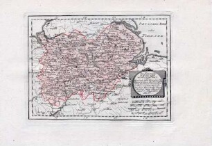
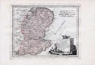
Maßstab in graph. Form (English Miles). - Titel unten links. - Maßstab und Wappen von Derby links Mitte. - Mit 2 Zeichnungen: The Devils Arse. Pooles Hole. - Aus: Universal Magazine. London. - Ohne Relief
- Bezug (was)
-
Altkarte
Verwaltungskarte
Großbritannien
Derbyshire
- Ereignis
-
Veröffentlichung
- (wer)
-
Kings Arms St. Pauls Church Yard (Verlag)
- (wo)
-
London
- (wann)
-
1748
- Rechteinformation
-
Leibniz-Institut für Länderkunde e.V.
- Letzte Aktualisierung
-
15.05.2025, 12:43 MESZ
Datenpartner
Dieses Objekt wird bereitgestellt von:
Leibniz-Institut für Länderkunde e. V.. Bei Fragen zum Objekt wenden Sie sich bitte an den Datenpartner.
Leibniz-Institut für Länderkunde e. V.. Bei Fragen zum Objekt wenden Sie sich bitte an den Datenpartner.
Objekttyp
- Karte
Beteiligte
- Kings Arms St. Pauls Church Yard (Verlag)
Entstanden
- 1748
Ähnliche Objekte (12)
Huntingdonensis comitatus Huntington shire

Herefordia comitatus vernacule Hereford shire
Comitatis Cantabrigiensis vernacule Cambridge shire
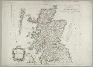
L'Ecosse divisée en Shires ou Comtés
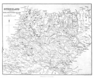
SUTHERLAND, WITH PARTS OF ROSS AND CAITHNESS SHIRES.
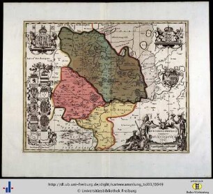
Des Königreichs England westilcher Theil oder Hereford Shire, Worcester Sh, Warwick Shire, Nordhampton Shire, Rutland Shira, Leicester Shire, Linkoln Shire, Notingham Shire, Derby Shire, Stafford Shire, Shrop Sh, und Sheshire. Nro. 82
![Schotland mit der nördlichen Spitze von England, den Shires, Northumberland, Durham u. e. Th. v. Cumberland [Hand-Atlas über alle Theile der Erde nach dem neuesten Zustande und über das Weltgebäude]](https://iiif.deutsche-digitale-bibliothek.de/image/2/d8621eaf-4339-4b06-9f53-9a3ebf46d97a/full/!306,450/0/default.jpg)
Schotland mit der nördlichen Spitze von England, den Shires, Northumberland, Durham u. e. Th. v. Cumberland [Hand-Atlas über alle Theile der Erde nach dem neuesten Zustande und über das Weltgebäude]
Shire tefilah
Otsar shire yeshurun
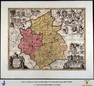
Des Königreichs England östlicher Theil, oder Surrey, Sussex, Kent, Middlesex, Essex, Suffolk, Norfolk, Chambridge Shire, Huntington Shire, Bedford Shire und Hertford Shire. Nro. 81

Geminard River (Ross-Shire)
Dumfries and Galloway shires
Huntingdonensis comitatus Huntington shire
Herefordia comitatus vernacule Hereford shire
Comitatis Cantabrigiensis vernacule Cambridge shire
L'Ecosse divisée en Shires ou Comtés
SUTHERLAND, WITH PARTS OF ROSS AND CAITHNESS SHIRES.
Des Königreichs England westilcher Theil oder Hereford Shire, Worcester Sh, Warwick Shire, Nordhampton Shire, Rutland Shira, Leicester Shire, Linkoln Shire, Notingham Shire, Derby Shire, Stafford Shire, Shrop Sh, und Sheshire. Nro. 82
Schotland mit der nördlichen Spitze von England, den Shires, Northumberland, Durham u. e. Th. v. Cumberland [Hand-Atlas über alle Theile der Erde nach dem neuesten Zustande und über das Weltgebäude]
Shire tefilah
Otsar shire yeshurun
Des Königreichs England östlicher Theil, oder Surrey, Sussex, Kent, Middlesex, Essex, Suffolk, Norfolk, Chambridge Shire, Huntington Shire, Bedford Shire und Hertford Shire. Nro. 81
Geminard River (Ross-Shire)