- Standort
-
Deutsches Historisches Museum, Berlin
- Inventarnummer
-
Gr 2013/42
- Maße
-
Höhe x Breite: 26,2 x 21 cm (Blatt)
- Material/Technik
-
Druckfarbe (schwarz), Papier, Radierung, Kupferstich
- Klassifikation
-
Druckgraphik (Gattung)
- Bezug (was)
-
Entdeckung
Seeschifffahrt
Kartographie
- Bezug (wer)
-
James Cook
- Ereignis
-
Herstellung
- (wer)
-
Druckerei: Carl Mayer's Kunstanstalt
- (wo)
-
Deutschland
- (wann)
-
um 1845
- Rechteinformation
-
Deutsches Historisches Museum
- Letzte Aktualisierung
-
24.03.2023, 09:29 MEZ
Datenpartner
Dieses Objekt wird bereitgestellt von:
Stiftung Deutsches Historisches Museum. Bei Fragen zum Objekt wenden Sie sich bitte an den Datenpartner.
Stiftung Deutsches Historisches Museum. Bei Fragen zum Objekt wenden Sie sich bitte an den Datenpartner.
Objekttyp
- Druck
Beteiligte
- Druckerei: Carl Mayer's Kunstanstalt
Entstanden
- um 1845
Ähnliche Objekte (12)

Bundesrepublik, Medaille auf James Cook
Bundesrepublik, Medaille auf James Cook
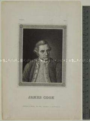
Porträt des britischen Entdeckungsreisenden James Cook
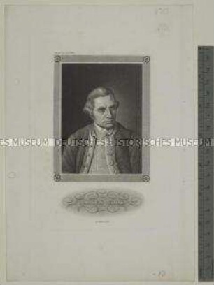
Porträt des britischen Entdeckungsreisenden James Cook
Porträt des britischen Entdeckungsreisenden James Cook

Porträt des James Cook
![Karte der Südküste von Neufundland in Canada, 1:225 000, Kupferstich, 1767 : Chart Of Part of the South Coast of Newfoundland : Including the Islands St. Peters And Miquelon with the Southern Entrance into the Gulph of St. Laurence / from actual Surveys Taken by Order of Commodore Pallisser. By James Cook. Larken sculp. 1767. Published by Permission, of the Right Honble. the Lords Commissioners of the Admiralty by James Cook. - [Ca. 1:220 000]. - London : I. Mount and T. Page, Thos. Jefferys, Andw. Dury And Carrington Bowles , 1767. - 1 Kt. : Kupferstich ; 173 x 63 cm](https://iiif.deutsche-digitale-bibliothek.de/image/2/80aea37e-e978-4099-85d4-5cf5ce9f4dab/full/!306,450/0/default.jpg)
Karte der Südküste von Neufundland in Canada, 1:225 000, Kupferstich, 1767 : Chart Of Part of the South Coast of Newfoundland : Including the Islands St. Peters And Miquelon with the Southern Entrance into the Gulph of St. Laurence / from actual Surveys Taken by Order of Commodore Pallisser. By James Cook. Larken sculp. 1767. Published by Permission, of the Right Honble. the Lords Commissioners of the Admiralty by James Cook. - [Ca. 1:220 000]. - London : I. Mount and T. Page, Thos. Jefferys, Andw. Dury And Carrington Bowles , 1767. - 1 Kt. : Kupferstich ; 173 x 63 cm

Cooks Leben
![Karte der Belle-Isle-Straße zwischen Labrador und Neufundland in Canada, 1:225 000, Kupferstich, 1766 : chart of the Straights of Bellisle with part of the coast of Newfoundland and Labradore : from actual surveys / Taken by order of Commodore Pallisser, Governor of Newfoundland, Labrador, &ca. By James Cook, surveyor. Larken, sculp.. - [Ca. 1:225 000]. - London : J. Mount & T. Page , 1766. - 1 Kt. : Kupferstich ; 61 x 78 cm](https://iiif.deutsche-digitale-bibliothek.de/image/2/ac114102-0dd0-41a6-a59c-fc301bd33480/full/!306,450/0/default.jpg)
Karte der Belle-Isle-Straße zwischen Labrador und Neufundland in Canada, 1:225 000, Kupferstich, 1766 : chart of the Straights of Bellisle with part of the coast of Newfoundland and Labradore : from actual surveys / Taken by order of Commodore Pallisser, Governor of Newfoundland, Labrador, &ca. By James Cook, surveyor. Larken, sculp.. - [Ca. 1:225 000]. - London : J. Mount & T. Page , 1766. - 1 Kt. : Kupferstich ; 61 x 78 cm
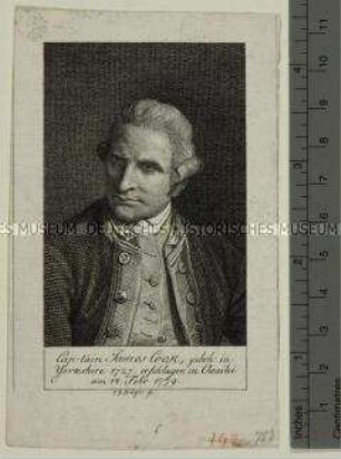
![Iames Cook : [Kupferstichportrait]](https://iiif.deutsche-digitale-bibliothek.de/image/2/9376ed60-3498-4d2c-97ab-118d321ea8e5/full/!306,450/0/default.jpg)
Iames Cook : [Kupferstichportrait]
![Karte der Ostküste von Neusüdwales in Australien, 1:2 200 000, Kupferstich, 1770 : Carte d'une Partie de la Cote de la Nle. Galles Merid le Depius Le Cap Tribulation Jusqu'au Détroit De L'Endeavour = Carte von einem Theil der Küste von Neu-Süd-Wallis vom Vorgebirge Tribulation an bis nach der Strasse Endevaour / Par Le Lieut. J. Cook. - [Ca. 1:2 200 000]. - [S.l.] , 1770. - 1 Kt. : Kupferstich ; 32 x 28 cm](https://iiif.deutsche-digitale-bibliothek.de/image/2/dd3c2f18-562f-4954-9ef1-926756ab57cb/full/!306,450/0/default.jpg)
Karte der Ostküste von Neusüdwales in Australien, 1:2 200 000, Kupferstich, 1770 : Carte d'une Partie de la Cote de la Nle. Galles Merid le Depius Le Cap Tribulation Jusqu'au Détroit De L'Endeavour = Carte von einem Theil der Küste von Neu-Süd-Wallis vom Vorgebirge Tribulation an bis nach der Strasse Endevaour / Par Le Lieut. J. Cook. - [Ca. 1:2 200 000]. - [S.l.] , 1770. - 1 Kt. : Kupferstich ; 32 x 28 cm
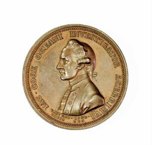
Erinnerungsmedaille an den Seefahrer und Entdecker James Cook
Bundesrepublik, Medaille auf James Cook
Bundesrepublik, Medaille auf James Cook
Porträt des britischen Entdeckungsreisenden James Cook
Porträt des britischen Entdeckungsreisenden James Cook
Porträt des britischen Entdeckungsreisenden James Cook
Porträt des James Cook
Karte der Südküste von Neufundland in Canada, 1:225 000, Kupferstich, 1767 : Chart Of Part of the South Coast of Newfoundland : Including the Islands St. Peters And Miquelon with the Southern Entrance into the Gulph of St. Laurence / from actual Surveys Taken by Order of Commodore Pallisser. By James Cook. Larken sculp. 1767. Published by Permission, of the Right Honble. the Lords Commissioners of the Admiralty by James Cook. - [Ca. 1:220 000]. - London : I. Mount and T. Page, Thos. Jefferys, Andw. Dury And Carrington Bowles , 1767. - 1 Kt. : Kupferstich ; 173 x 63 cm
Cooks Leben
Karte der Belle-Isle-Straße zwischen Labrador und Neufundland in Canada, 1:225 000, Kupferstich, 1766 : chart of the Straights of Bellisle with part of the coast of Newfoundland and Labradore : from actual surveys / Taken by order of Commodore Pallisser, Governor of Newfoundland, Labrador, &ca. By James Cook, surveyor. Larken, sculp.. - [Ca. 1:225 000]. - London : J. Mount & T. Page , 1766. - 1 Kt. : Kupferstich ; 61 x 78 cm
Iames Cook : [Kupferstichportrait]
Karte der Ostküste von Neusüdwales in Australien, 1:2 200 000, Kupferstich, 1770 : Carte d'une Partie de la Cote de la Nle. Galles Merid le Depius Le Cap Tribulation Jusqu'au Détroit De L'Endeavour = Carte von einem Theil der Küste von Neu-Süd-Wallis vom Vorgebirge Tribulation an bis nach der Strasse Endevaour / Par Le Lieut. J. Cook. - [Ca. 1:2 200 000]. - [S.l.] , 1770. - 1 Kt. : Kupferstich ; 32 x 28 cm