Karte / Plan
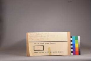
Westfalen topographische Karte Blatt 11 Arnheim, Xanten (1805) 1959 48 x 49 1 : 100 000 Nachdruck Generalmajor von LeCoq B Nr. 26
- Former reference number
-
B 26
- Further information
-
Ort: Westfalen
- Context
-
Karten A (Allgemein) >> 1. Topographische Karte, Übersichtskarten >> 1.1. Geographische, topographische Karten
- Holding
-
W 051 Karten A (Allgemein)
- Indexentry place
-
Westfalen
Arnheim, topographische Karte s. Westfalen, 1959
Westfalen, topographische Karte, Übersicht, 1959
Xanten, topographische Karte s. Westfalen, 1959
- Date of creation
-
1959
- Other object pages
- Provenance
-
Sammlungsregistraturbildner
- Delivered via
- Last update
-
17.09.2025, 2:39 PM CEST
Data provider
This object is provided by:
Landesarchiv Nordrhein-Westfalen. Abteilung Westfalen. If you have any questions about the object, please contact the data provider.
Landesarchiv Nordrhein-Westfalen. Abteilung Westfalen. If you have any questions about the object, please contact the data provider.
Object type
- Karten / Pläne
Time of origin
- 1959
Other Objects (12)

Lecoq (le Coq)
LeCoq Turkestan
LeCoq Turkestan
LeCoq : ein sächsisches Soldatenleben
Korrespondenz des Barons de Gaultier mit LeCoq zu London

Westfalen topographische Karte Sektion 11 Arnheim, Xanten 1805 54 x 56 1 Meile = 8,4 cm Stich Carl Jättnig, Berlin Generalmajor von LeCoq B Nr. 25

Westfalen topographische Karte Sektion 11 Arnheim, Xanten 1805 54 x 56 1 Meile = 8,4 cm Stich Carl Jättnig, Berlin Generalmajor von LeCoq B Nr. 25
![Lettres de Son Excellence Monseigneur le Comte de Manteuffel à Monseigneur LeCoq à Londres [Briefe Seiner Exzellenz Graf von Manteuffel an Herrn LeCoq in London]](https://iiif.deutsche-digitale-bibliothek.de/image/2/c54a73fd-39e4-40a6-8298-241d3f9fccce/full/!306,450/0/default.jpg)
Lettres de Son Excellence Monseigneur le Comte de Manteuffel à Monseigneur LeCoq à Londres [Briefe Seiner Exzellenz Graf von Manteuffel an Herrn LeCoq in London]
Korrespondenz des Grafen von Manteuffel mit LeCoq zu London, Bd. 1
Korrespondenz des Grafen von Manteuffel mit LeCoq zu London, Bd. 4
Korrespondenz des Grafen von Manteuffel mit LeCoq zu London, Bd. 3

Korrespondenz des Grafen von Manteuffel mit LeCoq zu London, Bd. 2
Lecoq (le Coq)
LeCoq Turkestan
LeCoq Turkestan
LeCoq : ein sächsisches Soldatenleben
Korrespondenz des Barons de Gaultier mit LeCoq zu London
Westfalen topographische Karte Sektion 11 Arnheim, Xanten 1805 54 x 56 1 Meile = 8,4 cm Stich Carl Jättnig, Berlin Generalmajor von LeCoq B Nr. 25
Westfalen topographische Karte Sektion 11 Arnheim, Xanten 1805 54 x 56 1 Meile = 8,4 cm Stich Carl Jättnig, Berlin Generalmajor von LeCoq B Nr. 25
Lettres de Son Excellence Monseigneur le Comte de Manteuffel à Monseigneur LeCoq à Londres [Briefe Seiner Exzellenz Graf von Manteuffel an Herrn LeCoq in London]
Korrespondenz des Grafen von Manteuffel mit LeCoq zu London, Bd. 1
Korrespondenz des Grafen von Manteuffel mit LeCoq zu London, Bd. 4
Korrespondenz des Grafen von Manteuffel mit LeCoq zu London, Bd. 3