Karte / Plan
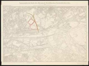
Topographische Karte des Rheinisch-Westfälischen Steinkohlenbezirks
enthält u.a.: Blatt Herten Nr. 170,
- Archivaliensignatur
-
BBA 4, 1831
- Maße
-
Höhe: 58,5 cm; Breite: 80 cm
- Kontext
-
Ewald-Kohle AG, Recklinghausen >> Karten / Pläne / Risse der Ewald-Kohle AG
- Bestand
-
BBA 4 Ewald-Kohle AG, Recklinghausen
- Indexbegriff Sache
-
Karte
- Indexbegriff Ort
-
Ruhrgebiet
- Urheber
-
Westfälische Berggewerkschaftskasse (Bochum)
- Laufzeit
-
1974
- Geliefert über
- Letzte Aktualisierung
-
05.11.2025, 16:18 MEZ
Datenpartner
Dieses Objekt wird bereitgestellt von:
Montanhistorisches Dokumentationszentrum. Bei Fragen zum Objekt wenden Sie sich bitte an den Datenpartner.
Montanhistorisches Dokumentationszentrum. Bei Fragen zum Objekt wenden Sie sich bitte an den Datenpartner.
Objekttyp
- Karten und Pläne
Beteiligte
- Westfälische Berggewerkschaftskasse (Bochum)
Entstanden
- 1974
Ähnliche Objekte (12)

Topographische Karte des Rheinisch-Westfälischen Steinkohlenbezirks
Rheinisch-Westfälisches Industriegebiet, topographische Karte
Rheinisch-Westfälisches Industriegebiet, topographische Karte
Karte der Kanalverbindungen im rheinisch-westfälischen Industriebezirk
Topographische Karte des Rheinisch-Westfälischen Steinkohlebezirks Oberhausen-Osterfeld. Zum Projekt gehörend: Hermann Mattern, Revierpark Vonderort, Oberhausen: Topographische Karte 1:10000
Geologische Karte des rheinisch-westfälischen Steinkohlengebietes, Lfg. 3.
Geologische Karte des rheinisch-westfälischen Steinkohlengebietes, Lfg. 5.
Geologische Karte des rheinisch-westfälischen Steinkohlengebietes, Lfg. 2.
Geologische Karte des rheinisch-westfälischen Steinkohlengebietes, Lfg. 4.
Geologische Karte des rheinisch-westfälischen Steinkohlengebietes, Lfg. 1.
![[Karte der Haupteisenbahnverbindungen im rheinisch- westfälischen Industriegebiet]. Gez. Debus](https://iiif.deutsche-digitale-bibliothek.de/image/2/874d22e6-d824-4f16-a182-ba6d656c2ce9/full/!306,450/0/default.jpg)
[Karte der Haupteisenbahnverbindungen im rheinisch- westfälischen Industriegebiet]. Gez. Debus
Karte des Westfälischen Reichskreises
Topographische Karte des Rheinisch-Westfälischen Steinkohlenbezirks
Rheinisch-Westfälisches Industriegebiet, topographische Karte
Rheinisch-Westfälisches Industriegebiet, topographische Karte
Karte der Kanalverbindungen im rheinisch-westfälischen Industriebezirk
Topographische Karte des Rheinisch-Westfälischen Steinkohlebezirks Oberhausen-Osterfeld. Zum Projekt gehörend: Hermann Mattern, Revierpark Vonderort, Oberhausen: Topographische Karte 1:10000
Geologische Karte des rheinisch-westfälischen Steinkohlengebietes, Lfg. 3.
Geologische Karte des rheinisch-westfälischen Steinkohlengebietes, Lfg. 5.
Geologische Karte des rheinisch-westfälischen Steinkohlengebietes, Lfg. 2.
Geologische Karte des rheinisch-westfälischen Steinkohlengebietes, Lfg. 4.
Geologische Karte des rheinisch-westfälischen Steinkohlengebietes, Lfg. 1.
[Karte der Haupteisenbahnverbindungen im rheinisch- westfälischen Industriegebiet]. Gez. Debus