Altkarte
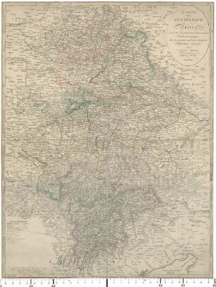
Karte vom Königreich Baiern : nach den bewährtesten astronomischen Ortsbestimmungen und den neuesten und zuverlässigsten Hilfsmitteln entworfen
- Standort
-
München, Bayerische Staatsbibliothek -- Mapp. XI,52 w
- Maße
-
73 x 49 cm
- Umfang
-
1 Kt.
- Anmerkungen
-
Kupferstich
Maßstab in graph. Form (Dt. od. geograph. Meile)
- Schlagwort
-
Geschichte 1806-1918
Bayern
- Ereignis
-
Veröffentlichung
- (wo)
-
Augsburg
- (wann)
-
1817
- Beteiligte Personen und Organisationen
- URN
-
urn:nbn:de:bvb:12-bsb00010904-4
- Letzte Aktualisierung
-
16.04.2025, 08:32 MESZ
Datenpartner
Dieses Objekt wird bereitgestellt von:
Bayerische Staatsbibliothek. Bei Fragen zum Objekt wenden Sie sich bitte an den Datenpartner.
Bayerische Staatsbibliothek. Bei Fragen zum Objekt wenden Sie sich bitte an den Datenpartner.
Objekttyp
- Altkarte
Beteiligte
Entstanden
- 1817
Ähnliche Objekte (12)
Karte vom Königreich Baiern : nach den bewährtesten astronomischen Ortsbestimmungen und den neuesten und zuverlässigsten Hilfsmitteln entworfen
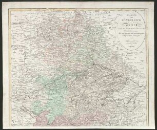
Karte vom Königreich Baiern : nach den bewährtesten astronomischen Ortsbestimmungen und den neuesten und zuverlässigsten Hilfsmitteln entworfen
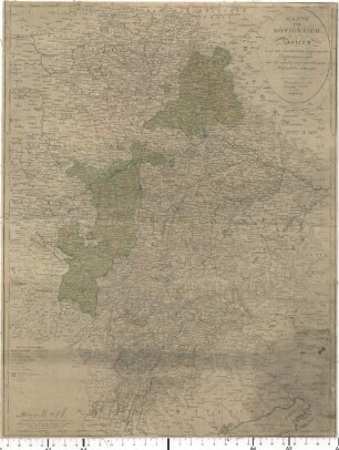
Karte vom Königreich Baiern : nach den bewährtesten astronomischen Ortsbestimmungen und den neuesten und zuverlässigsten Hilfsmitteln entworfen

Karte vom Königreich Wirtemberg nebst den Fürstenthüm. Hohenzollern-Hechingen und Sigmaringen : nach den allerneuesten astronomischen Ortsbestimmungen und zuverlässigsten Hilfsmitteln

Spanien und Portugal. Nach den zuverlässigsten Ortsbestimmungen und andern guten Hilfsquellen entworfen
!["Karte vom Königreich Böheim [Böhmen] nach den zuverläßigsten Hilfsmitteln entworfen und nach den astronomischen Ortsbestimmungen des Herrn Canonicus David berichtigt"](/assets/placeholder/searchResultMediaNoDigitisedMedia.png)
"Karte vom Königreich Böheim [Böhmen] nach den zuverläßigsten Hilfsmitteln entworfen und nach den astronomischen Ortsbestimmungen des Herrn Canonicus David berichtigt"
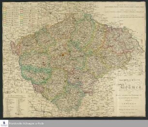
Das Königreich Böhmen nach Davids astronomischen Bestimmungen und den zuverläßigsten Spezialkarten
"Charte vom Königreich Böhmen nach Murdochischer Projection entworfen, nach den neuesten zuverläßigsten astronomischen Ortsbestimmungen berichtigt und revidiret auf der Seeberger und Prager Sternwarte"

Die besten und zuverlässigsten Gemüsesortenzüchtungen
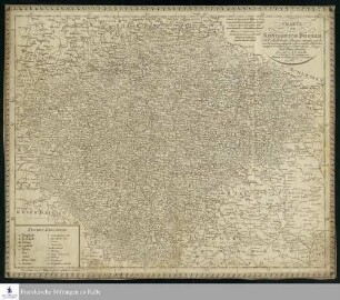
Charte vom Königreich Böheim : Nach Murdochischer Projection entworfen, nach den neuesten und zuverlässigsten astronomischen Ortsbestimmungen berichtiget, und revidiret auf der Seeberger, und Prager Sternwarte
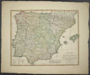
Charte von Spanien und Portugal : Nach Murdochischer Projection entworfen nach den neuesten und zuverlässigsten astronomischen Ortsbestimmungen berichtiget und revidiret auf der Sternwarte Seeberg bey Gotha
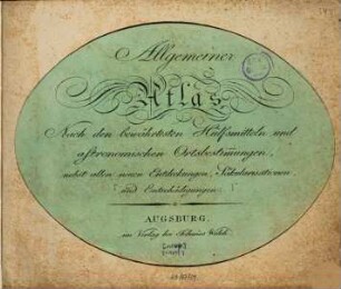
Allgemeiner Atlas : Nach den bewährtesten Hülfsmitteln und astronomischen Ortsbestimmungen, nebst allen neuen Entdeckungen, Säkularisationen, und Entschädigungen
Karte vom Königreich Baiern : nach den bewährtesten astronomischen Ortsbestimmungen und den neuesten und zuverlässigsten Hilfsmitteln entworfen
Karte vom Königreich Baiern : nach den bewährtesten astronomischen Ortsbestimmungen und den neuesten und zuverlässigsten Hilfsmitteln entworfen
Karte vom Königreich Baiern : nach den bewährtesten astronomischen Ortsbestimmungen und den neuesten und zuverlässigsten Hilfsmitteln entworfen
Karte vom Königreich Wirtemberg nebst den Fürstenthüm. Hohenzollern-Hechingen und Sigmaringen : nach den allerneuesten astronomischen Ortsbestimmungen und zuverlässigsten Hilfsmitteln
Spanien und Portugal. Nach den zuverlässigsten Ortsbestimmungen und andern guten Hilfsquellen entworfen
"Karte vom Königreich Böheim [Böhmen] nach den zuverläßigsten Hilfsmitteln entworfen und nach den astronomischen Ortsbestimmungen des Herrn Canonicus David berichtigt"
Das Königreich Böhmen nach Davids astronomischen Bestimmungen und den zuverläßigsten Spezialkarten
"Charte vom Königreich Böhmen nach Murdochischer Projection entworfen, nach den neuesten zuverläßigsten astronomischen Ortsbestimmungen berichtigt und revidiret auf der Seeberger und Prager Sternwarte"
Die besten und zuverlässigsten Gemüsesortenzüchtungen
Charte vom Königreich Böheim : Nach Murdochischer Projection entworfen, nach den neuesten und zuverlässigsten astronomischen Ortsbestimmungen berichtiget, und revidiret auf der Seeberger, und Prager Sternwarte
Charte von Spanien und Portugal : Nach Murdochischer Projection entworfen nach den neuesten und zuverlässigsten astronomischen Ortsbestimmungen berichtiget und revidiret auf der Sternwarte Seeberg bey Gotha