Grafik | Landkarte
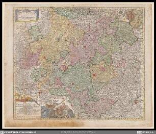
Territorii Sacri Romani Imperii liberae civitatis Norimbergensis nova et accurata delineatio geographica et topographica
Historische Karte der Region um Nürnberg mit kolorierten Grenzen einzelner Ämter und Herrschaftsgebieten. Titelkartusche oben links mit Allegorie vom Main, deutsche Legendenkartusche oben rechts und lateinischer Legendenkartusche mit Maßstäben unten rechts
- Alternative title
-
cum adjacentibus, quae illud ambiunt, terris
- Collection
-
Pictothek
- Identifier
-
36/A 1.25
- Source
-
Universitätsbibliothek Würzburg
- Extent
-
263 mm x 177 mm
- Language
-
Latein
- Subject
-
Altkarte
- Subject (where)
-
Nürnberg
- Event
-
Geistige Schöpfung
- (who)
- (when)
-
Ca. 1760
- Event
-
Veröffentlichung
- (who)
- URN
-
urn:nbn:de:bvb:20-36a125term73544250-2
- Last update
-
06.03.2025, 3:26 PM CET
Data provider
This object is provided by:
Universitätsbibliothek Würzburg. If you have any questions about the object, please contact the data provider.
Universitätsbibliothek Würzburg. If you have any questions about the object, please contact the data provider.
Object type
- Grafik
- Landkarte
Associated
- Lotter, Tobias Conrad
- Probst, Johann Michael
- Seutter, Albrecht Carl
Time of origin
- Ca. 1760
Other Objects (12)

Helvetiae, Rhaetia, Valesiae und Partis Sabaudiae Tabula

Ducatus Wurtembergici cum Territoriis conterminis

Superioris atque inferioris Alsatiae
Circulus Franconicus
Mappa Geographica exhibens Postas omnes tam vehiculares quam veredarias Totius Germaniæ : cum earum accurata distantia

Historia Circuli Bavarici, Nec Non Finitimarum Ac Insertarum Regionum : Cum Grat. et Priv. S. R. I. Vicar. in part. Rheni Svev. et Juris Francon.

Topographia Sedis Imperatoriae Moscovitarum Petropolis : anno 1744 designata iam publici iuris facta ; Cum Grat. et Privil. S. R. I. Vicariatus, in part. Rheni, Sveviae, et Iur. Franc. = Plan der Kayserlichen Residentz-Stadt Sankt Petersburg

Geographische Abzeichnung der in dem Meisnischen Creiß des Churfürstenthumbs Sachsen Liegenden Dioeces oder Superintendtur Grossen Hayn : Sambt ihren Staetten, Flecken und Dorffschafften in welcher gegend Ihro Konigl. Maj. in Pohl. u. Churfurstl. Durchl. zu Sachsen Fridericus Augustus im Monat Maj und Iunio A 1730 Beÿ dem Großen u. verwunderungs-würdigen Campement Dero gesamten Saechsischen Armee, nelbst denen Anwesenden Höchsten und Hohen Königlich. u. Fürstlich. auch andern Grossen Standes-Persohnen Dero Quartier genohmen ; Cum Gratia et Privil. S. I. R. Vicariatus, in partibus Rheni, Sveviae, et Juris Franconici

Madritum sive Mantua Carpetanorum celeberrima Castiliae Novae Civitas et Monarcharum Hispanicorum magnificentißima Regia sedes : Cu. Grat. et Pr. S. R. I. Vicariatus, in partibus Rheni, Sveviae, et Juris Franconici ; Sac. Caes. Majest. Geogr. = Madrit la plus celebre Ville dans la Castille nouvelle et la plus magnifique Residence des Monarques d'Espagne

Geographia Silesiae, 0

Circulus Bavaricus oder Geographische Grundlegung des Bairischen Craisses Sambt Angraenzenden Laendern : Alles auss den besten Authoribus Ordentlich u. fleissig zusamen getragen
Carte Nouvelle de l'Amerique Angloise : contenant tout ce que les Anglois possedent sur le Continent de l'Amerique Septentrionale Savoir le Canada, la Nouvelle Ecosse ou Acadie, les treize Provinces unies qui sont: les quatres Colonies de la Nouvelle Angleterre 1. New Hampshire, 2. Massachusetsbaye, 3. Rhode-Island, & 4. Conecticut, 5. la Nouvelle York, 6. Nouvelle Jersey, 7. Pensilvanie, 8. les Comtés de Newcastle Kent et Sussex sur la Delaware, 9. Mariland, 10. Virginie, 11. la Caroline Septentrionale, 12. la Caroline Meridionale et 13. Georgie: avec la Floride
Helvetiae, Rhaetia, Valesiae und Partis Sabaudiae Tabula
Ducatus Wurtembergici cum Territoriis conterminis
Superioris atque inferioris Alsatiae
Circulus Franconicus
Mappa Geographica exhibens Postas omnes tam vehiculares quam veredarias Totius Germaniæ : cum earum accurata distantia
Historia Circuli Bavarici, Nec Non Finitimarum Ac Insertarum Regionum : Cum Grat. et Priv. S. R. I. Vicar. in part. Rheni Svev. et Juris Francon.
Topographia Sedis Imperatoriae Moscovitarum Petropolis : anno 1744 designata iam publici iuris facta ; Cum Grat. et Privil. S. R. I. Vicariatus, in part. Rheni, Sveviae, et Iur. Franc. = Plan der Kayserlichen Residentz-Stadt Sankt Petersburg
Geographische Abzeichnung der in dem Meisnischen Creiß des Churfürstenthumbs Sachsen Liegenden Dioeces oder Superintendtur Grossen Hayn : Sambt ihren Staetten, Flecken und Dorffschafften in welcher gegend Ihro Konigl. Maj. in Pohl. u. Churfurstl. Durchl. zu Sachsen Fridericus Augustus im Monat Maj und Iunio A 1730 Beÿ dem Großen u. verwunderungs-würdigen Campement Dero gesamten Saechsischen Armee, nelbst denen Anwesenden Höchsten und Hohen Königlich. u. Fürstlich. auch andern Grossen Standes-Persohnen Dero Quartier genohmen ; Cum Gratia et Privil. S. I. R. Vicariatus, in partibus Rheni, Sveviae, et Juris Franconici
Madritum sive Mantua Carpetanorum celeberrima Castiliae Novae Civitas et Monarcharum Hispanicorum magnificentißima Regia sedes : Cu. Grat. et Pr. S. R. I. Vicariatus, in partibus Rheni, Sveviae, et Juris Franconici ; Sac. Caes. Majest. Geogr. = Madrit la plus celebre Ville dans la Castille nouvelle et la plus magnifique Residence des Monarques d'Espagne
Geographia Silesiae, 0
Circulus Bavaricus oder Geographische Grundlegung des Bairischen Craisses Sambt Angraenzenden Laendern : Alles auss den besten Authoribus Ordentlich u. fleissig zusamen getragen