Karten / Pläne
Neuhaus (Paderborn) Lageplan des Schlosses (Anf. 20.Jh.) 8 x 14 weiß-schwarz Foto Landsberg-Velen Nr. 506d
- Former reference number
-
Landsberg-Velen 506d
- Further information
-
Ort: Neuhaus, Paderborn
- Context
-
Karten A (Allgemein) >> 7. Bausachen >> 7.1. Bau- / Bebauungsplan >> 7.1.9. Orte N-O
- Holding
-
W 051 Karten A (Allgemein)
- Indexbegriff subject
-
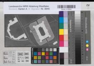
Lageplan, Schloß Neuhaus, 1950
Schloß Neuhaus, Lageplan, 1950
- Indexentry place
-
Neuhaus, Paderborn
Neuhaus, Schloß, Lageplan, 1950
- Provenance
-
Sammlungsregistraturbildner
- Date of creation
-
1950
- Other object pages
- Delivered via
- Last update
-
24.06.2025, 2:11 PM CEST
Data provider
This object is provided by:
Landesarchiv Nordrhein-Westfalen. Abteilung Westfalen. If you have any questions about the object, please contact the data provider.
Landesarchiv Nordrhein-Westfalen. Abteilung Westfalen. If you have any questions about the object, please contact the data provider.
Object type
- Karten / Pläne
Associated
- Sammlungsregistraturbildner
Time of origin
- 1950
Other Objects (12)
Neuhaus (Paderborn) Lageplan des Schlosses (Anf. 20.Jh.) 12 x 20 schwarz-weiß Foto Landsberg-Velen Nr. 506c

Familiengeschichte Reinhardt, Gaunitz, Dresden. Anf. 18.Jh.-1.Drittel 20.Jh.

Münster (Münster) Landsberger Hof Lageplan mit angekauftem Nachbargrundstück Anf. 20.Jh. 150 Fuß = 17,9 cm 52 x 39 Kopie mit Einzeichnung Greve Landsberg-Velen Nr. 582d

Deilinghofen (Hemer) Flurkarte Flur 6 1.V. 20.Jh. 1 : 25 000 67,5 x 99 Druck? Landsberg-Velen

Deilinghofen (Hemer) Flurkarte Flur 8 1.V. 20.Jh. 1 : 25 000 67,5 x 99 Druck? Landsberg-Velen

Velen (Velen) Schloß Stuckdecke Anf. 19.Jh. 25 Fuß = 38,8 cm 38 x 54,5 Zeichnung Landsberg-Velen Nr. 625

Gemen (Herrschaft) Grenzen (18. Jh.) 1.H. 20.Jh. 400 Ruten = 13 cm 49 x 70 Pause Landsberg-Velen Nr. 468
v. Landsberg-Velen
von Landsberg-Velen
Verzeichnisse 18.-20.Jh.
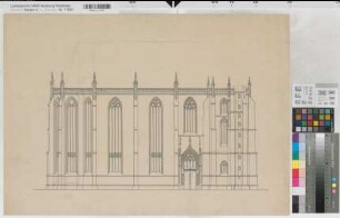
Soest (Soest) Wiesenkirche Seitenansicht ohne Türme Anf. 20.Jh. o.M. 51 x 73 Zeichnung Staatshochbauamt Soest

Benkhausen (Espelkamp) Vermessung des Alsweder Wiese Katasterauszug Anf. 20.Jh. 1 : 1000 32 x 32 Zeichnung Benkhausen
Neuhaus (Paderborn) Lageplan des Schlosses (Anf. 20.Jh.) 12 x 20 schwarz-weiß Foto Landsberg-Velen Nr. 506c
Familiengeschichte Reinhardt, Gaunitz, Dresden. Anf. 18.Jh.-1.Drittel 20.Jh.
Münster (Münster) Landsberger Hof Lageplan mit angekauftem Nachbargrundstück Anf. 20.Jh. 150 Fuß = 17,9 cm 52 x 39 Kopie mit Einzeichnung Greve Landsberg-Velen Nr. 582d
Deilinghofen (Hemer) Flurkarte Flur 6 1.V. 20.Jh. 1 : 25 000 67,5 x 99 Druck? Landsberg-Velen
Deilinghofen (Hemer) Flurkarte Flur 8 1.V. 20.Jh. 1 : 25 000 67,5 x 99 Druck? Landsberg-Velen
Velen (Velen) Schloß Stuckdecke Anf. 19.Jh. 25 Fuß = 38,8 cm 38 x 54,5 Zeichnung Landsberg-Velen Nr. 625
Gemen (Herrschaft) Grenzen (18. Jh.) 1.H. 20.Jh. 400 Ruten = 13 cm 49 x 70 Pause Landsberg-Velen Nr. 468
v. Landsberg-Velen
von Landsberg-Velen
Verzeichnisse 18.-20.Jh.
Soest (Soest) Wiesenkirche Seitenansicht ohne Türme Anf. 20.Jh. o.M. 51 x 73 Zeichnung Staatshochbauamt Soest