- Alternative title
-
PLAN / des Ville, Chateau, Mole, et Baye de / GIBRALTAR, / Vu du Côte du Nord de la Montagne.
- Location
-
Deutsches Historisches Museum, Berlin
- Inventory number
-
Do 2006/769
- Measurements
-
Höhe x Breite: 46 x 60,7 cm (Blatt)
Höhe x Breite: 39 x 54,3 cm (Karte)
Höhe x Breite: 41 x 57,7 cm (Platte)
- Material/Technique
-
Papier, Kupferstich, koloriert
- Classification
-
Kartografie (Gattung)
- Subject (what)
-
Gibraltar
- Event
-
Herstellung
- (who)
-
Geograph: Jacques Francois des Longchamps
Stecher: ? Tulpin
- (where)
-
Paris, Frankreich
- (when)
-
1779
- Rights
-
Deutsches Historisches Museum
- Last update
-
11.03.2023, 10:27 AM CET
Data provider
This object is provided by:
Stiftung Deutsches Historisches Museum. If you have any questions about the object, please contact the data provider.
Stiftung Deutsches Historisches Museum. If you have any questions about the object, please contact the data provider.
Object type
- Stadtplan
Associated
- Geograph: Jacques Francois des Longchamps
- Stecher: ? Tulpin
Time of origin
- 1779
Other Objects (12)
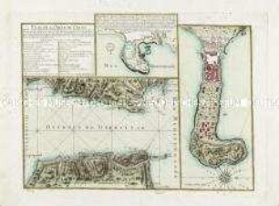
Plan De La Ville De Ceuta. Mit zwei Nebenkarten: Partie d'Alger; Detroit de Gibraltar
![Stadtplan von Koblenz, ca. 1:7 300, kolor. Kupferst., 1781 : Plan De Coblens Et Du Château D'Hermanstein. - [Ca. 1:7 300]. - Paris : Jaillot , 1781. - 1 Kt. : kolor. Kupferst. ; 55 x 42 cm](https://iiif.deutsche-digitale-bibliothek.de/image/2/218de761-a2c2-4cc7-be14-0e8218ff95ac/full/!306,450/0/default.jpg)
Stadtplan von Koblenz, ca. 1:7 300, kolor. Kupferst., 1781 : Plan De Coblens Et Du Château D'Hermanstein. - [Ca. 1:7 300]. - Paris : Jaillot , 1781. - 1 Kt. : kolor. Kupferst. ; 55 x 42 cm
Plan von Leipzig der Stadt und denen Vorstaedten
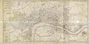
A New Plan of the City and Liberty of Westminster / A New Plan of the City of London and Borough of Southwark
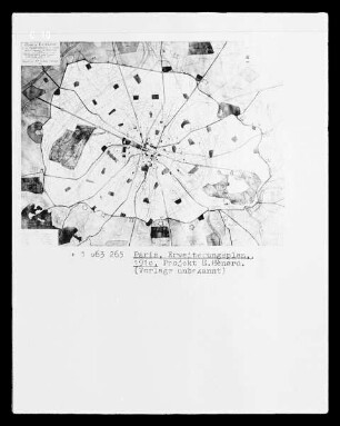
Paris, Stadtplan mit Erweiterungsplan, Projekt E. Hénard

Thematischer Stadtplan der Stadt während der Überschwemmung von 1966: Altezza raggiunta dalle acque nelle varie zone
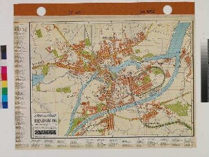
Plan der Stadt RENDSBURG

ohne Titel
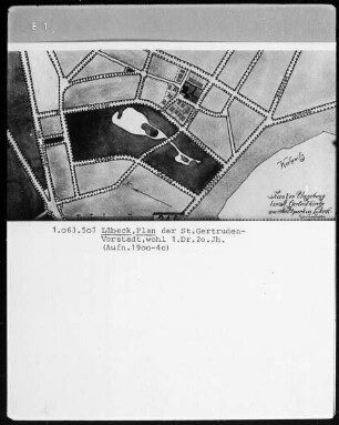
Lübeck. Plan der Sankt Gertruden-Vorstadt
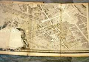
PLAN de PARIS. Vogelschauplan

Stadtplan von Berlin

Plan der Stadt Straßburg. Straßburg: R. Schultz, um 1900
Plan De La Ville De Ceuta. Mit zwei Nebenkarten: Partie d'Alger; Detroit de Gibraltar
Stadtplan von Koblenz, ca. 1:7 300, kolor. Kupferst., 1781 : Plan De Coblens Et Du Château D'Hermanstein. - [Ca. 1:7 300]. - Paris : Jaillot , 1781. - 1 Kt. : kolor. Kupferst. ; 55 x 42 cm
Plan von Leipzig der Stadt und denen Vorstaedten
A New Plan of the City and Liberty of Westminster / A New Plan of the City of London and Borough of Southwark
Paris, Stadtplan mit Erweiterungsplan, Projekt E. Hénard
Thematischer Stadtplan der Stadt während der Überschwemmung von 1966: Altezza raggiunta dalle acque nelle varie zone
Plan der Stadt RENDSBURG
ohne Titel
Lübeck. Plan der Sankt Gertruden-Vorstadt
PLAN de PARIS. Vogelschauplan
Stadtplan von Berlin