Geognostische Karte des Königreichs Bayern, XVIII. Kurze Erläuterungen zu dem Blatte Speyer
- Standort
-
München, Bayerische Staatsbibliothek -- BHS II C 314 b-18
- Umfang
-
77 S.
- Sprache
-
Deutsch
- Erschienen in
-
Geognostische Karte des Königreichs Bayern ; 18,1
- Ereignis
-
Veröffentlichung
- (wo)
-
Cassel
- (wer)
-
Fischer
- (wann)
-
1897
- Beteiligte Personen und Organisationen
- URN
-
urn:nbn:de:bvb:12-bsb11801208-0
- Letzte Aktualisierung
-
16.04.2025, 08:41 MESZ
Datenpartner
Dieses Objekt wird bereitgestellt von:
Bayerische Staatsbibliothek. Bei Fragen zum Objekt wenden Sie sich bitte an den Datenpartner.
Bayerische Staatsbibliothek. Bei Fragen zum Objekt wenden Sie sich bitte an den Datenpartner.
Beteiligte
Entstanden
- 1897
Ähnliche Objekte (12)
Geognostische Karte des Königreichs Bayern, XVIII. Kurze Erläuterungen zu dem Blatte Speyer
![Geognostische Karte des Königreichs Bayern, 16,[1]. Kurze Erläuterungen zu dem Blatte Nördlingen](https://iiif.deutsche-digitale-bibliothek.de/image/2/11a2719a-ee62-427c-9b05-628cb45b01f9/full/!306,450/0/default.jpg)
Geognostische Karte des Königreichs Bayern, 16,[1]. Kurze Erläuterungen zu dem Blatte Nördlingen

Geognostische Karte des Königreichs Bayern, XVIII. Abth. 5, Die Bayerische Rheinpfalz ;1. Blatt, Speyer
![Geognostische Karte des Königreichs Bayern, 17,[1]. Kurze Erläuterungen zu dem Blatte Ansbach (No. XVII)](https://iiif.deutsche-digitale-bibliothek.de/image/2/16c3b2bd-6b35-472a-9081-a15d2525f879/full/!306,450/0/default.jpg)
Geognostische Karte des Königreichs Bayern, 17,[1]. Kurze Erläuterungen zu dem Blatte Ansbach (No. XVII)
![Geognostische Karte des Königreichs Bayern, 15,[1]. Kurze Erläuterungen zu dem Blatte Ingolstadt (No. XV)](https://iiif.deutsche-digitale-bibliothek.de/image/2/39d8de4e-f8ce-486d-b738-28b8bafb0b6e/full/!306,450/0/default.jpg)
Geognostische Karte des Königreichs Bayern, 15,[1]. Kurze Erläuterungen zu dem Blatte Ingolstadt (No. XV)
Nachlese zu der Uebersicht der mineralogischen und geognostischen Literatur Baden's in: G. Leonhard: Geognostische Skizze des Grossherzogsthums Baden...

Kurze Erläuterung zu den Wandtafeln zur Veranschaulichung antiken Lebens und antiker Kunst

Fischer, Theodor; Würzburg, Münsterplatz; Sparkasse - Beleuchtungskörper in der Treppenhalle (Detail)
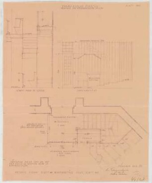
Fischer, Theodor; Planegg bei München (Bayern); Ev. Waldkirche - Windfang u. Emporentreppe (Grundriss, Ansicht, Schnitt)
![Bau- und Kunst-Denkmäler Thüringens, [...]. Der Amtsgerichtsbezirk Apolda](/assets/placeholder/searchResultMediaNoDigitisedMedia.png)
Bau- und Kunst-Denkmäler Thüringens, [...]. Der Amtsgerichtsbezirk Apolda
Handwörterbuch der Naturwissenschaften, Bd. 3.. Ei-Fluoreszenz
Lehrbuch der Chirurgie, Bd. 2.. Bauchdecken, Leber, Milz, Pankreas, Magen, Darm, Hernien, Harn- u. Geschlechtsorgane u. Becken
Geognostische Karte des Königreichs Bayern, XVIII. Kurze Erläuterungen zu dem Blatte Speyer
Geognostische Karte des Königreichs Bayern, 16,[1]. Kurze Erläuterungen zu dem Blatte Nördlingen
Geognostische Karte des Königreichs Bayern, XVIII. Abth. 5, Die Bayerische Rheinpfalz ;1. Blatt, Speyer
Geognostische Karte des Königreichs Bayern, 17,[1]. Kurze Erläuterungen zu dem Blatte Ansbach (No. XVII)
Geognostische Karte des Königreichs Bayern, 15,[1]. Kurze Erläuterungen zu dem Blatte Ingolstadt (No. XV)
Nachlese zu der Uebersicht der mineralogischen und geognostischen Literatur Baden's in: G. Leonhard: Geognostische Skizze des Grossherzogsthums Baden...
Kurze Erläuterung zu den Wandtafeln zur Veranschaulichung antiken Lebens und antiker Kunst
Fischer, Theodor; Würzburg, Münsterplatz; Sparkasse - Beleuchtungskörper in der Treppenhalle (Detail)
Fischer, Theodor; Planegg bei München (Bayern); Ev. Waldkirche - Windfang u. Emporentreppe (Grundriss, Ansicht, Schnitt)
Bau- und Kunst-Denkmäler Thüringens, [...]. Der Amtsgerichtsbezirk Apolda
Handwörterbuch der Naturwissenschaften, Bd. 3.. Ei-Fluoreszenz