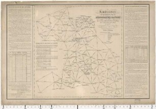
Topographischer Atlas vom Königreiche Baiern diesseits des Rhein, [74]. Illertissen
- Location
-
München, Bayerische Staatsbibliothek -- Mapp. XI,57 du-74
- Dimensions
-
50 x 79 cm
- Extent
-
1 Karte
- Language
-
Deutsch
- Notes
-
schwarz-weiß
Maßstab in graphischer Form (Eine Chaussée Meile zu 25406 baier. Fuss) Mitte unten
- Bibliographic citation
-
Topographischer Atlas vom Königreiche Baiern diesseits des Rhein ; 74
- Event
-
Veröffentlichung
- (where)
-
[München]
- (who)
-
[Topographisches Bureau]
- (when)
-
[1828?]
- Contributor
- URN
-
urn:nbn:de:bvb:12-bsb00011210-0
- Last update
-
16.04.2025, 8:38 AM CEST
Data provider
This object is provided by:
Bayerische Staatsbibliothek. If you have any questions about the object, please contact the data provider.
Bayerische Staatsbibliothek. If you have any questions about the object, please contact the data provider.
Associated
- Riedel, C.
- Schleich, Carl
- [Topographisches Bureau]
Time of origin
- [1828?]
Other Objects (12)
![74 Illertissen [Topographischer Atlas vom Königreiche Baiern]](https://iiif.deutsche-digitale-bibliothek.de/image/2/729bcac7-ba56-450b-a130-b0e66508e042/full/!306,450/0/default.jpg)
74 Illertissen [Topographischer Atlas vom Königreiche Baiern]
![Topographischer Atlas vom Königreiche Baiern diesseits des Rhein : [in 112 Blättern], [74]. Illertissen](https://iiif.deutsche-digitale-bibliothek.de/image/2/9081f6ba-d80e-43fe-b054-76e39f2487a3/full/!306,450/0/default.jpg)
Topographischer Atlas vom Königreiche Baiern diesseits des Rhein : [in 112 Blättern], [74]. Illertissen
![Topographischer Atlas vom Königreiche Baiern diesseits des Rhein : [in 112 Blättern], [74]. Illertissen](https://iiif.deutsche-digitale-bibliothek.de/image/2/760ba716-6aa8-4168-9887-ed199e13ae27/full/!306,450/0/default.jpg)
Topographischer Atlas vom Königreiche Baiern diesseits des Rhein : [in 112 Blättern], [74]. Illertissen
Topographischer Atlas vom Königreiche Baiern diesseits des Rhein, 0
![Topographischer Atlas vom Königreiche Baiern diesseits des Rhein, [76]. Landsberg](https://iiif.deutsche-digitale-bibliothek.de/image/2/05838c2d-30e2-49a8-8397-b458c7119211/full/!306,450/0/default.jpg)
Topographischer Atlas vom Königreiche Baiern diesseits des Rhein, [76]. Landsberg
![Topographischer Atlas vom Königreiche Baiern diesseits des Rhein, [89]. Kempten](https://iiif.deutsche-digitale-bibliothek.de/image/2/e67013fa-a647-40f5-b7ab-14a06d78982d/full/!306,450/0/default.jpg)
Topographischer Atlas vom Königreiche Baiern diesseits des Rhein, [89]. Kempten
![Topographischer Atlas vom Königreiche Baiern diesseits des Rhein, [76]. Landsberg](https://iiif.deutsche-digitale-bibliothek.de/image/2/2a225958-1ce1-4398-9ffa-607269c34fae/full/!306,450/0/default.jpg)
Topographischer Atlas vom Königreiche Baiern diesseits des Rhein, [76]. Landsberg
![Topographischer Atlas vom Königreiche Baiern diesseits des Rhein, [53]. Neuburg](https://iiif.deutsche-digitale-bibliothek.de/image/2/6132b2b6-decc-4aa9-95ae-4d99cfb1209e/full/!306,450/0/default.jpg)
Topographischer Atlas vom Königreiche Baiern diesseits des Rhein, [53]. Neuburg
![Topographischer Atlas vom Königreiche Baiern diesseits des Rhein, [67]. Weissenhorn](https://iiif.deutsche-digitale-bibliothek.de/image/2/2dc6e71e-911f-48db-bd3e-5ee5b7418d57/full/!306,450/0/default.jpg)
Topographischer Atlas vom Königreiche Baiern diesseits des Rhein, [67]. Weissenhorn
![Topographischer Atlas vom Königreiche Baiern diesseits des Rhein, [69]. Augsburg](https://iiif.deutsche-digitale-bibliothek.de/image/2/fd8c3c18-c9ed-4066-8a0f-cdd744a72f33/full/!306,450/0/default.jpg)
Topographischer Atlas vom Königreiche Baiern diesseits des Rhein, [69]. Augsburg
![Topographischer Atlas vom Königreiche Baiern diesseits des Rhein, [85]. Traunstein](https://iiif.deutsche-digitale-bibliothek.de/image/2/59d06738-7ab2-4064-8b6e-be2b1f2beb21/full/!306,450/0/default.jpg)
Topographischer Atlas vom Königreiche Baiern diesseits des Rhein, [85]. Traunstein
![Topographischer Atlas vom Königreiche Baiern diesseits des Rhein, [2]. Voelkershausen](https://iiif.deutsche-digitale-bibliothek.de/image/2/5f6ce429-99bf-42af-9ff1-75e5053d0066/full/!306,450/0/default.jpg)
Topographischer Atlas vom Königreiche Baiern diesseits des Rhein, [2]. Voelkershausen
74 Illertissen [Topographischer Atlas vom Königreiche Baiern]
Topographischer Atlas vom Königreiche Baiern diesseits des Rhein : [in 112 Blättern], [74]. Illertissen
Topographischer Atlas vom Königreiche Baiern diesseits des Rhein : [in 112 Blättern], [74]. Illertissen
Topographischer Atlas vom Königreiche Baiern diesseits des Rhein, 0
Topographischer Atlas vom Königreiche Baiern diesseits des Rhein, [76]. Landsberg
Topographischer Atlas vom Königreiche Baiern diesseits des Rhein, [89]. Kempten
Topographischer Atlas vom Königreiche Baiern diesseits des Rhein, [76]. Landsberg
Topographischer Atlas vom Königreiche Baiern diesseits des Rhein, [53]. Neuburg
Topographischer Atlas vom Königreiche Baiern diesseits des Rhein, [67]. Weissenhorn
Topographischer Atlas vom Königreiche Baiern diesseits des Rhein, [69]. Augsburg
Topographischer Atlas vom Königreiche Baiern diesseits des Rhein, [85]. Traunstein