Umgebungskarte
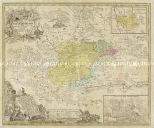
Canton Inter Catholicos primaria, Sive Illustris Helvetiorum Respublica Lucernensis
- Alternative title
-
Canton / Inter Catholicos / primaria, / Sive
- Location
-
Deutsches Historisches Museum, Berlin
- Inventory number
-
Do 2006/428
- Measurements
-
Höhe x Breite: 59 x 71,5 cm (Blatt)
Höhe x Breite: 46,7 x 54,5 cm (Karte)
Höhe x Breite: 50 x 58 cm (Platte)
- Material/Technique
-
Druckfarbe, Papier, Kupferstich, koloriert
- Classification
-
Kartografie (Gattung)
- Subject (what)
-
Schweiz
Luzern
- Event
-
Herstellung
- (who)
-
Stecher, Kartograf: Albrecht Carl Seutter
Kartograf: Gabriel Walser
- (where)
-
Augsburg, Deutschland
- (when)
-
um 1740
- Rights
-
Deutsches Historisches Museum
- Last update
-
09.12.42201, 9:59 AM CET
Data provider
This object is provided by:
Stiftung Deutsches Historisches Museum. If you have any questions about the object, please contact the data provider.
Stiftung Deutsches Historisches Museum. If you have any questions about the object, please contact the data provider.
Object type
- Umgebungskarte
Associated
- Stecher, Kartograf: Albrecht Carl Seutter
- Kartograf: Gabriel Walser
Time of origin
- um 1740
Other Objects (12)

Der LEIPZIGER KREIS zu finden in Leipzig bey Schreiber Erben
![Karte der Amtshauptmannschaften Dresden, Freiberg, Prina, Großenhain und Bautzen, Kupferstich, um 1830 : Die Gegend um Dresden. - Circa 1:218.500. - Leipzig : bei Schreiber's Erben,[1830?]. - 1 Karte : handkolorierter Kupferstich ; 28 cm Durchmesser, Blattgröße 38 x 49 cm // Maßstab in grafischer Form: 1 Deutsche Meile, 15 auf 1 Grad](https://iiif.deutsche-digitale-bibliothek.de/image/2/f460b14d-5c12-47e0-846e-52ad7ea15bd7/full/!306,450/0/default.jpg)
Karte der Amtshauptmannschaften Dresden, Freiberg, Prina, Großenhain und Bautzen, Kupferstich, um 1830 : Die Gegend um Dresden. - Circa 1:218.500. - Leipzig : bei Schreiber's Erben,[1830?]. - 1 Karte : handkolorierter Kupferstich ; 28 cm Durchmesser, Blattgröße 38 x 49 cm // Maßstab in grafischer Form: 1 Deutsche Meile, 15 auf 1 Grad

Nouveau Plan des Environs de Paris
![Karte der Schlacht bei Dresden am 26 und 27 August 1813, ca. 1:30 000, Kupferstich, 1849 : Plan de la Bataille de Dresde 26 et 27 Août 1813, et Théâtre des Manœuvres. Des Armées Prussienne et Autrichiennes sur les bords de l'Elbe, depuis Schandau jusqu'à Nider-Warta, pendant les Guerres du 18e. siècle / Dressé au Dépôt Général de la Guerre, sous la Direction du Gén[ér]al de Div[isi]on Pelet. - Fotokopie d. Kupferst. Paris 1849.. - [Ca. 1:30 000] Paris , 2012. - 1 Kt. in 4 Bl. : einfarb. ; je Bl. 70 x 45 cm. - Mit Lehmannschen Schraffen, wahrschl. dienten die Sächs. Meilenblätter als Grundlage für d. Kupferstich](https://iiif.deutsche-digitale-bibliothek.de/image/2/a61d20f2-195e-4620-8449-40ffa735515f/full/!306,450/0/default.jpg)
Karte der Schlacht bei Dresden am 26 und 27 August 1813, ca. 1:30 000, Kupferstich, 1849 : Plan de la Bataille de Dresde 26 et 27 Août 1813, et Théâtre des Manœuvres. Des Armées Prussienne et Autrichiennes sur les bords de l'Elbe, depuis Schandau jusqu'à Nider-Warta, pendant les Guerres du 18e. siècle / Dressé au Dépôt Général de la Guerre, sous la Direction du Gén[ér]al de Div[isi]on Pelet. - Fotokopie d. Kupferst. Paris 1849.. - [Ca. 1:30 000] Paris , 2012. - 1 Kt. in 4 Bl. : einfarb. ; je Bl. 70 x 45 cm. - Mit Lehmannschen Schraffen, wahrschl. dienten die Sächs. Meilenblätter als Grundlage für d. Kupferstich

Übersichtsplan vom Inundationsgebiete der Gewässer bei und in der Umgegend von Leipzig.
Nova Comitatus Pappenheimensis. Mit einer Nebenkarte: Herrschafft Bellenberg; und einer Ansicht: Stadt Pappenheim
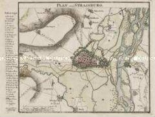
Plan von Strassburg

Landkarte aus der Serie "Berlin und Umgebung", Blatt 2: Oranienburg
![Umgebungskarte von Potsdam, 1:40 000, Kupferstich, 1798 : Plan von der Insel Potsdam und deren Stadt-Gebiet / Frentzel sc.. - [Ca. 1:40 000]. - Nicht ermittelbar, 1798. - 1 Karte : Kupferstich ; 43 x 43 cm // Maßstab in graph. Form (Rheinl. Ruthen). - Ohne Kt.-Netz](https://iiif.deutsche-digitale-bibliothek.de/image/2/71937dfe-e6b4-4a80-8bf3-b4cfa35e2d42/full/!306,450/0/default.jpg)
Umgebungskarte von Potsdam, 1:40 000, Kupferstich, 1798 : Plan von der Insel Potsdam und deren Stadt-Gebiet / Frentzel sc.. - [Ca. 1:40 000]. - Nicht ermittelbar, 1798. - 1 Karte : Kupferstich ; 43 x 43 cm // Maßstab in graph. Form (Rheinl. Ruthen). - Ohne Kt.-Netz

Topographische Karte der Région Centre zwischen St. Calais, Tour, Blois, Vierzon und Orléans

Plan der Stadt Antwerpen

Karte von Franken mit Ansicht von Thurnau
Der LEIPZIGER KREIS zu finden in Leipzig bey Schreiber Erben
Karte der Amtshauptmannschaften Dresden, Freiberg, Prina, Großenhain und Bautzen, Kupferstich, um 1830 : Die Gegend um Dresden. - Circa 1:218.500. - Leipzig : bei Schreiber's Erben,[1830?]. - 1 Karte : handkolorierter Kupferstich ; 28 cm Durchmesser, Blattgröße 38 x 49 cm // Maßstab in grafischer Form: 1 Deutsche Meile, 15 auf 1 Grad
Nouveau Plan des Environs de Paris
Karte der Schlacht bei Dresden am 26 und 27 August 1813, ca. 1:30 000, Kupferstich, 1849 : Plan de la Bataille de Dresde 26 et 27 Août 1813, et Théâtre des Manœuvres. Des Armées Prussienne et Autrichiennes sur les bords de l'Elbe, depuis Schandau jusqu'à Nider-Warta, pendant les Guerres du 18e. siècle / Dressé au Dépôt Général de la Guerre, sous la Direction du Gén[ér]al de Div[isi]on Pelet. - Fotokopie d. Kupferst. Paris 1849.. - [Ca. 1:30 000] Paris , 2012. - 1 Kt. in 4 Bl. : einfarb. ; je Bl. 70 x 45 cm. - Mit Lehmannschen Schraffen, wahrschl. dienten die Sächs. Meilenblätter als Grundlage für d. Kupferstich
Übersichtsplan vom Inundationsgebiete der Gewässer bei und in der Umgegend von Leipzig.
Nova Comitatus Pappenheimensis. Mit einer Nebenkarte: Herrschafft Bellenberg; und einer Ansicht: Stadt Pappenheim
Plan von Strassburg
Landkarte aus der Serie "Berlin und Umgebung", Blatt 2: Oranienburg
Umgebungskarte von Potsdam, 1:40 000, Kupferstich, 1798 : Plan von der Insel Potsdam und deren Stadt-Gebiet / Frentzel sc.. - [Ca. 1:40 000]. - Nicht ermittelbar, 1798. - 1 Karte : Kupferstich ; 43 x 43 cm // Maßstab in graph. Form (Rheinl. Ruthen). - Ohne Kt.-Netz
Topographische Karte der Région Centre zwischen St. Calais, Tour, Blois, Vierzon und Orléans
Plan der Stadt Antwerpen