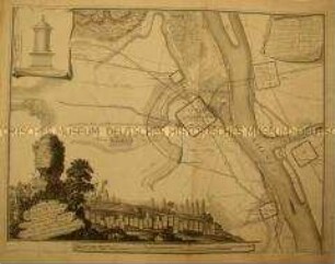
- Location
-
Deutsches Historisches Museum, Berlin
- Inventory number
-
Do 2006/390
- Measurements
-
Höhe x Breite: 37,2 x 48 cm (Blatt)
Höhe x Breite: 28,4 x 33,6 cm (Karte)
Höhe x Breite: 30 x 38,6 cm (Platte)
- Material/Technique
-
Druckfarbe, Papier, Kupferstich, koloriert
- Classification
-
Kartografie (Gattung)
- Subject (what)
-
Straßburg
- Event
-
Herstellung
- (who)
-
Stecher: Karl Friedrich Müller
Verleger: J. B. Klein
Kartograf: Franz Ludwig Güssefeld
- (where)
-
Leipzig, Deutschland
- (when)
-
1793
- Rights
-
Deutsches Historisches Museum
- Last update
-
24.03.2023, 9:28 AM CET
Data provider
This object is provided by:
Stiftung Deutsches Historisches Museum. If you have any questions about the object, please contact the data provider.
Stiftung Deutsches Historisches Museum. If you have any questions about the object, please contact the data provider.
Object type
- Umgebungskarte
Associated
- Stecher: Karl Friedrich Müller
- Verleger: J. B. Klein
- Kartograf: Franz Ludwig Güssefeld
Time of origin
- 1793
Other Objects (12)

Plan der Stadt Antwerpen

Plan von Köln und Umgebung (Schweid). Um 1610

Nouveau Plan des Environs de Paris
Comparaison Du Plan De L'Ancien Magontiacum Avec La Situation Actuelle De La Ville De Mayence
![Umgebungskarte von Potsdam, 1:40 000, Kupferstich, 1798 : Plan von der Insel Potsdam und deren Stadt-Gebiet / Frentzel sc.. - [Ca. 1:40 000]. - Nicht ermittelbar, 1798. - 1 Karte : Kupferstich ; 43 x 43 cm // Maßstab in graph. Form (Rheinl. Ruthen). - Ohne Kt.-Netz](https://iiif.deutsche-digitale-bibliothek.de/image/2/71937dfe-e6b4-4a80-8bf3-b4cfa35e2d42/full/!306,450/0/default.jpg)
Umgebungskarte von Potsdam, 1:40 000, Kupferstich, 1798 : Plan von der Insel Potsdam und deren Stadt-Gebiet / Frentzel sc.. - [Ca. 1:40 000]. - Nicht ermittelbar, 1798. - 1 Karte : Kupferstich ; 43 x 43 cm // Maßstab in graph. Form (Rheinl. Ruthen). - Ohne Kt.-Netz
![Umgebungplan von Meißen , Federzeichnung, um 1780 : Situations-Plan der Stadt Meissen : und der umliegenden Gegend / mit der Bousole und nach Schritten aufgenommen von Carl Gottlob Kühlemann. - [Ca. 1:11 000]. - [S.l.] , [um 1780]. - 1 Kt. : Federzeichnung ; 54 x 37 cm. - Maßstab in graph. Form (Schritt). - Mit Gebäudeverz. und Höhenschraffen](https://iiif.deutsche-digitale-bibliothek.de/image/2/de841af9-beba-4350-b388-52c2a54554a6/full/!306,450/0/default.jpg)
Umgebungplan von Meißen , Federzeichnung, um 1780 : Situations-Plan der Stadt Meissen : und der umliegenden Gegend / mit der Bousole und nach Schritten aufgenommen von Carl Gottlob Kühlemann. - [Ca. 1:11 000]. - [S.l.] , [um 1780]. - 1 Kt. : Federzeichnung ; 54 x 37 cm. - Maßstab in graph. Form (Schritt). - Mit Gebäudeverz. und Höhenschraffen

Leipzig und Umgebung, Kupferstich, 1800 : Plan von der umliegenden Gegend bey Leipzig / J. G. L.. - Nicht ermittelbar, 1800. - 1 Karte : Kupferstich ; 19 x 26 cm, Blattgröße 32 x 36 cm // Mit 1 Nebenkarte unter dem Titel: Durchschnit der Erd u. Kohlenschichten in der Sandgrube

Karte von Franken mit Ansicht von Thurnau

Landkarte der Umgebung von Berlin
Topographische Karte der Umgebung von Berlin
![Karte der Schlacht bei Dresden am 26 und 27 August 1813, ca. 1:30 000, Kupferstich, 1849 : Plan de la Bataille de Dresde 26 et 27 Août 1813, et Théâtre des Manœuvres. Des Armées Prussienne et Autrichiennes sur les bords de l'Elbe, depuis Schandau jusqu'à Nider-Warta, pendant les Guerres du 18e. siècle / Dressé au Dépôt Général de la Guerre, sous la Direction du Gén[ér]al de Div[isi]on Pelet. - Fotokopie d. Kupferst. Paris 1849.. - [Ca. 1:30 000] Paris , 2012. - 1 Kt. in 4 Bl. : einfarb. ; je Bl. 70 x 45 cm. - Mit Lehmannschen Schraffen, wahrschl. dienten die Sächs. Meilenblätter als Grundlage für d. Kupferstich](https://iiif.deutsche-digitale-bibliothek.de/image/2/a61d20f2-195e-4620-8449-40ffa735515f/full/!306,450/0/default.jpg)
Karte der Schlacht bei Dresden am 26 und 27 August 1813, ca. 1:30 000, Kupferstich, 1849 : Plan de la Bataille de Dresde 26 et 27 Août 1813, et Théâtre des Manœuvres. Des Armées Prussienne et Autrichiennes sur les bords de l'Elbe, depuis Schandau jusqu'à Nider-Warta, pendant les Guerres du 18e. siècle / Dressé au Dépôt Général de la Guerre, sous la Direction du Gén[ér]al de Div[isi]on Pelet. - Fotokopie d. Kupferst. Paris 1849.. - [Ca. 1:30 000] Paris , 2012. - 1 Kt. in 4 Bl. : einfarb. ; je Bl. 70 x 45 cm. - Mit Lehmannschen Schraffen, wahrschl. dienten die Sächs. Meilenblätter als Grundlage für d. Kupferstich
![Karte der Schlacht bei Dresden am 26 und 27 August 1813, ca. 1:30 000, Kupferstich, 1849 : Plan de la Bataille de Dresde 26 et 27 Août 1813, et Théâtre des Manœuvres. Des Armées Prussienne et Autrichiennes sur les bords de l'Elbe, depuis Schandau jusqu'à Nider-Warta, pendant les Guerres du 18e. siècle / Dressé au Dépôt Général de la Guerre, sous la Direction du Gén[ér]al de Div[isi]on Pelet. - Fotokopie d. Kupferst. Paris 1849.. - [Ca. 1:30 000] Paris , 2012. - 1 Kt. in 4 Bl. : einfarb. ; je Bl. 70 x 45 cm. - Mit Lehmannschen Schraffen, wahrschl. dienten die Sächs. Meilenblätter als Grundlage für d. Kupferstich](https://iiif.deutsche-digitale-bibliothek.de/image/2/93b4a1e2-cff8-482e-bdfd-d5da50e7c7b5/full/!306,450/0/default.jpg)
Karte der Schlacht bei Dresden am 26 und 27 August 1813, ca. 1:30 000, Kupferstich, 1849 : Plan de la Bataille de Dresde 26 et 27 Août 1813, et Théâtre des Manœuvres. Des Armées Prussienne et Autrichiennes sur les bords de l'Elbe, depuis Schandau jusqu'à Nider-Warta, pendant les Guerres du 18e. siècle / Dressé au Dépôt Général de la Guerre, sous la Direction du Gén[ér]al de Div[isi]on Pelet. - Fotokopie d. Kupferst. Paris 1849.. - [Ca. 1:30 000] Paris , 2012. - 1 Kt. in 4 Bl. : einfarb. ; je Bl. 70 x 45 cm. - Mit Lehmannschen Schraffen, wahrschl. dienten die Sächs. Meilenblätter als Grundlage für d. Kupferstich
Plan der Stadt Antwerpen
Plan von Köln und Umgebung (Schweid). Um 1610
Nouveau Plan des Environs de Paris
Comparaison Du Plan De L'Ancien Magontiacum Avec La Situation Actuelle De La Ville De Mayence
Umgebungskarte von Potsdam, 1:40 000, Kupferstich, 1798 : Plan von der Insel Potsdam und deren Stadt-Gebiet / Frentzel sc.. - [Ca. 1:40 000]. - Nicht ermittelbar, 1798. - 1 Karte : Kupferstich ; 43 x 43 cm // Maßstab in graph. Form (Rheinl. Ruthen). - Ohne Kt.-Netz
Umgebungplan von Meißen , Federzeichnung, um 1780 : Situations-Plan der Stadt Meissen : und der umliegenden Gegend / mit der Bousole und nach Schritten aufgenommen von Carl Gottlob Kühlemann. - [Ca. 1:11 000]. - [S.l.] , [um 1780]. - 1 Kt. : Federzeichnung ; 54 x 37 cm. - Maßstab in graph. Form (Schritt). - Mit Gebäudeverz. und Höhenschraffen
Leipzig und Umgebung, Kupferstich, 1800 : Plan von der umliegenden Gegend bey Leipzig / J. G. L.. - Nicht ermittelbar, 1800. - 1 Karte : Kupferstich ; 19 x 26 cm, Blattgröße 32 x 36 cm // Mit 1 Nebenkarte unter dem Titel: Durchschnit der Erd u. Kohlenschichten in der Sandgrube
Karte von Franken mit Ansicht von Thurnau
Landkarte der Umgebung von Berlin
Topographische Karte der Umgebung von Berlin
Karte der Schlacht bei Dresden am 26 und 27 August 1813, ca. 1:30 000, Kupferstich, 1849 : Plan de la Bataille de Dresde 26 et 27 Août 1813, et Théâtre des Manœuvres. Des Armées Prussienne et Autrichiennes sur les bords de l'Elbe, depuis Schandau jusqu'à Nider-Warta, pendant les Guerres du 18e. siècle / Dressé au Dépôt Général de la Guerre, sous la Direction du Gén[ér]al de Div[isi]on Pelet. - Fotokopie d. Kupferst. Paris 1849.. - [Ca. 1:30 000] Paris , 2012. - 1 Kt. in 4 Bl. : einfarb. ; je Bl. 70 x 45 cm. - Mit Lehmannschen Schraffen, wahrschl. dienten die Sächs. Meilenblätter als Grundlage für d. Kupferstich
Karte der Schlacht bei Dresden am 26 und 27 August 1813, ca. 1:30 000, Kupferstich, 1849 : Plan de la Bataille de Dresde 26 et 27 Août 1813, et Théâtre des Manœuvres. Des Armées Prussienne et Autrichiennes sur les bords de l'Elbe, depuis Schandau jusqu'à Nider-Warta, pendant les Guerres du 18e. siècle / Dressé au Dépôt Général de la Guerre, sous la Direction du Gén[ér]al de Div[isi]on Pelet. - Fotokopie d. Kupferst. Paris 1849.. - [Ca. 1:30 000] Paris , 2012. - 1 Kt. in 4 Bl. : einfarb. ; je Bl. 70 x 45 cm. - Mit Lehmannschen Schraffen, wahrschl. dienten die Sächs. Meilenblätter als Grundlage für d. Kupferstich
Plan der Stadt Antwerpen
Plan von Köln und Umgebung (Schweid). Um 1610
Nouveau Plan des Environs de Paris
Comparaison Du Plan De L'Ancien Magontiacum Avec La Situation Actuelle De La Ville De Mayence
Umgebungskarte von Potsdam, 1:40 000, Kupferstich, 1798 : Plan von der Insel Potsdam und deren Stadt-Gebiet / Frentzel sc.. - [Ca. 1:40 000]. - Nicht ermittelbar, 1798. - 1 Karte : Kupferstich ; 43 x 43 cm // Maßstab in graph. Form (Rheinl. Ruthen). - Ohne Kt.-Netz
Umgebungplan von Meißen , Federzeichnung, um 1780 : Situations-Plan der Stadt Meissen : und der umliegenden Gegend / mit der Bousole und nach Schritten aufgenommen von Carl Gottlob Kühlemann. - [Ca. 1:11 000]. - [S.l.] , [um 1780]. - 1 Kt. : Federzeichnung ; 54 x 37 cm. - Maßstab in graph. Form (Schritt). - Mit Gebäudeverz. und Höhenschraffen
Leipzig und Umgebung, Kupferstich, 1800 : Plan von der umliegenden Gegend bey Leipzig / J. G. L.. - Nicht ermittelbar, 1800. - 1 Karte : Kupferstich ; 19 x 26 cm, Blattgröße 32 x 36 cm // Mit 1 Nebenkarte unter dem Titel: Durchschnit der Erd u. Kohlenschichten in der Sandgrube
Karte von Franken mit Ansicht von Thurnau
Landkarte der Umgebung von Berlin
Topographische Karte der Umgebung von Berlin
Karte der Schlacht bei Dresden am 26 und 27 August 1813, ca. 1:30 000, Kupferstich, 1849 : Plan de la Bataille de Dresde 26 et 27 Août 1813, et Théâtre des Manœuvres. Des Armées Prussienne et Autrichiennes sur les bords de l'Elbe, depuis Schandau jusqu'à Nider-Warta, pendant les Guerres du 18e. siècle / Dressé au Dépôt Général de la Guerre, sous la Direction du Gén[ér]al de Div[isi]on Pelet. - Fotokopie d. Kupferst. Paris 1849.. - [Ca. 1:30 000] Paris , 2012. - 1 Kt. in 4 Bl. : einfarb. ; je Bl. 70 x 45 cm. - Mit Lehmannschen Schraffen, wahrschl. dienten die Sächs. Meilenblätter als Grundlage für d. Kupferstich