Karten / Pläne
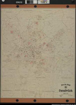
Osnabrück (Osnabrück) Stadtplan mit 4 Bezirken 1948 1 : 10 000 111 x 92 Druck: Willy Größchen, Dortmund Städtisches Vermessungsamt Bem.: Bedeutung der 4 Bezirke nicht ersichtlich
- Reference number
-
W 051, 20175
- Further information
-
Ort: Osnabrück, Osnabrück
- Context
-
Karten A (Allgemein) >> 1. Topographische Karte, Übersichtskarten >> 1.5. Stadt-/ Ortspläne
- Holding
-
W 051 Karten A (Allgemein)
- Indexentry place
-
Osnabrück, Osnabrück
Osnabrück, Stadtplan, 1948
- Provenance
-
Sammlungsregistraturbildner
- Date of creation
-
1948
- Other object pages
- Delivered via
- Last update
-
24.06.2025, 1:56 PM CEST
Data provider
This object is provided by:
Landesarchiv Nordrhein-Westfalen. Abteilung Westfalen. If you have any questions about the object, please contact the data provider.
Landesarchiv Nordrhein-Westfalen. Abteilung Westfalen. If you have any questions about the object, please contact the data provider.
Object type
- Karten / Pläne
Associated
- Sammlungsregistraturbildner
Time of origin
- 1948
Other Objects (12)
Plan der Stadt Osnabrück. Ausf.-Art: Farbige Zeichnung auf Papier Herst.: Willy Größchen, Städt. Vermessungsamt Osnabrück Format: 115 x 95 cm Maßstab: 1 : 10000

Rednereinsatz im Bezirk Osnabrück
Plan der Stadt Osnabrück 5. Auflage Ausf.-Art: Druck auf Karton, durch Willy Größchen, Dortmund Hersteller: Städtisches Vermessungsamt Osnabrück Format: 113,8 x 94,4 cm Maßstab: 1 : 10000
Landeskirchliche Gemeinschaft - Bezirk Osnabrück, auch: Evangelische Allianz Osnabrück, Jugendbund für entschiedenes Christentum Osnabrück
"Karte des Landdrostei Bezirks Osnabrück"
"Karte des Landdrostei Bezirks Osnabrück"
Grösschen, Anton
Arbeitsgerichte im Bezirk des Landesarbeitsgerichtsbezirks Osnabrück
Zollneubauten.- Nordhorn (Bezirk), Reg. Bez. Osnabrück
Forst- und Jagdpolizei im Bezirk Osnabrück
Stadtplan Osnabrück, bearbeitet vom Städtischen Vermessungsamt Osnabrück Ausgabe 1976/77 Ausf.-Art: Farbdruck auf Papier Hersteller: Städtisches Vermessungsamt Osnabrück Format: 53,5 x 68,5 cm Maßstab: 1 : 30000
Quadt und Hüchtenbruck, Freiherr v. Landrat des Kreises Osnabrück, Reg.-Bezirk Osnabrück
Plan der Stadt Osnabrück. Ausf.-Art: Farbige Zeichnung auf Papier Herst.: Willy Größchen, Städt. Vermessungsamt Osnabrück Format: 115 x 95 cm Maßstab: 1 : 10000
Rednereinsatz im Bezirk Osnabrück
Plan der Stadt Osnabrück 5. Auflage Ausf.-Art: Druck auf Karton, durch Willy Größchen, Dortmund Hersteller: Städtisches Vermessungsamt Osnabrück Format: 113,8 x 94,4 cm Maßstab: 1 : 10000
Landeskirchliche Gemeinschaft - Bezirk Osnabrück, auch: Evangelische Allianz Osnabrück, Jugendbund für entschiedenes Christentum Osnabrück
"Karte des Landdrostei Bezirks Osnabrück"
"Karte des Landdrostei Bezirks Osnabrück"
Grösschen, Anton
Arbeitsgerichte im Bezirk des Landesarbeitsgerichtsbezirks Osnabrück
Zollneubauten.- Nordhorn (Bezirk), Reg. Bez. Osnabrück
Forst- und Jagdpolizei im Bezirk Osnabrück
Stadtplan Osnabrück, bearbeitet vom Städtischen Vermessungsamt Osnabrück Ausgabe 1976/77 Ausf.-Art: Farbdruck auf Papier Hersteller: Städtisches Vermessungsamt Osnabrück Format: 53,5 x 68,5 cm Maßstab: 1 : 30000