- Alternativer Titel
-
Bodensee - Gesehen von einem Satelliten aus 800 km Höhe
- Standort
-
Deutsches Historisches Museum, Berlin
- Inventarnummer
-
P 2000/232
- Maße
-
Höhe x Breite: 59,4 x 84 cm
- Material/Technik
-
Papier, Offset
- Klassifikation
-
Druckgraphik (Gattung)
- Bezug (was)
-
Luftbild
Satellit
Karte
Topographie
Bodensee
- Ereignis
-
Herstellung
- (wer)
-
Fotoatelier: Dornier Satellitensysteme GmbH Erdbeobachtungs-Datenservice
- (wo)
-
Friedrichshafen, Deutschland
- (wann)
-
1996
- Rechteinformation
-
Deutsches Historisches Museum
- Letzte Aktualisierung
-
24.03.2023, 09:28 MEZ
Datenpartner
Dieses Objekt wird bereitgestellt von:
Stiftung Deutsches Historisches Museum. Bei Fragen zum Objekt wenden Sie sich bitte an den Datenpartner.
Stiftung Deutsches Historisches Museum. Bei Fragen zum Objekt wenden Sie sich bitte an den Datenpartner.
Objekttyp
- Plakat
Beteiligte
- Fotoatelier: Dornier Satellitensysteme GmbH Erdbeobachtungs-Datenservice
Entstanden
- 1996
Ähnliche Objekte (12)

Die Fischerin vom Bodensee

Auf Wiedersehen am Bodensee

Zum Bodensee! Der Löwe von Lindau/ Bayern
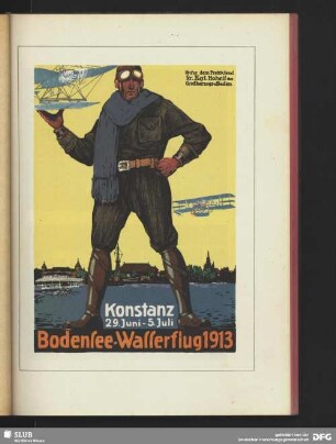
Bodensee-Wasserflug

Reklameplakat für die Schülerakademie 2009 - Einblick mit Ausblick - von der Zeppelin Universität in Friedrichshafen am Bodensee vom 4. bis 8. August 2009

ADAC Bodensee Sportwoche

Reiseverkehrswerbung für den Bodensee
Plakat zur 4. Internationalen Bodensee-Messe Friedrichshafen
Plakat zu Festwochen in Konstanz am Bodensee
Werbeplakat für die schweizerische Schiffahrt auf dem Bodensee

Vom blauen Himmel

Neues vom Hexer
Die Fischerin vom Bodensee
Auf Wiedersehen am Bodensee
Zum Bodensee! Der Löwe von Lindau/ Bayern
Bodensee-Wasserflug
Reklameplakat für die Schülerakademie 2009 - Einblick mit Ausblick - von der Zeppelin Universität in Friedrichshafen am Bodensee vom 4. bis 8. August 2009
ADAC Bodensee Sportwoche
Reiseverkehrswerbung für den Bodensee
Plakat zur 4. Internationalen Bodensee-Messe Friedrichshafen
Plakat zu Festwochen in Konstanz am Bodensee
Werbeplakat für die schweizerische Schiffahrt auf dem Bodensee
Vom blauen Himmel