Karten / Pläne
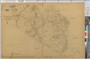
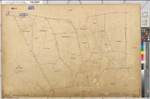
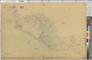
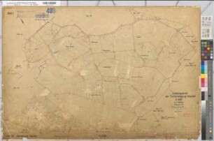
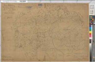
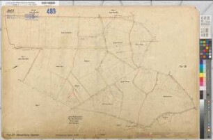
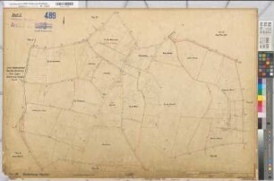
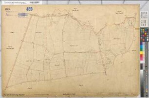
Hopsten? (Hopsten) Grundstück Poppensieker Lageplan mit Höhenaufnahme 1969 1 : 1000 43 x 74 Pause Ingenieurbüro Pasche Regierung Münster Nr. 34070
- Former reference number
-
Regierung Münster 34070
- Further information
-
Ort: Hopsten, Hopsten
- Context
-
Karten A (Allgemein) >> 2. Land- und Forstwirtschaft >> 2.1. Ländereien >> 2.1.1. A-K
- Holding
-
W 051 Karten A (Allgemein)
- Indexentry person
-
Poppensieker, Hopsten, 1969
- Indexentry place
-
Hopsten, Hopsten
Hopsten, Poppensieker, Ländereien, 1969
- Provenance
-
Sammlungsregistraturbildner
- Date of creation
-
1969
- Other object pages
- Delivered via
- Last update
-
24.06.2025, 1:13 PM CEST
Data provider
This object is provided by:
Landesarchiv Nordrhein-Westfalen. Abteilung Westfalen. If you have any questions about the object, please contact the data provider.
Landesarchiv Nordrhein-Westfalen. Abteilung Westfalen. If you have any questions about the object, please contact the data provider.
Object type
- Karten / Pläne
Associated
- Sammlungsregistraturbildner
Time of origin
- 1969
Other Objects (12)
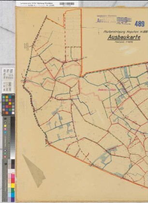
Hopsten (Hopsten), Flurbereinigung Hopsten, Aufbaukarte
Hopsten (Hopsten), Flurbereinigung Hopsten, Schätzungskarte Planblatt 3
Hopsten (Hopsten), Flurbereinigung Hopsten, Schätzungskarte Flur 11
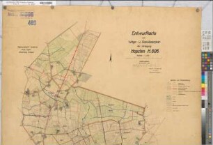
Hopsten (Hopsten), Flurbereinigung Hopsten, Wege- und Gewässerplan
Hopsten (Hopsten), Flurbereinigung Hopsten, Schätzungskarte Planblatt 2
Hopsten (Hopsten), Flurbereinigung Hopsten, Bl.3 Zuteilungskarte Flur 24
Hopsten (Hopsten), Flurbereinigung Hopsten, Schätzungskarte Planblatt 5,2
Hopsten (Hopsten), Flurbereinigung Hopsten, Bl.1 Zuteilungskarte Flur 22
Hopsten (Hopsten), Flurbereinigung Hopsten, Schätzungskarte Flur 4,2
Hopsten (Hopsten), Flurbereinigung Hopsten, Bl.6 Zuteilungskarte Flur 27
Hopsten (Hopsten), Flurbereinigung Hopsten, Bl.5 Zuteilungskarte Flur 26
Hopsten (Hopsten), Flurbereinigung Hopsten, Bl.4 Zuteilungskarte Flur 25
Hopsten (Hopsten), Flurbereinigung Hopsten, Aufbaukarte
Hopsten (Hopsten), Flurbereinigung Hopsten, Schätzungskarte Planblatt 3
Hopsten (Hopsten), Flurbereinigung Hopsten, Schätzungskarte Flur 11
Hopsten (Hopsten), Flurbereinigung Hopsten, Wege- und Gewässerplan
Hopsten (Hopsten), Flurbereinigung Hopsten, Schätzungskarte Planblatt 2
Hopsten (Hopsten), Flurbereinigung Hopsten, Bl.3 Zuteilungskarte Flur 24
Hopsten (Hopsten), Flurbereinigung Hopsten, Schätzungskarte Planblatt 5,2
Hopsten (Hopsten), Flurbereinigung Hopsten, Bl.1 Zuteilungskarte Flur 22
Hopsten (Hopsten), Flurbereinigung Hopsten, Schätzungskarte Flur 4,2
Hopsten (Hopsten), Flurbereinigung Hopsten, Bl.6 Zuteilungskarte Flur 27
Hopsten (Hopsten), Flurbereinigung Hopsten, Bl.5 Zuteilungskarte Flur 26