topographische Karten
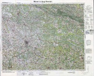
Karte des Gebietes von Münster i. Westf., Iburg und Warendorf
- Alternative title
-
Reichskarte Einheitsblatt 71
- Location
-
Deutsches Historisches Museum, Berlin
- Inventory number
-
Do 83/41I
- Measurements
-
Höhe x Breite: 64,5 x 79,5 cm
- Material/Technique
-
Papier, gedruckt
- Classification
-
Karten, Pläne, Risse (Gattung)
- Subject (what)
-
Topographie
Deutschland
- Event
-
Herstellung
- (who)
-
Herausgeber: Verlag des Reichsamts für Landesaufnahme
- (where)
-
Berlin, Deutschland [historisch: Deutsches Reich]
- (when)
-
1930
- Rights
-
Deutsches Historisches Museum
- Last update
-
24.03.2023, 9:29 AM CET
Data provider
This object is provided by:
Stiftung Deutsches Historisches Museum. If you have any questions about the object, please contact the data provider.
Stiftung Deutsches Historisches Museum. If you have any questions about the object, please contact the data provider.
Object type
- topographische Karten
Associated
- Herausgeber: Verlag des Reichsamts für Landesaufnahme
Time of origin
- 1930
Other Objects (12)

Karte Münster i.W. - Iburg - Warendorf
![Münster, Iburg, Warendorf, topographische Karte: [Karte des Deutschen Reiches]. Einheitsblatt Nr. 71 ( 1 cm-Karte). Münster i.W. - Iburg - Warendorf.](https://iiif.deutsche-digitale-bibliothek.de/image/2/8cac690d-00a5-4a28-b354-429f5bf72401/full/!306,450/0/default.jpg)
Münster, Iburg, Warendorf, topographische Karte: [Karte des Deutschen Reiches]. Einheitsblatt Nr. 71 ( 1 cm-Karte). Münster i.W. - Iburg - Warendorf.
Warendorf / Westf.- Finanzamt
Reichskarte: Einheitsblatt 71 (1cm-Karte) Münster i. W.-Iburg-Warendorf
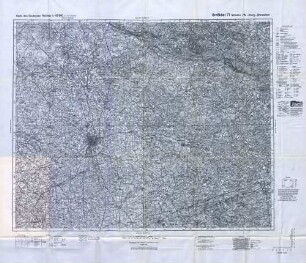
Reichskarte: Großblatt 71 Münster i. W.-Iburg-Warendorf
Karte des Deutschen Reiches 1 : 100000 (1-cm-Karte) / Großblatt 771 Münster i. W. - Iburg - Warendorf
Zur Stratigraphie und Sedimentologie der Grünsandsteine zwischen Iburg und Halle/Westf[alen]
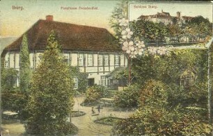
Iburg. Forsthaus Freudenthal. Schloss Iburg.
Verbreitung parasitärer Tierkrankheiten im Kreise Warendorf/Westf.
Iburg
Iburg
Iburg
Karte Münster i.W. - Iburg - Warendorf
Münster, Iburg, Warendorf, topographische Karte: [Karte des Deutschen Reiches]. Einheitsblatt Nr. 71 ( 1 cm-Karte). Münster i.W. - Iburg - Warendorf.
Warendorf / Westf.- Finanzamt
Reichskarte: Einheitsblatt 71 (1cm-Karte) Münster i. W.-Iburg-Warendorf
Reichskarte: Großblatt 71 Münster i. W.-Iburg-Warendorf
Karte des Deutschen Reiches 1 : 100000 (1-cm-Karte) / Großblatt 771 Münster i. W. - Iburg - Warendorf
Zur Stratigraphie und Sedimentologie der Grünsandsteine zwischen Iburg und Halle/Westf[alen]
Iburg. Forsthaus Freudenthal. Schloss Iburg.
Verbreitung parasitärer Tierkrankheiten im Kreise Warendorf/Westf.
Iburg
Iburg