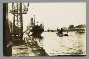
Die Fahrwasserbezeichnung des Danziger Hafens
Abstract: Due to the morphological circumstances of their locations, the aspiring port settlements and maritime towns on the southern coast of the Baltic Sea were compelled at an early date to indicate their entrances with nautical marks. The entrance to Gdansk often shifted due to changes in the courses of the Vistula and Motlawa. There is documentary evidence of the channel having been marked by a beacon since the thirteenth century, but the practise presumably began as early as the ninth or tenth centuries. In the course of the centuries, a long series of beacons were erected, adapting to both the shifting channels and the ongoing technical advancements. In the mid eighteenth century, through the erection of the two towers of Nowy Port, the very first range light system on the southern Baltic Sea coast was established. From the early seventeenth century on, the channels in the Gdansk Bay were also lit: by the beacons of Cape Rozewie and Hela in the west and those of Pillau and Krynica Mor
- Weitere Titel
-
The channel markings of the port of Gdansk
- Standort
-
Deutsche Nationalbibliothek Frankfurt am Main
- Umfang
-
Online-Ressource
- Sprache
-
Deutsch
- Anmerkungen
-
Veröffentlichungsversion
nicht begutachtet
In: Deutsches Schiffahrtsarchiv ; 25 (2002) ; 269-286
- Klassifikation
-
Handel, Kommunikation, Verkehr
- Schlagwort
-
Fahrwasser
Hafen
Leuchtturm
Turm
Danzig
Danziger Bucht
- URN
-
urn:nbn:de:0168-ssoar-55912-0
- Rechteinformation
-
Open Access unbekannt; Open Access; Der Zugriff auf das Objekt ist unbeschränkt möglich.
- Letzte Aktualisierung
-
15.08.2025, 07:37 MESZ
Datenpartner
Deutsche Nationalbibliothek. Bei Fragen zum Objekt wenden Sie sich bitte an den Datenpartner.
Beteiligte
Entstanden
- 2002
Ähnliche Objekte (12)

Am Danziger Hafen

Die Fahrwasserbezeichnung des Danziger Hafens

Zehnjährige Entwicklung des Danziger Hafens

Im Danziger Hafen am Hokladeplatz
Vor der Westerplatte im Danziger Hafen
Polen, Medaille 10 Jahre Danziger Hafen
Wasserbauten am Danziger Hafen, Bd. 1
Wasserbauten am Danziger Hafen, Bd. 2
Wasserbauten am Danziger Hafen, Bd. 3
Danziger Hafen : Danzig (Gdansk/Polen). Hafen an der Alten Festung
Die Forderung von Gewerbesteuern im Danziger Hafen

Düker im Danziger Hafen, Deutschland, ohne Datum
Am Danziger Hafen
Die Fahrwasserbezeichnung des Danziger Hafens
Zehnjährige Entwicklung des Danziger Hafens
Im Danziger Hafen am Hokladeplatz
Vor der Westerplatte im Danziger Hafen
Polen, Medaille 10 Jahre Danziger Hafen
Wasserbauten am Danziger Hafen, Bd. 1
Wasserbauten am Danziger Hafen, Bd. 2
Wasserbauten am Danziger Hafen, Bd. 3
Danziger Hafen : Danzig (Gdansk/Polen). Hafen an der Alten Festung
Die Forderung von Gewerbesteuern im Danziger Hafen