Altkarte
Accurater Grundris und Gegend der Hoch-Fürstl. Brandenb. Bayreuth. Neu-Erbauten Stadt Christian-Erlang : samt denen Prospecten des Hoch-Furstl. Residenz-Schloß und anderer ansehnlichen Gebäuen, wie auch der nach ihrem fatalen Brand wieder gantz aufgebauten Neuen Alt-Stadt Erlang; Cum Privilegio Sac. Caes. Majestatis
- Alternative title
-
Accurater Grundris und Gegend der Hoch-Fürstlich Brandenb. Bayreuth. Neu-Erbauten Stadt Christian-Erlang
- Location
-
München, Bayerische Staatsbibliothek -- 2 Mapp. 76 a
- Dimensions
-
32 x 33 cm, Bildgr. 57 x 48 cm
- Extent
-
1 Plan
- Language
-
Deutsch
- Notes
-
Kupferstich
Mit 7 Ansichten. - Titelkartusche oben Mitte
- Bibliographic citation
-
Homann, Johann B.: Grosser Atlas Uber die Gantze Welt ; 57
- Keyword
-
Schlosspark
Grundriss
Vedute
Erlangen
Schloss Erlangen
- Event
-
Veröffentlichung
- (where)
-
Nürnb.//Nürnberg//
- (when)
-
s.a. [nach 1715]
- Contributor
- URN
-
urn:nbn:de:bvb:12-bsb00015959-7
- Last update
-
16.04.2025, 8:31 AM CEST
Data provider
This object is provided by:
Bayerische Staatsbibliothek. If you have any questions about the object, please contact the data provider.
Bayerische Staatsbibliothek. If you have any questions about the object, please contact the data provider.
Object type
- Altkarte
Associated
Time of origin
- s.a. [nach 1715]
Other Objects (12)

Erlang
Erlang

Beck-Erlang
Beck-Erlang, Wilfried
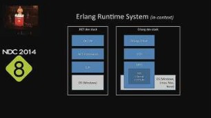
CQRS with Erlang
Erlang, vom Januar
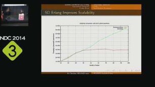
RELEASE Scalable Erlang
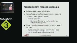
Wherefore art thou Erlang?
Egloffstein, Grafen von; Erlang
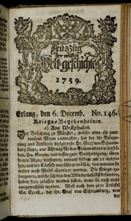
Erlang, den 6 Decemb. No. 146. - Erlang, den 15. Decem. No. 150.
Stadtmauerbau in Erlangen (Christian Erlang)
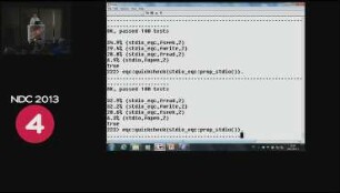
Certifying your car with Erlang
Erlang
Erlang
Beck-Erlang
Beck-Erlang, Wilfried
CQRS with Erlang
Erlang, vom Januar
RELEASE Scalable Erlang
Wherefore art thou Erlang?
Egloffstein, Grafen von; Erlang
Erlang, den 6 Decemb. No. 146. - Erlang, den 15. Decem. No. 150.
Stadtmauerbau in Erlangen (Christian Erlang)