Archivale
Admiral-Scheer-Straße
Längenprofil und Lageplan von der Skagerrakstraße bis zur Gorch-Fock-Straße.
- Reference number
-
Slg-KUP, A 134,16,4
- Dimensions
-
Bi.: 44 x 41,7; Bl. 46,5 x 46,3
- Formal description
-
Papier leicht geknickt.
- Notes
-
Zeichner/Verfasser: Hdt.
- Further information
-
Ausführung: Pause
Maßstab: 1:100, 1:1000
- Context
-
Karten und Pläne >> 01. Stadtdarstellungen >> 01.04. Straßen und Plätze
- Holding
-
Slg-KUP Karten und Pläne
- Indexentry person
-
Hdt
Leh
- Indexentry place
-
Admiral-Scheer-Straße
- Date of creation
-
1936, 06. 11.
- Other object pages
- Provenance
-
. Städtisches Tiefbauamt
- Delivered via
- Last update
-
05.11.2025, 3:38 PM CET
Data provider
This object is provided by:
Stadtarchiv Münster. If you have any questions about the object, please contact the data provider.
Stadtarchiv Münster. If you have any questions about the object, please contact the data provider.
Object type
- Archivale
Time of origin
- 1936, 06. 11.
Other Objects (12)

Admiral-Scheer-Straße (Feldstraße)
Straßensicherung: Admiral-Scheer-Straße
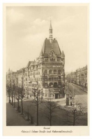
Kassel Admiral-Scheer-Straße
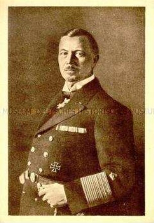
Admiral Scheer
Admiral Scheer
Admiral-Scheer-Brücke
Admiral-Scheer-Brücke
Marinekameradschaft "Admiral Scheer"
Marinekameradschaft "Admiral Scheer"
Marinekameradschaft "Admiral Scheer"
Feldstraße (vorher Admiral-Scheer-Straße): Grunderwerb
Feldstraße (vorher Admiral-Scheer-Straße): Fluchtlinienfestsetzung
Admiral-Scheer-Straße (Feldstraße)
Straßensicherung: Admiral-Scheer-Straße
Kassel Admiral-Scheer-Straße
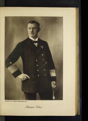
Admiral Scheer
Admiral Scheer
Admiral-Scheer-Brücke
Admiral-Scheer-Brücke
Marinekameradschaft "Admiral Scheer"
Marinekameradschaft "Admiral Scheer"
Marinekameradschaft "Admiral Scheer"
Feldstraße (vorher Admiral-Scheer-Straße): Grunderwerb
Feldstraße (vorher Admiral-Scheer-Straße): Fluchtlinienfestsetzung
Admiral-Scheer-Straße (Feldstraße)
Straßensicherung: Admiral-Scheer-Straße
Kassel Admiral-Scheer-Straße
Admiral Scheer
Admiral Scheer
Admiral-Scheer-Brücke
Admiral-Scheer-Brücke
Marinekameradschaft "Admiral Scheer"
Marinekameradschaft "Admiral Scheer"
Marinekameradschaft "Admiral Scheer"
Feldstraße (vorher Admiral-Scheer-Straße): Grunderwerb