Karten / Pläne
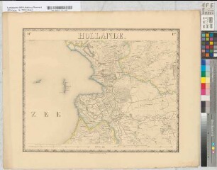
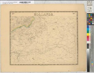
[Nouvelle Carte de la] Hollande [, d'apres Krayenhoff et les meilleures cartes connues. 24 feuilles.] Etablissement Géographique de Bruxelles [, Fondé par Ph. Vander Maelen, Blatt] 24: Düsseldorf
- Reference number
-
RW Karten, 10044
- Dimensions
-
Höhe: 55 cm, Breite: 68 cm, Maßstab: [ca. 1: 115 200]
- Notes
-
Wie RW Karten Nr. 7233, jedoch vollständig; Mittelfalz oben eingerissen und mit Filmoplast hinterlegt, leicht gebräunt, sonst tadellos - Ankauf vom Antiquariat Nikolaus Struck / Clemens Paulusch, Berlin, im November 2022, aus: Katalog 230 (2020), Nr. 78 (datiert um 1830) (Akz. 2022/198)
- Context
-
RW Karten >> 1. Topographische Karten >> 1.3. Landesaufnahme Ausland >> 1.3.3. Europa >> 1.3.3.1. Niederlande
- Holding
-
RW Karten
- Provenance
-
Diverse Registraturbildner
- Date of creation
-
[ca. 1825]
- Other object pages
- Delivered via
- Last update
-
24.06.2025, 1:17 PM CEST
Data provider
This object is provided by:
Landesarchiv Nordrhein-Westfalen. Abteilung Rheinland. If you have any questions about the object, please contact the data provider.
Landesarchiv Nordrhein-Westfalen. Abteilung Rheinland. If you have any questions about the object, please contact the data provider.
Object type
- Karten / Pläne
Associated
- Diverse Registraturbildner
Time of origin
- [ca. 1825]
Other Objects (12)
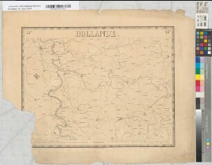
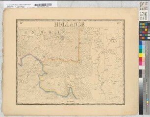
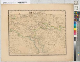
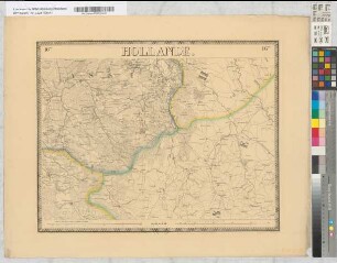
Nouvelle Carte de la Hollande, d'apres Krayenhoff et les meilleures cartes connues. 24 feuilles. Etablissement Géographique de Bruxelles, Fondé par Ph. Vander Maelen. Blatt 24. Düsseldorf.
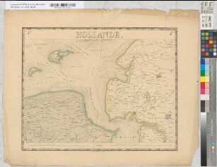
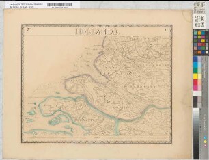
Nouvelle Carte de la Hollande, d'apres Krayenhoff et les meilleures cartes connues. 24 feuilles. Etablissement Géographique de Bruxelles, Fondé par Ph. Vander Maelen. Blatt 12.Koeverden.
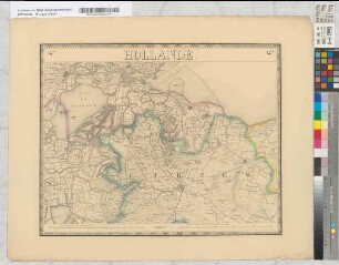
Nouvelle Carte de la Hollande, d'apres Krayenhoff et les meilleures cartes connues. 24 feuilles. Etablissement Géographique de Bruxelles, Fondé par Ph. Vander Maelen. Blatt 19. Arnhem.
Nouvelle Carte de la Hollande, d'apres Krayenhoff et les meilleures cartes connues. 24 feuilles. Etablissement Géographique de Bruxelles, Fondé par Ph. Vander Maelen. Blatt 16. Oldenzaal.
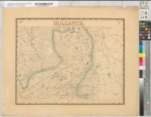
Nouvelle Carte de la Hollande, d'apres Krayenhoff et les meilleures cartes connues. 24 feuilles. Etablissement Géographique de Bruxelles, Fondé par Ph. Vander Maelen. Blatt 11. Zwolle.
Nouvelle Carte de la Hollande, d'apres Krayenhoff et les meilleures cartes connues. 24 feuilles. Etablissement Géographique de Bruxelles, Fondé par Ph. Vander Maelen. Blatt 4. Emden.
Nouvelle Carte de la Hollande, d'apres Krayenhoff et les meilleures cartes connues. 24 feuilles. Etablissement Géographique de Bruxelles, Fondé par Ph. Vander Maelen. Blatt 14. Utrecht.
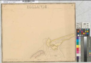
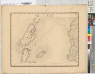
Nouvelle Carte de la Hollande, d'apres Krayenhoff et les meilleures cartes connues. 24 feuilles. Etablissement Géographique de Bruxelles, Fondé par Ph. Vander Maelen. Blatt 2. Vlieland
Nouvelle Carte de la Hollande, d'apres Krayenhoff et les meilleures cartes connues. 24 feuilles. Etablissement Géographique de Bruxelles, Fondé par Ph. Vander Maelen. Blatt 20. Wesel.
Nouvelle Carte de la Hollande, d'apres Krayenhoff et les meilleures cartes connues. 24 feuilles. Etablissement Géographique de Bruxelles, Fondé par Ph. Vander Maelen. Blatt 17. Brielle.
Nouvelle Carte de la Hollande, d'apres Krayenhoff et les meilleures cartes connues. 24 feuilles. Etablissement Géographique de Bruxelles, Fondé par Ph. Vander Maelen. Blatt 6. Texel.
Nouvelle Carte de la Hollande, d'apres Krayenhoff et les meilleures cartes connues. 24 feuilles. Etablissement Géographique de Bruxelles, Fondé par Ph. Vander Maelen. Blatt 23. Helmont.
Nouvelle Carte de la Hollande, d'apres Krayenhoff et les meilleures cartes connues. 24 feuilles. Etablissement Géographique de Bruxelles, Fondé par Ph. Vander Maelen. Blatt 24. Düsseldorf.
Nouvelle Carte de la Hollande, d'apres Krayenhoff et les meilleures cartes connues. 24 feuilles. Etablissement Géographique de Bruxelles, Fondé par Ph. Vander Maelen. Blatt 12.Koeverden.
Nouvelle Carte de la Hollande, d'apres Krayenhoff et les meilleures cartes connues. 24 feuilles. Etablissement Géographique de Bruxelles, Fondé par Ph. Vander Maelen. Blatt 19. Arnhem.
Nouvelle Carte de la Hollande, d'apres Krayenhoff et les meilleures cartes connues. 24 feuilles. Etablissement Géographique de Bruxelles, Fondé par Ph. Vander Maelen. Blatt 16. Oldenzaal.
Nouvelle Carte de la Hollande, d'apres Krayenhoff et les meilleures cartes connues. 24 feuilles. Etablissement Géographique de Bruxelles, Fondé par Ph. Vander Maelen. Blatt 11. Zwolle.
Nouvelle Carte de la Hollande, d'apres Krayenhoff et les meilleures cartes connues. 24 feuilles. Etablissement Géographique de Bruxelles, Fondé par Ph. Vander Maelen. Blatt 4. Emden.
Nouvelle Carte de la Hollande, d'apres Krayenhoff et les meilleures cartes connues. 24 feuilles. Etablissement Géographique de Bruxelles, Fondé par Ph. Vander Maelen. Blatt 14. Utrecht.
Nouvelle Carte de la Hollande, d'apres Krayenhoff et les meilleures cartes connues. 24 feuilles. Etablissement Géographique de Bruxelles, Fondé par Ph. Vander Maelen. Blatt 2. Vlieland
Nouvelle Carte de la Hollande, d'apres Krayenhoff et les meilleures cartes connues. 24 feuilles. Etablissement Géographique de Bruxelles, Fondé par Ph. Vander Maelen. Blatt 20. Wesel.
Nouvelle Carte de la Hollande, d'apres Krayenhoff et les meilleures cartes connues. 24 feuilles. Etablissement Géographique de Bruxelles, Fondé par Ph. Vander Maelen. Blatt 17. Brielle.
Nouvelle Carte de la Hollande, d'apres Krayenhoff et les meilleures cartes connues. 24 feuilles. Etablissement Géographique de Bruxelles, Fondé par Ph. Vander Maelen. Blatt 6. Texel.