Karten / Pläne
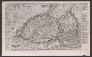
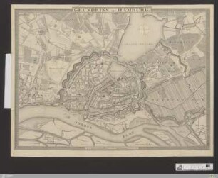
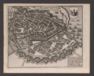
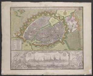
Hamburg (Hamburg) Stadtplan um 1800 Einzeichnung in Stadtplan von 1965 mit Erläuterungen 1967 1 : 5000 44 x 60 farb. Druck: Vermessungsamt Hamburg Ferdinand Facklam; Carl-Otto Fleischhauer B Nr. 1250
- Former reference number
-
B 1250
- Further information
-
Ort: Hamburg, Hamburg
- Context
-
Karten A (Allgemein) >> 1. Topographische Karte, Übersichtskarten >> 1.5. Stadt-/ Ortspläne
- Holding
-
W 051 Karten A (Allgemein)
- Indexentry place
-
Hamburg, Hamburg
Hamburg, Stadtplan, 1967
- Provenance
-
Sammlungsregistraturbildner
- Date of creation
-
1967
- Other object pages
- Delivered via
- Last update
-
24.06.2025, 2:03 PM CEST
Data provider
This object is provided by:
Landesarchiv Nordrhein-Westfalen. Abteilung Westfalen. If you have any questions about the object, please contact the data provider.
Landesarchiv Nordrhein-Westfalen. Abteilung Westfalen. If you have any questions about the object, please contact the data provider.
Object type
- Karten / Pläne
Associated
- Sammlungsregistraturbildner
Time of origin
- 1967
Other Objects (12)
Hamburg, Stadtplan
Stadtplan Hamburg
Stadtplan Hamburg
Hamburg, Stadtplan

"Stadtplan von Hamburg"
"Stadtplan von Hamburg"
Stadtplan von Hamburg
"Stadtplan von Hamburg"
![Hamburg 1936 : [Stadtplan]](https://iiif.deutsche-digitale-bibliothek.de/image/2/67d015df-33c9-4bf0-b1c0-f138699ecf11/full/!306,450/0/default.jpg)
Hamburg 1936 : [Stadtplan]
Stadtplan von Hamburg
![Hansestadt Hamburg : [Stadtplan]](https://iiif.deutsche-digitale-bibliothek.de/image/2/87c7119f-04ae-4b42-b585-08ff8727e3e1/full/!306,450/0/default.jpg)
Hansestadt Hamburg : [Stadtplan]
Hamburg, Stadtplan und -ansicht
Hamburg, Stadtplan
Stadtplan Hamburg
Stadtplan Hamburg
Hamburg, Stadtplan
"Stadtplan von Hamburg"
"Stadtplan von Hamburg"
Stadtplan von Hamburg
"Stadtplan von Hamburg"
Hamburg 1936 : [Stadtplan]
Stadtplan von Hamburg
Hansestadt Hamburg : [Stadtplan]
Hamburg, Stadtplan und -ansicht
Hamburg, Stadtplan
Stadtplan Hamburg
Stadtplan Hamburg
Hamburg, Stadtplan
"Stadtplan von Hamburg"
"Stadtplan von Hamburg"
Stadtplan von Hamburg
"Stadtplan von Hamburg"
Hamburg 1936 : [Stadtplan]
Stadtplan von Hamburg
Hansestadt Hamburg : [Stadtplan]