Karten / Pläne
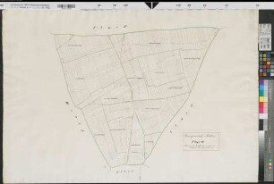
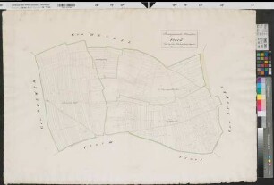
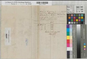
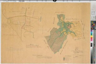
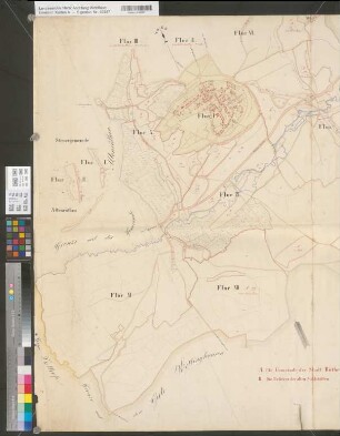
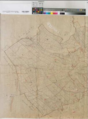
Rüthen (Rüthen) Katasterkarte, Flur 3 1833 1 : 2500 71 x 102 kol. Zeichnung, Kopie kopiert: Dickmann KSA Nr. 707
- Former reference number
-
Kartensammlung Arnsberg 707
- Further information
-
Ort: Rüthen, Rüthen
- Context
-
Karten A (Allgemein) >> 2. Land- und Forstwirtschaft >> 2.2. Katasterkarten
- Holding
-
W 051 Karten A (Allgemein)
- Indexentry place
-
Rüthen, Rüthen
Rüthen, Flurkarte, 1833
- Provenance
-
Sammlungsregistraturbildner
- Date of creation
-
1833
- Other object pages
- Delivered via
- Last update
-
24.06.2025, 1:47 PM CEST
Data provider
This object is provided by:
Landesarchiv Nordrhein-Westfalen. Abteilung Westfalen. If you have any questions about the object, please contact the data provider.
Landesarchiv Nordrhein-Westfalen. Abteilung Westfalen. If you have any questions about the object, please contact the data provider.
Object type
- Karten / Pläne
Associated
- Sammlungsregistraturbildner
Time of origin
- 1833
Other Objects (12)
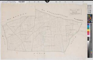
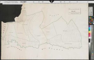
Rüthen (Rüthen) Katasterkarte, Flur 2 1833 1 : 2500 71 x 102 kol. Zeichnung, Kopie kopiert: Dickmann KSA Nr. 713
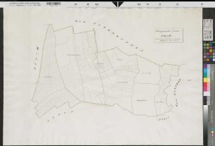
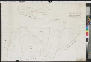
Rüthen (Rüthen) Katasterkarte, Flur 4 1833 1 : 2500 71 x 102 kol. Zeichnung, Kopie kopiert: Dickmann KSA Nr. 714
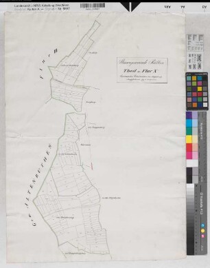
Drewer (Rüthen) Katasterkarte Flur IV 1833 1 : 2500 71 x 102 kol. Zeichnung, Kopie kopiert: Dickmann KSA Nr. 712
Altenrüthen (Rüthen) Katasterkarte Flur III 1833 1 : 2500 71 x 102 kol. Zeichnung, Kopie kopiert: Dickmann KSA Nr. 710
Altenrüthen (Rüthen) Katasterkarte Flur IV 1833 1 : 2500 71 x 102 kol. Zeichnung, Kopie kopiert: Dickmann KSA Nr. 706
Altenrüthen (Rüthen) Katasterkarte Flur II 1833 1 : 2500 71 x 102 kol. Zeichnung, Kopie kopiert: Dickmann Bem.: beschädigt KSA Nr. 708
Menzel (Rüthen) Katasterkarte Teile der Fluren 1 und 2 1833 1 : 2500 71 x 102 kol. Zeichnung kopiert: Dickmann KSA Nr. 709
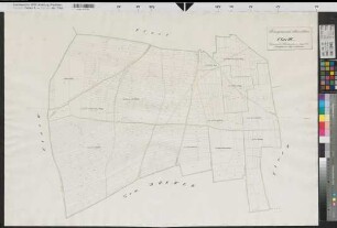
Rüthen (Rüthen) Katasterkarte, Teil der Flur 10 1833 1 : 2500 70 x 51 kol. Zeichnung kopiert: Diekmann KSA Nr. 715
Rüthen (Rüthen) - Kallenhardt (Rüthen) Beschreibung der neuen Grenze in den Mönningkörben 1817 Heft Holzapfel KSA (138)
Rüthen (Rüthen), Hudebefreiung Rüthen, Brouillonkarte
Rüthen (Rüthen), Gemeinheitsteilung Rüthen, Übersichtskarte
Rüthen (Rüthen), Separation Rüthen, Übersichtskarte
Rüthen (Rüthen) Katasterkarte, Flur 2 1833 1 : 2500 71 x 102 kol. Zeichnung, Kopie kopiert: Dickmann KSA Nr. 713
Rüthen (Rüthen) Katasterkarte, Flur 4 1833 1 : 2500 71 x 102 kol. Zeichnung, Kopie kopiert: Dickmann KSA Nr. 714
Drewer (Rüthen) Katasterkarte Flur IV 1833 1 : 2500 71 x 102 kol. Zeichnung, Kopie kopiert: Dickmann KSA Nr. 712
Altenrüthen (Rüthen) Katasterkarte Flur III 1833 1 : 2500 71 x 102 kol. Zeichnung, Kopie kopiert: Dickmann KSA Nr. 710
Altenrüthen (Rüthen) Katasterkarte Flur IV 1833 1 : 2500 71 x 102 kol. Zeichnung, Kopie kopiert: Dickmann KSA Nr. 706
Altenrüthen (Rüthen) Katasterkarte Flur II 1833 1 : 2500 71 x 102 kol. Zeichnung, Kopie kopiert: Dickmann Bem.: beschädigt KSA Nr. 708
Menzel (Rüthen) Katasterkarte Teile der Fluren 1 und 2 1833 1 : 2500 71 x 102 kol. Zeichnung kopiert: Dickmann KSA Nr. 709
Rüthen (Rüthen) Katasterkarte, Teil der Flur 10 1833 1 : 2500 70 x 51 kol. Zeichnung kopiert: Diekmann KSA Nr. 715
Rüthen (Rüthen) - Kallenhardt (Rüthen) Beschreibung der neuen Grenze in den Mönningkörben 1817 Heft Holzapfel KSA (138)
Rüthen (Rüthen), Hudebefreiung Rüthen, Brouillonkarte
Rüthen (Rüthen), Gemeinheitsteilung Rüthen, Übersichtskarte