- Alternative title
-
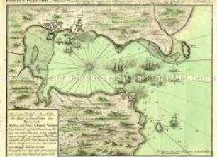
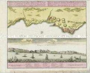
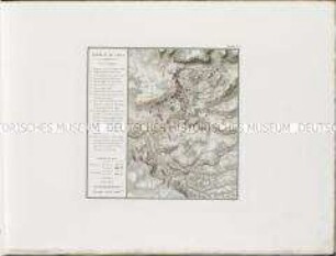
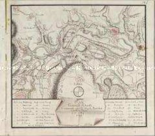
PORTUS PULCHRI, in Isthmo Panamensi siti accurata Ichnographia ex prototypo Lodinensi, desumta. / prostat in Officina Homanniana 1740. cum Privil. S. Caes. Majest.
- Location
-
Deutsches Historisches Museum, Berlin
- Inventory number
-
Do 2006/839
- Measurements
-
Höhe x Breite: 64,5 x 55 cm (Blatt)
Höhe x Breite: 20,5 x 28,2 cm (Karte 1)
Höhe x Breite: 24,6 x 29,7 cm (Platte 1)
Höhe x Breite: 23 x 28 cm (Karte 2)
Höhe x Breite: 24,6 x 29,2 cm (Platte 2)
- Material/Technique
-
Papier, Kupferstich, koloriert
- Classification
-
Kartografie (Gattung)
- Subject (what)
-
Panama
- Event
-
Herstellung
- (who)
-
Kartograf: Philip Durell
Kartograf: James Rentone
Verlag: Homannsche Erben
- (where)
-
London Nürnberg
- (when)
-
1740
- Rights
-
Deutsches Historisches Museum
- Last update
-
24.03.2023, 9:27 AM CET
Data provider
This object is provided by:
Stiftung Deutsches Historisches Museum. If you have any questions about the object, please contact the data provider.
Stiftung Deutsches Historisches Museum. If you have any questions about the object, please contact the data provider.
Object type
- Schlachtenkarte
Associated
- Kartograf: Philip Durell
- Kartograf: James Rentone
- Verlag: Homannsche Erben
Time of origin
- 1740
Other Objects (12)
#Portus Pulchri in Isthmo Panamensi/ Grundriß der Stadt Portobelo, des Hafens und der Forts 1740
Topographica Repraesentatio Barbarici Portus et Urbis Munitae Oran. Mit einer Ansicht: Prospect von der Küste um Oran

Plan de la Bataille d'Abukir
The operations of his Majesty's Squadron in the bay of Honduras / The attack and escalade on the 20th of October 1779 of San Fernando de Omoa. Mit einer Nebenkarte: Plan of the Fort
Ordre de Bataille de l'Armée Impériale, à la Bataille de Kolin, le 18. Juin, 1757.

Combat de Reichenberg
Schlachtenkarte: Plan de la Battaille de Creveld, 23 Juni 1758
Bataille de Valls

Ergänzungsblatt zu: Plan von den Stellungen der Arméen am 20ten September 1792 bei Valmy
Plan du Camp de Schurtz
Karten und Plane zur Kriegsgeschichte von Bayern: Hohenlinden mit seiner Umgebung

Position des Toute les deux Armée en Bohéme de l'Anné 1778 / Positionen der beiden Armeen in Böhmen im Jahr 1778
#Portus Pulchri in Isthmo Panamensi/ Grundriß der Stadt Portobelo, des Hafens und der Forts 1740
Topographica Repraesentatio Barbarici Portus et Urbis Munitae Oran. Mit einer Ansicht: Prospect von der Küste um Oran
Plan de la Bataille d'Abukir
The operations of his Majesty's Squadron in the bay of Honduras / The attack and escalade on the 20th of October 1779 of San Fernando de Omoa. Mit einer Nebenkarte: Plan of the Fort
Ordre de Bataille de l'Armée Impériale, à la Bataille de Kolin, le 18. Juin, 1757.
Combat de Reichenberg
Schlachtenkarte: Plan de la Battaille de Creveld, 23 Juni 1758
Bataille de Valls
Ergänzungsblatt zu: Plan von den Stellungen der Arméen am 20ten September 1792 bei Valmy
Plan du Camp de Schurtz
Karten und Plane zur Kriegsgeschichte von Bayern: Hohenlinden mit seiner Umgebung