Grafik | Landkarte
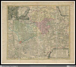
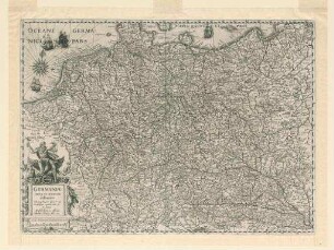
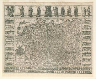
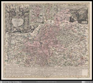
Delineatio geographica generalis
Historische Landkarte von Mainfranken zwischen Mainz und Würzburg mit kolorierten Grenzhervorhebungen.
- Alternative title
-
comprehendens 6 foliis sungulos principatus ... omnes, quotquot imperio ... landgrafii Hasso-Darmstadiensis subsunt
- Collection
-
Pictothek
- Identifier
-
36/A 1.29
- Source
-
Universitätsbibliothek Würzburg
- Language
-
Latein
- Subject
-
Altkarte
- Subject (where)
-
Spessart
Main
Mainfranken
Hessen
Darmstadt
- Event
-
Geistige Schöpfung
- (who)
- (when)
-
1754
- Event
-
Veröffentlichung
- (who)
- URN
-
urn:nbn:de:bvb:20-36a129term73544254-2
- Last update
-
06.03.2025, 3:26 PM CET
Data provider
This object is provided by:
Universitätsbibliothek Würzburg. If you have any questions about the object, please contact the data provider.
Universitätsbibliothek Würzburg. If you have any questions about the object, please contact the data provider.
Object type
- Grafik
- Landkarte
Time of origin
- 1754
Other Objects (12)

Delineatio geographica generalis
Territorii Sacri Romani Imperii liberae civitatis Norimbergensis nova et accurata delineatio geographica et topographica

Atlas Poloniae (Ukraina), Delineatio Generalis Camporum Desertorum vulgo
Nova Poloniae delineatio
Tabula geographica dioecesis Fuldensis
Tabula geographica ducatus Würtemberg
Germaniae nova accurata delineatio
Tabula geographica provinciarum Brabantiae, Geldriae...
Germaniae nova et accurata delineatio
Ducatus Silesiae Glogani vera delineatio
Tabula geographica novissima principalis episcopatus Bambergensis
Mappa geographica exhibens Principatum Brandenburgico-Onolsbacensem
Delineatio geographica generalis
Territorii Sacri Romani Imperii liberae civitatis Norimbergensis nova et accurata delineatio geographica et topographica
Atlas Poloniae (Ukraina), Delineatio Generalis Camporum Desertorum vulgo
Nova Poloniae delineatio
Tabula geographica dioecesis Fuldensis
Tabula geographica ducatus Würtemberg
Germaniae nova accurata delineatio
Tabula geographica provinciarum Brabantiae, Geldriae...
Germaniae nova et accurata delineatio
Ducatus Silesiae Glogani vera delineatio
Tabula geographica novissima principalis episcopatus Bambergensis