Karten / Pläne
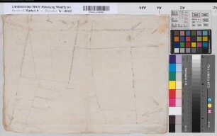
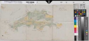
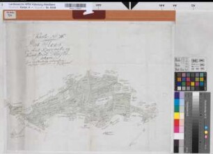
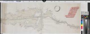
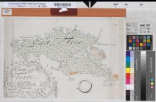
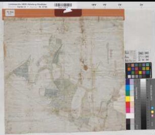
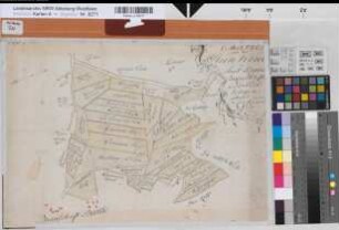
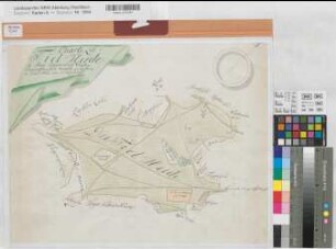
Hörste (Halle) Vermessung des Nordbruchs 1772 o.M. 48,5 x 70 kol. Zeichnung M. Christian Ludolf Reinhold Spez.Verz. Markenkarten X Nr. 71
- Reference number
-
W 051, 8315
- Former reference number
-
Markenkarten X 71
- Further information
-
Ort: Hörste, Halle
- Context
-
Karten A (Allgemein) >> 2. Land- und Forstwirtschaft >> 2.3. Markenkarten >> 2.3.1. A-K
- Holding
-
W 051 Karten A (Allgemein)
- Indexentry place
-
Hörste, Halle
Hörste, Nordbruch, Markenteilung, 1772
Nordbruch, Markenteilung s. Hörste, 1772
- Provenance
-
Sammlungsregistraturbildner
- Date of creation
-
1772
- Other object pages
- Delivered via
- Last update
-
30.04.2025, 3:00 PM CEST
Data provider
This object is provided by:
Landesarchiv Nordrhein-Westfalen. Abteilung Westfalen. If you have any questions about the object, please contact the data provider.
Landesarchiv Nordrhein-Westfalen. Abteilung Westfalen. If you have any questions about the object, please contact the data provider.
Object type
- Karten / Pläne
Associated
- Sammlungsregistraturbildner
Time of origin
- 1772
Other Objects (12)
Hörste (Halle) Vermessungslinien im Barrelsbusch (1801) o.M. 31 x 43 Zeichnung Spez.Verz. Markenkarten X Nr. 74b
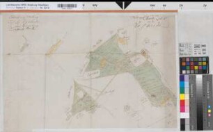
Hörste (Halle) Teilung des Gehölzes Fleer Entwurf 1791 o.M. 31 x 62 kol. Zeichnung Reinhold Spez.Verz. Markenkarten X Nr. 70

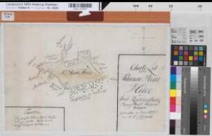
Hörste (Halle) Teilung des Nordbruchs Entwurf (1780) o.M. (1 : 2400) 25 x 38,5 Zeichnung (Reinhold) Spez.Verz. Markenkarten X Nr. 72
Hörste (Halle) Teilung des Fleers 1787 o.M. 43 x 56 kol. Zeichnung M. C. L. Reinhold Spez.Verz. Markenkarten X Nr. 67
Hörste (Halle) Vermessung der Fleersheide 1772 o.M. 43 x 113 kol. Zeichnung M. Chr. Lud. Reinhold Spez.Verz. Markenkarten X Nr. 68
Hörste (Halle) Vermessung des Fleers 1772 o.M. 33 x 49,5 kol. Zeichnung M. Christ. Lud. Reinhold Spez.Verz. Markenkarten X Nr. 66
Schweicheln (Hiddenhausen) Gemeinheit Falkendiek 1794 200 Ruten = 14,8 cm 46 x 48,5 kol. Zeichnung H. G. Pohlmeyer Spez.Verz. Markenkarten II Nr. 7
Valdorf (Vlotho) Vermessung des Beerenkämpener Krichenhofes Entwurf 1815 o.M. (1 : 4000) 43 x 48,5 kol. Zeichnung (Friemel) Spez.Verz. Markenkarten XVI Nr. 3
Bokel (Halle) Teilung der Steinheide 1775 o.M. 33,5 x 48,5 kol. Zeichnung M. C. L. Reinhold Spez.Verz. Markenkarten X Nr. 87
Borgholzhausen (Borgholzhausen) Vermessung der Tielheide 1772 ca 1 : 3750 42 x 54 kol. Zeichnung M. Reinhold Markenkarten Spez.Verz. Markenkarten X Nr. 17a
Hesseln (Halle) Vermessung der Kleinen Steinheide 1773 o.M. 32,5 x 48,5 kol. Zeichnung M. C. L. Reinhold Spez.Verz. Markenkarten X Nr. 49
Hörste (Halle) Teilungsentwurf der Voß(Foss)- und Riesheide nach 1788 o.M. 42 x 64 kol. Zeichnung (M. Reinhold) Spez.Verz. Markenkarten X Nr. 78,2
Hörste (Halle) Vermessungslinien im Barrelsbusch (1801) o.M. 31 x 43 Zeichnung Spez.Verz. Markenkarten X Nr. 74b
Hörste (Halle) Teilung des Gehölzes Fleer Entwurf 1791 o.M. 31 x 62 kol. Zeichnung Reinhold Spez.Verz. Markenkarten X Nr. 70
Hörste (Halle) Teilung des Nordbruchs Entwurf (1780) o.M. (1 : 2400) 25 x 38,5 Zeichnung (Reinhold) Spez.Verz. Markenkarten X Nr. 72
Hörste (Halle) Teilung des Fleers 1787 o.M. 43 x 56 kol. Zeichnung M. C. L. Reinhold Spez.Verz. Markenkarten X Nr. 67
Hörste (Halle) Vermessung der Fleersheide 1772 o.M. 43 x 113 kol. Zeichnung M. Chr. Lud. Reinhold Spez.Verz. Markenkarten X Nr. 68
Hörste (Halle) Vermessung des Fleers 1772 o.M. 33 x 49,5 kol. Zeichnung M. Christ. Lud. Reinhold Spez.Verz. Markenkarten X Nr. 66
Schweicheln (Hiddenhausen) Gemeinheit Falkendiek 1794 200 Ruten = 14,8 cm 46 x 48,5 kol. Zeichnung H. G. Pohlmeyer Spez.Verz. Markenkarten II Nr. 7
Valdorf (Vlotho) Vermessung des Beerenkämpener Krichenhofes Entwurf 1815 o.M. (1 : 4000) 43 x 48,5 kol. Zeichnung (Friemel) Spez.Verz. Markenkarten XVI Nr. 3
Bokel (Halle) Teilung der Steinheide 1775 o.M. 33,5 x 48,5 kol. Zeichnung M. C. L. Reinhold Spez.Verz. Markenkarten X Nr. 87
Borgholzhausen (Borgholzhausen) Vermessung der Tielheide 1772 ca 1 : 3750 42 x 54 kol. Zeichnung M. Reinhold Markenkarten Spez.Verz. Markenkarten X Nr. 17a
Hesseln (Halle) Vermessung der Kleinen Steinheide 1773 o.M. 32,5 x 48,5 kol. Zeichnung M. C. L. Reinhold Spez.Verz. Markenkarten X Nr. 49