Altkarte
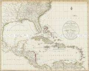
Colton's map of the United States of America, the British provinces, Mexico and the West Indies : showing the country from the Atlantic to the Pacific Ocean
Kurzbeschreibung: Einzelkarte
Kartographische Angaben: Nullmeridian Washington und Greenwich
- Standort
-
Greifswald
- Sammlung
-
Kartensammlung des Instituts für Geographie und Geologie (Universität Greifswald)
- Inventarnummer
-
AltK/T10.00/1
- Maße
-
135 x 150 cm
Maßstab [ca. 1:3,500,000]
- Material/Technik
-
Papierartig; geschnitten; auf Leinen gezogen
- Inschrift/Beschriftung
-
Verantwortlichkeitsangabe: published by J.H. Colton
- Klassifikation
-
Kartographie
- Bezug (wo)
-
New York
- Ereignis
-
Herstellung
- (wann)
-
1853
- Letzte Aktualisierung
-
25.03.2025, 09:46 MEZ
Datenpartner
Dieses Objekt wird bereitgestellt von:
Universität Greifswald. Kartensammlung des Instituts für Geographie und Geologie. Bei Fragen zum Objekt wenden Sie sich bitte an den Datenpartner.
Universität Greifswald. Kartensammlung des Instituts für Geographie und Geologie. Bei Fragen zum Objekt wenden Sie sich bitte an den Datenpartner.
Objekttyp
- Altkarte
Entstanden
- 1853
Ähnliche Objekte (12)
With the American Fleet from the Atlantic to the Pacific
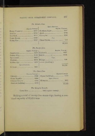
The Atlantic Line. The Pacific Line. The China Line. The Shanghai Branch.
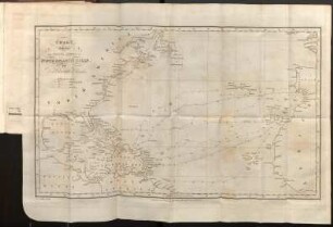
Chart shewing The Tracks across the North Atlantic Ocean. Chart of the West Indies.
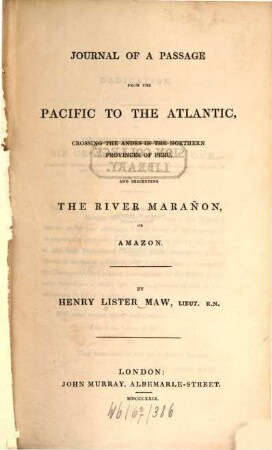
Journal of a Passage from the Pacific to the Atlantic

Postwar : art between the Pacific and the Atlantic 1945-1965

Maps of the Pacific and Atlantic areas

Connecting Atlantic and Pacific : theorizing the Arctic
Into the indies

The East Indies
The west Indies
The West Indies

The west Indies
With the American Fleet from the Atlantic to the Pacific
The Atlantic Line. The Pacific Line. The China Line. The Shanghai Branch.
Chart shewing The Tracks across the North Atlantic Ocean. Chart of the West Indies.
Journal of a Passage from the Pacific to the Atlantic
Postwar : art between the Pacific and the Atlantic 1945-1965
Maps of the Pacific and Atlantic areas
Connecting Atlantic and Pacific : theorizing the Arctic
Into the indies
The East Indies
The west Indies
The West Indies
The west Indies
With the American Fleet from the Atlantic to the Pacific
The Atlantic Line. The Pacific Line. The China Line. The Shanghai Branch.
Chart shewing The Tracks across the North Atlantic Ocean. Chart of the West Indies.
Journal of a Passage from the Pacific to the Atlantic
Postwar : art between the Pacific and the Atlantic 1945-1965
Maps of the Pacific and Atlantic areas
Connecting Atlantic and Pacific : theorizing the Arctic
Into the indies
The East Indies
The west Indies
The West Indies