Regionalkarte
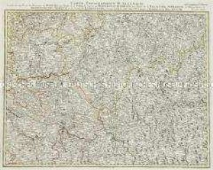
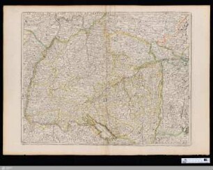
Grand Atlas . Bl. 67 (Schwaben,Schweiz): Contenant une Partie de Suabe de la Suisse savoir les Cantons de Schafhausen, de Zurich, et d'Appenzell et et une Partie de Schwarzwald le Comté de Baaden et le Thurgau.
- Alternative title
-
CARTE TOPOGRAPHIQUE D'ALLEMAGNE / Contenant une Partie de SUABE de la SUISSE savoir les CANTONS de SCHAFHAUSEN, de ZURICH, et d'APPENZELL et et une Partie de SCHWARZWALD le / COMTÉ de BAADEN et le THURGAU.
- Location
-
Deutsches Historisches Museum, Berlin
- Inventory number
-
Do 2006/1059.67
- Measurements
-
Höhe x Breite: 56,5 x 78 cm, Höhe: 56,5 cm, Breite: 78 cm, Tiefe: 3 cm (Atlas)
Höhe x Breite: 56,5 x 78 cm (Blatt)
Höhe x Breite: 52 x 68 cm (Platte)
Höhe x Breite: 46 x 59 cm (Karte)
- Material/Technique
-
Papier, Kupferstich, koloriert, gebunden |Fadenheftung
- Classification
-
Kartografie (Gattung)
- Subject (what)
-
Deutschland
- Event
-
Herstellung
- (who)
-
Verleger, Militärkartograph: Johann Wilhelm Abraham Jaeger
- (where)
-
Frankfurt (Main) [historisch: Frankfurt, Reichsstadt], Deutschland
- (when)
-
um 1787
- Rights
-
Deutsches Historisches Museum
- Last update
-
24.03.2023, 9:30 AM CET
Data provider
This object is provided by:
Stiftung Deutsches Historisches Museum. If you have any questions about the object, please contact the data provider.
Stiftung Deutsches Historisches Museum. If you have any questions about the object, please contact the data provider.
Object type
- Regionalkarte
Associated
- Verleger, Militärkartograph: Johann Wilhelm Abraham Jaeger
Time of origin
- um 1787
Other Objects (12)
Grand Atlas . Bl. 42 (Böhmen, Sachsen...): Contenant une Partie du Royaume de Boheme, une Partie de la Saxe, le Cercle de Montagnes D'Airain, une Partie de la Palatine Superieur, le Margraviat de Brandenbourg Bareut, et le Comte de Lobenstein et et

42: Carte Topographique De L'Allemagne Contenant une Partie du Royaume de Boheme, une Partie de la Saxe, le Cercle de Montagnes D'Airain, une Partie de la Palatine Superieur, le Margraviat de Brandenbourg-Bareut, et le Comte de Lobenstein &&
Grand Atlas . Bl. 32 (Thüringen, Hessen...): Contenante Une Partie du Cercle de Thuringen Orientale, une Partie de la Hesse, les Principautés de Gotta, Elsenach et une Partie du Schwartzburg, les Comtes de Stollberg Mansfeld et Hatzfeld, le Territoire d'Erfurt, le Pais de Eichsfeld et le Territoire de Muhlhausen

Grand Atlas . Bl. 41 (Würzburg, Bamberg Fulda,Coburg...): Contenant une Partie de l'Evêchés de Wurtzbourg et Bamberg et de Fulde les Duchés de Saxe Coburg, Gotha, Meinungen, Hildbourgshausen et une Partie de Saxe Weimar, le Comté de Schwartzbourg, le Baillage de Smalcalden, le Territoire de Schweinfurt et et

Veuë et perspectiue du pont de Grenoble, et d'une partie de la Maison de Monsieur le Duc de Lesdiguieres

41: Carte Topographique De L'Allemagne Contenant une Partie de l'Evêchés de Wurtzbourg et Bamberg et Fulde, les Duchés de Saxe Cobourg, Gotha, Meinungen, Hiltbourgshausen et une Partie de Saxe Weimar, le Comté de Schwartzbourg, le Baillage de Smalcalden, le Territoire de Schweinfurt &&

Vue d'une partie de la Ville et Port de Calais
Veuë et perspective d’une partie de la ville de Grenoble

Veue et perspective de la grotte et d’une partie du Canal de Vaux
Le canal et partie de la France.

"Plan de la Situation, et d'une partie de la Ville de Grodno"
Le Cercle De Souabe et partie de celuy De Franconie
Grand Atlas . Bl. 42 (Böhmen, Sachsen...): Contenant une Partie du Royaume de Boheme, une Partie de la Saxe, le Cercle de Montagnes D'Airain, une Partie de la Palatine Superieur, le Margraviat de Brandenbourg Bareut, et le Comte de Lobenstein et et
42: Carte Topographique De L'Allemagne Contenant une Partie du Royaume de Boheme, une Partie de la Saxe, le Cercle de Montagnes D'Airain, une Partie de la Palatine Superieur, le Margraviat de Brandenbourg-Bareut, et le Comte de Lobenstein &&
Grand Atlas . Bl. 32 (Thüringen, Hessen...): Contenante Une Partie du Cercle de Thuringen Orientale, une Partie de la Hesse, les Principautés de Gotta, Elsenach et une Partie du Schwartzburg, les Comtes de Stollberg Mansfeld et Hatzfeld, le Territoire d'Erfurt, le Pais de Eichsfeld et le Territoire de Muhlhausen
Grand Atlas . Bl. 41 (Würzburg, Bamberg Fulda,Coburg...): Contenant une Partie de l'Evêchés de Wurtzbourg et Bamberg et de Fulde les Duchés de Saxe Coburg, Gotha, Meinungen, Hildbourgshausen et une Partie de Saxe Weimar, le Comté de Schwartzbourg, le Baillage de Smalcalden, le Territoire de Schweinfurt et et
Veuë et perspectiue du pont de Grenoble, et d'une partie de la Maison de Monsieur le Duc de Lesdiguieres
41: Carte Topographique De L'Allemagne Contenant une Partie de l'Evêchés de Wurtzbourg et Bamberg et Fulde, les Duchés de Saxe Cobourg, Gotha, Meinungen, Hiltbourgshausen et une Partie de Saxe Weimar, le Comté de Schwartzbourg, le Baillage de Smalcalden, le Territoire de Schweinfurt &&
Vue d'une partie de la Ville et Port de Calais
Veuë et perspective d’une partie de la ville de Grenoble
Veue et perspective de la grotte et d’une partie du Canal de Vaux
Le canal et partie de la France.
"Plan de la Situation, et d'une partie de la Ville de Grodno"