Altkarte
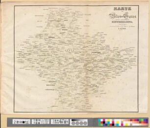
General-Karte der Pfalz nach der Territorial-Eintheilung vor der französischen Revolution
- Location
-
München, Bayerische Staatsbibliothek -- Hbks/F 19 ap#Kt.14
- Dimensions
-
41 x 39 cm, Bildgr. 52 x 40 cm
- Extent
-
1 Kt.
- Language
-
Deutsch
- Notes
-
mehrfarb.
Inselkt. - Titel links unten. - Mit Bergstrichen. - Ohne Kt.-Netz
- Bibliographic citation
-
Die Pfalz ; 14
- Keyword
-
Geschichte
Verwaltungsgrenze
Pfalz
- Event
-
Veröffentlichung
- (where)
-
Zweibrücken
- (who)
-
G. Ritter
- (when)
-
[1840]
- Contributor
-
Ritter, Georg
- URN
-
urn:nbn:de:bvb:12-bsb00090698-5
- Last update
-
16.04.2025, 8:47 AM CEST
Data provider
This object is provided by:
Bayerische Staatsbibliothek. If you have any questions about the object, please contact the data provider.
Bayerische Staatsbibliothek. If you have any questions about the object, please contact the data provider.
Object type
- Altkarte
Associated
- Ritter, Georg
- G. Ritter
Time of origin
- [1840]
Other Objects (12)
Karte des Blies-Gaues nach der vorrevolutionären Eintheilung

Die Pfalz : Special-Karten der zwölf Land-Commissariats-Bezirken, im Massstabe von 1/111600 der natürlichen Länge, nebst der Generalkarte der Pfalz und des Bliesgaus nach der Territorial-Eintheilung vor der französischen Revolution, 0

Die Pfalz : Special-Karten der zwölf Land-Commissariats-Bezirken, im Massstabe von 1/111600 der natürlichen Länge, nebst der Generalkarte der Pfalz und des Bliesgaus nach der Territorial-Eintheilung vor der französischen Revolution, 10. Special-Karte des Land-Commissariats-Bezirks Pirmasens

Die Pfalz : Special-Karten der zwölf Land-Commissariats-Bezirken, im Massstabe von 1/111600 der natürlichen Länge, nebst der Generalkarte der Pfalz und des Bliesgaus nach der Territorial-Eintheilung vor der französischen Revolution, 7. Special-Karte des Land-Commissariats-Bezirks Kusel

Die Pfalz : Special-Karten der zwölf Land-Commissariats-Bezirken, im Massstabe von 1/111600 der natürlichen Länge, nebst der Generalkarte der Pfalz und des Bliesgaus nach der Territorial-Eintheilung vor der französischen Revolution, 5. Special-Karte des Land-Commissariats-Bezirks Kaiserslautern

Die Pfalz : Special-Karten der zwölf Land-Commissariats-Bezirken, im Massstabe von 1/111600 der natürlichen Länge, nebst der Generalkarte der Pfalz und des Bliesgaus nach der Territorial-Eintheilung vor der französischen Revolution, 11. Special-Karte des Land-Commissariats-Bezirks Speyer

Die Pfalz : Special-Karten der zwölf Land-Commissariats-Bezirken, im Massstabe von 1/111600 der natürlichen Länge, nebst der Generalkarte der Pfalz und des Bliesgaus nach der Territorial-Eintheilung vor der französischen Revolution, 1. Special-Karte des Land-Commissariats-Bezirks Bergzabern

Die Pfalz : Special-Karten der zwölf Land-Commissariats-Bezirken, im Massstabe von 1/111600 der natürlichen Länge, nebst der Generalkarte der Pfalz und des Bliesgaus nach der Territorial-Eintheilung vor der französischen Revolution, 2. Special-Karte des Land-Commissariats-Bezirks Frankenthal

Die Pfalz : Special-Karten der zwölf Land-Commissariats-Bezirken, im Massstabe von 1/111600 der natürlichen Länge, nebst der Generalkarte der Pfalz und des Bliesgaus nach der Territorial-Eintheilung vor der französischen Revolution, 12. Special-Karte des Land-Commissariats-Bezirks Zweibrücken

Die Pfalz : Special-Karten der zwölf Land-Commissariats-Bezirken, im Massstabe von 1/111600 der natürlichen Länge, nebst der Generalkarte der Pfalz und des Bliesgaus nach der Territorial-Eintheilung vor der französischen Revolution, 3. Special-Karte des Land-Commissariats-Bezirks Germersheim

Die Pfalz : Special-Karten der zwölf Land-Commissariats-Bezirken, im Massstabe von 1/111600 der natürlichen Länge, nebst der Generalkarte der Pfalz und des Bliesgaus nach der Territorial-Eintheilung vor der französischen Revolution, 9. Special-Karte des Land-Commissariats-Bezirks Neustadt

Die Pfalz : Special-Karten der zwölf Land-Commissariats-Bezirken, im Massstabe von 1/111600 der natürlichen Länge, nebst der Generalkarte der Pfalz und des Bliesgaus nach der Territorial-Eintheilung vor der französischen Revolution, 4. Special-Karte des Land-Commissariats-Bezirks Homburg
Karte des Blies-Gaues nach der vorrevolutionären Eintheilung
Die Pfalz : Special-Karten der zwölf Land-Commissariats-Bezirken, im Massstabe von 1/111600 der natürlichen Länge, nebst der Generalkarte der Pfalz und des Bliesgaus nach der Territorial-Eintheilung vor der französischen Revolution, 0
Die Pfalz : Special-Karten der zwölf Land-Commissariats-Bezirken, im Massstabe von 1/111600 der natürlichen Länge, nebst der Generalkarte der Pfalz und des Bliesgaus nach der Territorial-Eintheilung vor der französischen Revolution, 10. Special-Karte des Land-Commissariats-Bezirks Pirmasens
Die Pfalz : Special-Karten der zwölf Land-Commissariats-Bezirken, im Massstabe von 1/111600 der natürlichen Länge, nebst der Generalkarte der Pfalz und des Bliesgaus nach der Territorial-Eintheilung vor der französischen Revolution, 7. Special-Karte des Land-Commissariats-Bezirks Kusel
Die Pfalz : Special-Karten der zwölf Land-Commissariats-Bezirken, im Massstabe von 1/111600 der natürlichen Länge, nebst der Generalkarte der Pfalz und des Bliesgaus nach der Territorial-Eintheilung vor der französischen Revolution, 5. Special-Karte des Land-Commissariats-Bezirks Kaiserslautern
Die Pfalz : Special-Karten der zwölf Land-Commissariats-Bezirken, im Massstabe von 1/111600 der natürlichen Länge, nebst der Generalkarte der Pfalz und des Bliesgaus nach der Territorial-Eintheilung vor der französischen Revolution, 11. Special-Karte des Land-Commissariats-Bezirks Speyer
Die Pfalz : Special-Karten der zwölf Land-Commissariats-Bezirken, im Massstabe von 1/111600 der natürlichen Länge, nebst der Generalkarte der Pfalz und des Bliesgaus nach der Territorial-Eintheilung vor der französischen Revolution, 1. Special-Karte des Land-Commissariats-Bezirks Bergzabern
Die Pfalz : Special-Karten der zwölf Land-Commissariats-Bezirken, im Massstabe von 1/111600 der natürlichen Länge, nebst der Generalkarte der Pfalz und des Bliesgaus nach der Territorial-Eintheilung vor der französischen Revolution, 2. Special-Karte des Land-Commissariats-Bezirks Frankenthal
Die Pfalz : Special-Karten der zwölf Land-Commissariats-Bezirken, im Massstabe von 1/111600 der natürlichen Länge, nebst der Generalkarte der Pfalz und des Bliesgaus nach der Territorial-Eintheilung vor der französischen Revolution, 12. Special-Karte des Land-Commissariats-Bezirks Zweibrücken
Die Pfalz : Special-Karten der zwölf Land-Commissariats-Bezirken, im Massstabe von 1/111600 der natürlichen Länge, nebst der Generalkarte der Pfalz und des Bliesgaus nach der Territorial-Eintheilung vor der französischen Revolution, 3. Special-Karte des Land-Commissariats-Bezirks Germersheim
Die Pfalz : Special-Karten der zwölf Land-Commissariats-Bezirken, im Massstabe von 1/111600 der natürlichen Länge, nebst der Generalkarte der Pfalz und des Bliesgaus nach der Territorial-Eintheilung vor der französischen Revolution, 9. Special-Karte des Land-Commissariats-Bezirks Neustadt