Seekarte
The Sea of Marmara or Propontis with the Straits of Constantinople and of Gallipoli. Mit einer Nebenkarte: A map of the coasts of Grece and Archipelago
- Alternativer Titel
-
THE SEA OF MARMARA OR PROPONTIS, / WITH THE STRAITS OF CONSTANTINOPLE AND OF GALLIPOLI / By WM. FADEN Geographer to the King
- Standort
-
Deutsches Historisches Museum, Berlin
- Inventarnummer
-
Do 2006/1033.1-2
- Maße
-
Höhe x Breite: 76,6 x 57,5 cm (Blatt 1)
Höhe x Breite: 58,7 x 49 cm (Karte 1)
Höhe x Breite: 61 x 51 cm (Platte 1)
Höhe x Breite: 77 x 57,5 cm (Blatt 2)
Höhe x Breite: 58,7 x 54,3 cm (Karte 2)
- Material/Technik
-
Papier, Kupferstich, teilkoloriert
- Klassifikation
-
Kartografie (Gattung)
- Bezug (was)
-
Marmarameer
Türkei
- Ereignis
-
Herstellung
- (wer)
-
Verleger, Kartograf, Stecher: William Faden
Stecher, Kartograf: William Palmer
Geograph, Kartograf: Jean Baptiste Bourguignon d' Anville
- (wo)
-
London, Großbritannien und Nordirland
- (wann)
-
1786
- Rechteinformation
-
Deutsches Historisches Museum
- Letzte Aktualisierung
-
24.03.2023, 09:27 MEZ
Datenpartner
Dieses Objekt wird bereitgestellt von:
Stiftung Deutsches Historisches Museum. Bei Fragen zum Objekt wenden Sie sich bitte an den Datenpartner.
Stiftung Deutsches Historisches Museum. Bei Fragen zum Objekt wenden Sie sich bitte an den Datenpartner.
Objekttyp
- Seekarte
Beteiligte
- Verleger, Kartograf, Stecher: William Faden
- Stecher, Kartograf: William Palmer
- Geograph, Kartograf: Jean Baptiste Bourguignon d' Anville
Entstanden
- 1786
Ähnliche Objekte (12)

Songs of the Constantinople and the Sea of Marmara
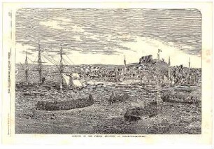
Landing of the French Infantry at Gallipoli

3-D crustal density model of the Sea of Marmara
3-D crustal density model of the Sea of Marmara
Piracy off the coasts of Somalia
On the Laws of the Tides on the Coasts of Ireland
The earthquake sedimentary record in the western part of the Sea of Marmara, Turkey
Environmental changes on the coasts of Indonesia
The Manners and Customs of the Indians near the Coasts.
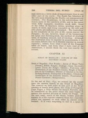
Chapter XI - Strait of Magellan; Climate of the Southern Coasts
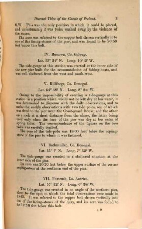
On the solar and lunar diurnal tides of the coasts of Ireland
Dunes of the European coasts : geomorphology - hydrology - soils
Songs of the Constantinople and the Sea of Marmara
Landing of the French Infantry at Gallipoli
3-D crustal density model of the Sea of Marmara
3-D crustal density model of the Sea of Marmara
Piracy off the coasts of Somalia
On the Laws of the Tides on the Coasts of Ireland
The earthquake sedimentary record in the western part of the Sea of Marmara, Turkey
Environmental changes on the coasts of Indonesia
The Manners and Customs of the Indians near the Coasts.
Chapter XI - Strait of Magellan; Climate of the Southern Coasts
On the solar and lunar diurnal tides of the coasts of Ireland