Luftbildpläne
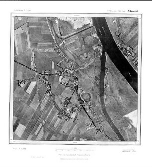
Altenesch, Gauß-Krüger-Koordinaten: Rechtswert: 3474, Hochwert: 5888
- Reference number
-
RW 0230, 772
- Dimensions
-
Höhe: 60, Breite: 60, Maßstab: 1:5.000
- Notes
-
Nicht in der Bildmittenkarte verzeichnet
- Context
-
Hansa Luftbild AG, Luftbildpläne 1951-1970 >> 5. Rechswerte beginnend mit 34 >> 5.40. 3474
- Holding
-
RW 0230 Hansa Luftbild AG, Luftbildpläne 1951-1970
- Provenance
-
Hansa Luftbild
- Date of creation
-
1.10.1951, 9.10.1951
- Other object pages
- Delivered via
- Zugangsbeschränkungen
-
Digitalisat vorhanden: Original für die Nutzung gesperrt. Digitalisat vorhanden
- Last update
-
24.06.2025, 1:55 PM CEST
Data provider
This object is provided by:
Landesarchiv Nordrhein-Westfalen. Abteilung Rheinland. If you have any questions about the object, please contact the data provider.
Landesarchiv Nordrhein-Westfalen. Abteilung Rheinland. If you have any questions about the object, please contact the data provider.
Object type
- Luftbildpläne
Associated
- Hansa Luftbild
Time of origin
- 1.10.1951, 9.10.1951
Other Objects (12)
Altenesch, Gauß-Krüger-Koordinaten: Rechtswert: 3474, Hochwert: 5888

Holttange, Gauß-Krüger-Koordinaten: Rechtswert: 3428, Hochwert: 5888
Strücklingen, Gauß-Krüger-Koordinaten: Rechtswert: 3410, Hochwert: 5888
Nesseburg, Gauß-Krüger-Koordinaten: Rechtswert: 2590, Hochwert: 5888
Flachsmeer, Gauß-Krüger-Koordinaten: Rechtswert: 2596, Hochwert: 5888

Diele, Gauß-Krüger-Koordinaten: Rechtswert: 2588, Hochwert: 5888
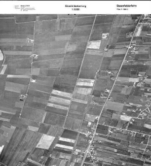
Steenfelderfehn, Gauß-Krüger-Koordinaten: Rechtswert: 2594, Hochwert: 5888
Mitling, Gauß-Krüger-Koordinaten: Rechtswert: 2592, Hochwert: 5888

Grosswolderfeld, Gauß-Krüger-Koordinaten: Rechtswert: 2598, Hochwert: 5888

Westerscheps, Gauß-Krüger-Koordinaten: Rechtswert: 3426, Hochwert: 5888

Strücklingen, Gauß-Krüger-Koordinaten: Rechtswert: 3410, Hochwert: 5888
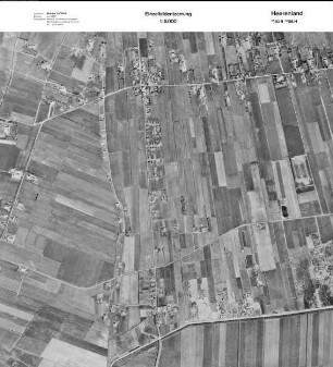
Heerenland, Gauß-Krüger-Koordinaten: Rechtswert: 2580, Hochwert: 5888
Altenesch, Gauß-Krüger-Koordinaten: Rechtswert: 3474, Hochwert: 5888
Holttange, Gauß-Krüger-Koordinaten: Rechtswert: 3428, Hochwert: 5888
Strücklingen, Gauß-Krüger-Koordinaten: Rechtswert: 3410, Hochwert: 5888
Nesseburg, Gauß-Krüger-Koordinaten: Rechtswert: 2590, Hochwert: 5888
Flachsmeer, Gauß-Krüger-Koordinaten: Rechtswert: 2596, Hochwert: 5888
Diele, Gauß-Krüger-Koordinaten: Rechtswert: 2588, Hochwert: 5888
Steenfelderfehn, Gauß-Krüger-Koordinaten: Rechtswert: 2594, Hochwert: 5888
Mitling, Gauß-Krüger-Koordinaten: Rechtswert: 2592, Hochwert: 5888
Grosswolderfeld, Gauß-Krüger-Koordinaten: Rechtswert: 2598, Hochwert: 5888
Westerscheps, Gauß-Krüger-Koordinaten: Rechtswert: 3426, Hochwert: 5888
Strücklingen, Gauß-Krüger-Koordinaten: Rechtswert: 3410, Hochwert: 5888