- Alternative title
-
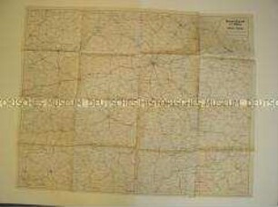
Rußland-Nord
- Location
-
Deutsches Historisches Museum, Berlin
- Inventory number
-
Do2 94/3482
- Measurements
-
Höhe x Breite: 138 x 108 cm
- Material/Technique
-
Papier, gedruckt
- Classification
-
Kartografie (Gattung)
- Subject (what)
-
Geographie
- Event
-
Herstellung
- (who)
-
Herausgeber: Lithografisches Institut
- (where)
-
Berlin, Deutschland [historisch: Deutsches Reich]
- (when)
-
um 1942
- Rights
-
Deutsches Historisches Museum
- Last update
-
24.03.2023, 9:30 AM CET
Data provider
This object is provided by:
Stiftung Deutsches Historisches Museum. If you have any questions about the object, please contact the data provider.
Stiftung Deutsches Historisches Museum. If you have any questions about the object, please contact the data provider.
Object type
- Geographische Karte
Associated
- Herausgeber: Lithografisches Institut
Time of origin
- um 1942
Other Objects (12)
Geographische Karte des zentralen Teils der RSFSR

Zivilgesetzbuch der RSFSR
Zivilgesetzbuch der RSFSR
UdSSR.- RSFSR
UdSSR.- RSFSR
UdSSR.- RSFSR
Die Zivilprozessordnung der RSFSR
Lehrerbildung in der RSFSR

Sowjetunion (R.S.F.S.R) , 50 Kopeken
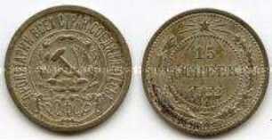
Sowjetunion (R.S.F.S.R) , 15 Kopeken

Sowjetunion (R.S.F.S.R) , 10 Kopeken
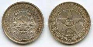
Sowjetunion (R.S.F.S.R) , 50 Kopeken
Geographische Karte des zentralen Teils der RSFSR
Zivilgesetzbuch der RSFSR
Zivilgesetzbuch der RSFSR
UdSSR.- RSFSR
UdSSR.- RSFSR
UdSSR.- RSFSR
Die Zivilprozessordnung der RSFSR
Lehrerbildung in der RSFSR
Sowjetunion (R.S.F.S.R) , 50 Kopeken
Sowjetunion (R.S.F.S.R) , 15 Kopeken
Sowjetunion (R.S.F.S.R) , 10 Kopeken
Sowjetunion (R.S.F.S.R) , 50 Kopeken
Geographische Karte des zentralen Teils der RSFSR
Zivilgesetzbuch der RSFSR
Zivilgesetzbuch der RSFSR
UdSSR.- RSFSR
UdSSR.- RSFSR
UdSSR.- RSFSR
Die Zivilprozessordnung der RSFSR
Lehrerbildung in der RSFSR
Sowjetunion (R.S.F.S.R) , 50 Kopeken
Sowjetunion (R.S.F.S.R) , 15 Kopeken
Sowjetunion (R.S.F.S.R) , 10 Kopeken