Regionalkarte
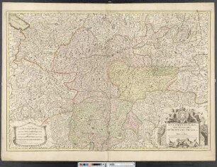
Grand Atlas . Bl. 78 (Tirol, Kärnten, Brixen): Contenant une Partie du Comte de Tirol et du Duche de Carinthie Superieure et l'Eveche de Brixen
- Alternative title
-
CARTE TOPOGRAPHIQUE D'ALLEMAGNE / Contenant une Partie du COMTE de TIROL et du DUCHE de CARINTHIE SUPERIEURE et l'EVECHE de BRIXEN
- Location
-
Deutsches Historisches Museum, Berlin
- Inventory number
-
Do 2006/1059.78
- Measurements
-
Höhe x Breite: 56,5 x 78 cm, Höhe: 56,5 cm, Breite: 78 cm, Tiefe: 3 cm (Atlas)
Höhe x Breite: 56,5 x 78 cm (Blatt)
Höhe x Breite: 52 x 68 cm (Platte)
Höhe x Breite: 46 x 59 cm (Karte)
- Material/Technique
-
Papier, Kupferstich, koloriert, gebunden |Fadenheftung
- Classification
-
Kartografie (Gattung)
- Subject (what)
-
Deutschland
- Event
-
Herstellung
- (who)
-
Verleger, Militärkartograph: Johann Wilhelm Abraham Jaeger
Stecher: Johann Christian Berndt
- (where)
-
Frankfurt (Main) [historisch: Frankfurt, Reichsstadt], Deutschland
- (when)
-
um 1789
- Rights
-
Deutsches Historisches Museum
- Last update
-
24.03.2023, 9:29 AM CET
Data provider
This object is provided by:
Stiftung Deutsches Historisches Museum. If you have any questions about the object, please contact the data provider.
Stiftung Deutsches Historisches Museum. If you have any questions about the object, please contact the data provider.
Object type
- Regionalkarte
Associated
- Verleger, Militärkartograph: Johann Wilhelm Abraham Jaeger
- Stecher: Johann Christian Berndt
Time of origin
- um 1789
Other Objects (12)

Bl. XLIX: Le Comté du Tirol l'Eveché de Trente et de Brixen avec les Routtes et Passages.
Tirol und die Adlerwappen seiner Länder : Tirol - Südtirol - Brixen - Trient
Heyl, Adolph: Auswanderung nach Österreich (Tirol, Brixen)
Le Comté De Tirol, Les Eveschés De Trente et De Brixen, &c.
Die Passivlehen des Hochstifts Brixen in Tirol und Bayern
Die Passivlehen des Hochstifts Brixen in Tirol und Bayern
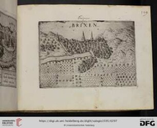
6: Romanische Wandmalereien in Tirol, 3, Aus der Johannescapelle zu Brixen
Prozeß zwischen Tirol und den Bistümern Brixen und Trient wegen Unterhaltsverpflichtungen
Österreich, Brixen / Kinderdorf Brixen, Ansicht
Brixen
Brixen
Brixen
Bl. XLIX: Le Comté du Tirol l'Eveché de Trente et de Brixen avec les Routtes et Passages.
Tirol und die Adlerwappen seiner Länder : Tirol - Südtirol - Brixen - Trient
Heyl, Adolph: Auswanderung nach Österreich (Tirol, Brixen)
Le Comté De Tirol, Les Eveschés De Trente et De Brixen, &c.
Die Passivlehen des Hochstifts Brixen in Tirol und Bayern
Die Passivlehen des Hochstifts Brixen in Tirol und Bayern
6: Romanische Wandmalereien in Tirol, 3, Aus der Johannescapelle zu Brixen
Prozeß zwischen Tirol und den Bistümern Brixen und Trient wegen Unterhaltsverpflichtungen
Österreich, Brixen / Kinderdorf Brixen, Ansicht
Brixen
Brixen