Karten und Pläne
Universal-Länder- und Ortsverzeichnis
Ausführlicher Titel: Orbis in tabula, d[as] i[ist] Geographische Universalkarte, 1. Theil vorstellend auf einem einzigen Blatt ausgenommen Teutschland alle Theile, Reiche, Staaten und vornehmste Örter der gantzen Welt .../ Orbis in tabula s[ive] universae geographiae representatio synoptica ...
Enthält:
Weltteile, Reiche, Orte in Listen-Kolumnen; Legende; Farben verblasst
- Reference number
-
Abt. Generallandesarchiv Karlsruhe, 98-1 Nr. 1357
- Dimensions
-
53 x 61 (Blatt), 50 x 57 (Platte), 48 x 56 (Texttafel), 66 (Stäbe) (Höhe x Breite)
- Notes
-
Kupferstich; Papier auf Leinwand, oben und unten auf gedrechselte Holzleisten geklebt
- Further information
-
Herausgeber: Homanns Erben
Herstellungsort: Nürnberg
- Context
-
Kloster Salem: Nachträge aus Schloss Salem >> Pläne >> Gedruckte Landkarten >> Allgemein
- Holding
-
Landesarchiv Baden-Württemberg, Abt. Generallandesarchiv Karlsruhe, 98-1 Kloster Salem: Nachträge aus Schloss Salem
- Indexentry person
-
Gross, Johann Gottfried
- Creator
-
Autor/Fotograf: Gross, Johann Gottfried
- Other object pages
- Rights
-
Es gelten die Nutzungsbedingungen des Landesarchivs Baden-Württemberg.
- Last update
-
04.04.2025, 8:11 AM CEST
Data provider
This object is provided by:
Landesarchiv Baden-Württemberg. If you have any questions about the object, please contact the data provider.
Landesarchiv Baden-Württemberg. If you have any questions about the object, please contact the data provider.
Object type
- Karten und Pläne
Associated
- Autor/Fotograf: Gross, Johann Gottfried
Other Objects (12)

Deutsches Kreis-, Länder- und Ortsverzeichnis
Vervoort-Universal-Wander- Rost
Aufstellung einer Universal-Schrot- und Mahlmühle (Hauptgut)

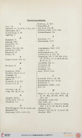
Ortsverzeichnis
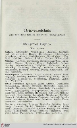
Ortsverzeichnis

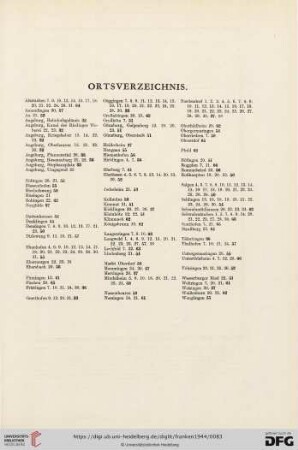
Ortsverzeichnis

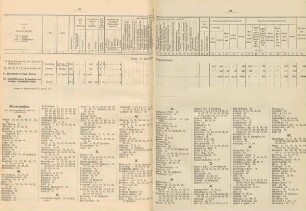
Ortsverzeichnis
Ortsverzeichnis
Ortsverzeichnis

Ortsverzeichnis
Ortsverzeichnis

Ortsverzeichnis
Deutsches Kreis-, Länder- und Ortsverzeichnis
Vervoort-Universal-Wander- Rost
Aufstellung einer Universal-Schrot- und Mahlmühle (Hauptgut)
Ortsverzeichnis
Ortsverzeichnis
Ortsverzeichnis
Ortsverzeichnis
Ortsverzeichnis
Ortsverzeichnis
Ortsverzeichnis
Ortsverzeichnis
Ortsverzeichnis
Deutsches Kreis-, Länder- und Ortsverzeichnis
Vervoort-Universal-Wander- Rost
Aufstellung einer Universal-Schrot- und Mahlmühle (Hauptgut)
Ortsverzeichnis
Ortsverzeichnis
Ortsverzeichnis
Ortsverzeichnis
Ortsverzeichnis
Ortsverzeichnis
Ortsverzeichnis
Ortsverzeichnis