Geografische Karten
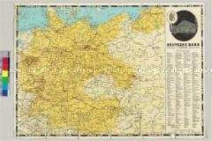
Landkarte von Mitteleuropa mit Deutschland in den Grenzen nach dem Münchener Abkommen
- Alternative title
-
Karte von Groß-Deutschland
- Location
-
Deutsches Historisches Museum, Berlin
- Inventory number
-
Do 63/250
- Measurements
-
Höhe x Breite: 21 x 10 cm (gefaltet), Höhe x Breite: 42 x 60 cm (aufgeschlagen)
- Material/Technique
-
Papier, gedruckt
- Classification
-
Kartografie (Gattung)
- Subject (what)
-
Geographie
Straßenverkehr
- Event
-
Herstellung
- (who)
-
Herausgeber: Deutsche Bank
- (where)
-
Berlin, Deutschland [historisch: Deutsches Reich]
- (when)
-
1938
- Rights
-
Deutsches Historisches Museum
- Last update
-
24.03.2023, 9:27 AM CET
Data provider
This object is provided by:
Stiftung Deutsches Historisches Museum. If you have any questions about the object, please contact the data provider.
Stiftung Deutsches Historisches Museum. If you have any questions about the object, please contact the data provider.
Object type
- Geografische Karten
Associated
- Herausgeber: Deutsche Bank
Time of origin
- 1938
Other Objects (12)

Landkarte von Mitteleuropa mit Deutschland in den Grenzen nach dem Münchener Abkommen
Landkarte von Mitteleuropa mit Deutschland in den Grenzen nach dem Münchener Abkommen
Grafische Darstellung des Börsenkurses für Baumwolle
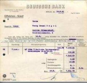
Quittung der Deutschen Bank über den Verkauf von Wertpapieren (7.340,79 RM) an einen Juden und deren Deponierung in der Bank
Grafische Darstellung des Börsenkurses für Petroleum

2-DM-Stück (unbrauchbar gemacht, Euroumstellung)
Berechtigungsausweis zum Betreten des Tresorraumes der Deutschen Bank - Personenkonvolut
Deutsche Bank, Berlin W 8, gegr. 1870 : [Unsere Wohlfahrtseinrichtungen]

200 Mark - Abbildung

Werbekarte für die Deutsche Bank Card mit Wunschmotiv
Beutel mit geschredderten DM-Banknoten
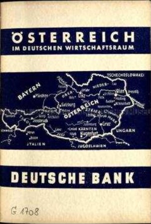
Volkswirtschaftliche Schrift über die Wirtschaftsstruktur Österreichs
Landkarte von Mitteleuropa mit Deutschland in den Grenzen nach dem Münchener Abkommen
Landkarte von Mitteleuropa mit Deutschland in den Grenzen nach dem Münchener Abkommen
Grafische Darstellung des Börsenkurses für Baumwolle
Quittung der Deutschen Bank über den Verkauf von Wertpapieren (7.340,79 RM) an einen Juden und deren Deponierung in der Bank
Grafische Darstellung des Börsenkurses für Petroleum
2-DM-Stück (unbrauchbar gemacht, Euroumstellung)
Berechtigungsausweis zum Betreten des Tresorraumes der Deutschen Bank - Personenkonvolut
Deutsche Bank, Berlin W 8, gegr. 1870 : [Unsere Wohlfahrtseinrichtungen]
200 Mark - Abbildung
Werbekarte für die Deutsche Bank Card mit Wunschmotiv
Beutel mit geschredderten DM-Banknoten