Karten / Pläne
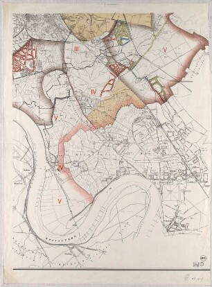
Wattenscheid (Bochum) Ortsplan (Teilkarte) vor 1950 78,5 x 112 Druck B Nr. 1287
- Former reference number
-
B 1287
- Further information
-
Ort: Wattenscheid, Bochum
- Context
-
Karten A (Allgemein) >> 1. Topographische Karte, Übersichtskarten >> 1.5. Stadt-/ Ortspläne
- Holding
-
W 051 Karten A (Allgemein)
- Indexentry place
-
Wattenscheid, Bochum
Wattenscheid, Ortsplan, 1950
- Provenance
-
Sammlungsregistraturbildner
- Date of creation
-
1950
- Other object pages
- Delivered via
- Last update
-
24.06.2025, 1:19 PM CEST
Data provider
This object is provided by:
Landesarchiv Nordrhein-Westfalen. Abteilung Westfalen. If you have any questions about the object, please contact the data provider.
Landesarchiv Nordrhein-Westfalen. Abteilung Westfalen. If you have any questions about the object, please contact the data provider.
Object type
- Karten / Pläne
Associated
- Sammlungsregistraturbildner
Time of origin
- 1950
Other Objects (12)

Campow Teilkarte
Klütz - Teilkarte
Klütz - Teilkarte
Klütz - Teilkarte
Teilkarte der Oberförsterei Spandau
Topographische Teilkarte von Düsseldorf
Teilkarte der Flur VIII
[Teilkarte der Provinz Brandenburg]
Topographische Teilkarte von Düsseldorf
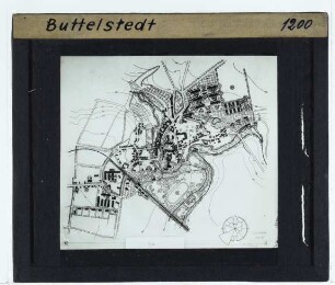
Stadtplan/Ortsplan : Ortsplan Butteklstedt
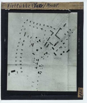
Stadtplan/Ortsplan : Ortsplan Vietlübbe
Deschka. 1 Teilkarte Abteilung a
Campow Teilkarte
Klütz - Teilkarte
Klütz - Teilkarte
Klütz - Teilkarte
Teilkarte der Oberförsterei Spandau
Topographische Teilkarte von Düsseldorf
Teilkarte der Flur VIII
[Teilkarte der Provinz Brandenburg]
Topographische Teilkarte von Düsseldorf
Stadtplan/Ortsplan : Ortsplan Butteklstedt
Stadtplan/Ortsplan : Ortsplan Vietlübbe