Altkarte
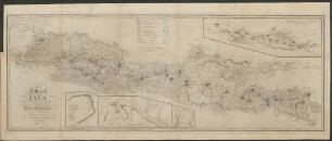
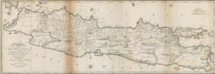
A Map of Java : Chiefly from Surveys made during the British Administration
- Standort
-
München, Bayerische Staatsbibliothek -- BA/4 H.as. 671-2#Kartenblatt 3
- Maße
-
110 x 39 cm, gefaltet
- Umfang
-
1 Kt.
- Sprache
-
Englisch
- Anmerkungen
-
Lithographie
Nullmeridian Greenwich. - Mit 1 Nebenkt. u. 4 Hafenplänen: Mineralogical Sketch Of The Island Of Java. Plan of Palabuan Ratu or Wyn Coops Bay. Harbours Formed by the Island Nusa Kambang'an. Bay Of Pachitan. - Maßstab in graph. Form (British Statute Miles ; Dutch Miles). - Mit 1 Tab. - Mit Tiefenangaben. - Mit Bergstrichen
- Erschienen in
-
Déscription géographique historique et commerciale de Java et des autres îles De l'archipel indien ; [2]. [Atlas] ; [Karte 3]
- Schlagwort
-
Java
- Ereignis
-
Veröffentlichung
- (wo)
-
London [erschienen: Bruxelles]
- (wer)
-
Black Parbury & Allen [erschienen: Tarlier]
- (wann)
-
1817 [erschienen 1824]
- Beteiligte Personen und Organisationen
- URN
-
urn:nbn:de:bvb:12-bsb00042860-7
- Letzte Aktualisierung
- 27.11.2025, 08:46 MEZ
Datenpartner
Dieses Objekt wird bereitgestellt von:
Bayerische Staatsbibliothek. Bei Fragen zum Objekt wenden Sie sich bitte an den Datenpartner.
Bayerische Staatsbibliothek. Bei Fragen zum Objekt wenden Sie sich bitte an den Datenpartner.
Objekttyp
- Altkarte
Beteiligte
- Raffles, Thomas Stamford (Sonstige)
- Walker, John (Sonstige)
- Black Parbury & Allen [erschienen: Tarlier]
Entstanden
- 1817 [erschienen 1824]
Ähnliche Objekte (12)
A Map of Java
Map of the Island of Java

JOSM – Java OpenStreetMap Editor

Scribe: MapServer Mapfile Development Made Easy

MapStore 2, modern mashups made simple

JOSM - Der Java OpenStreetMap Editor
A Correct Map of Cumberland from the best Surveys

ScribeUI: MapServer Mapfile management made easy

Lectures : Chiefly clinical
An Accurate Map of Essex : Drawn from late Surveys with Improvements

Map of public surveys in California : to accompany report of Surveyor Genl.

Old English glosses : chiefly unpublished
A Map of Java
Map of the Island of Java
JOSM – Java OpenStreetMap Editor
Scribe: MapServer Mapfile Development Made Easy
MapStore 2, modern mashups made simple
JOSM - Der Java OpenStreetMap Editor
A Correct Map of Cumberland from the best Surveys
ScribeUI: MapServer Mapfile management made easy
Lectures : Chiefly clinical
An Accurate Map of Essex : Drawn from late Surveys with Improvements
Map of public surveys in California : to accompany report of Surveyor Genl.