- Alternative title
-
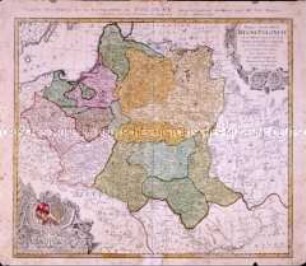
Carte des Etats de la COVRONNE de POLOGNE, nouvellement dessinee par M.r Tob. Mayer/ et publiée par les Heritiers de Homann l'an MDCCLVII./ Mappa Geographica/ REGNI POLONIAE/ ex novissimis quotquot sunt/ mappis specialibus composita/ et ad LL. stereographica/ projectionis revocata à/ Tob. Mayero. S.C.S./ Luci publicae tradita per/ Homannianos Heredes./ Norimb. A. MDCCLVII.
- Location
-
Deutsches Historisches Museum, Berlin
- Inventory number
-
Do 2002/153
- Measurements
-
Höhe x Breite: 52,1 x 61,4 cm (Blatt), Höhe x Breite: 49,5 x 58,3 cm (Platte)
- Material/Technique
-
Papier, Kupferstich, koloriert
- Classification
-
Kartografie (Gattung)
- Subject (what)
-
Polen
- Event
-
Herstellung
- (who)
-
Kartograf: Johann Tobias Mayer
Verlag: Homannsche Erben
- (where)
-
Nürnberg [historisch: Norimbergae], Deutschland [historisch: Heiliges Römisches Reich]
- (when)
-
1757
- Rights
-
Deutsches Historisches Museum
- Last update
-
24.03.2023, 9:30 AM CET
Data provider
This object is provided by:
Stiftung Deutsches Historisches Museum. If you have any questions about the object, please contact the data provider.
Stiftung Deutsches Historisches Museum. If you have any questions about the object, please contact the data provider.
Object type
- Regionalkarte
Associated
- Kartograf: Johann Tobias Mayer
- Verlag: Homannsche Erben
Time of origin
- 1757
Other Objects (12)
Mappa Geographica Regni Poloniae
Mappa geographica exhibens Principatum Brandenburgico Onolsbacensem
Regni Sinae vel Sinae Propriae Mappa et Descriptio Geographica

Repraesentatio Geographica Circuli Egerani
Tatariae Sinensis Mappa Geographica / Carte Generale de la Tatarie Chinoise
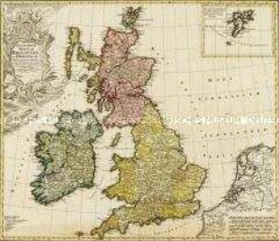
Regnorum Magnae Britanniae Et Hiberniae Mappa Geographica. Mit einer Nebenkarte: Insulae Schetlandiae
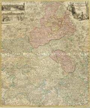
Tabula Geographica Campaniae. Mit zwei Nebenkarten: Reims und Troyes

Tabula Geographica Totam Borussiam ut et Districtum Notecensem. Mit einer Nebenkarte: Charte welche den Netz District vorstellet
Delineatio Geographica [...] Vogtlandiae
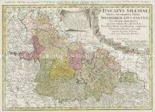
Ducatus Silesiae Tabula Geographica Prima Inferiorem eius Partem seu Nova Principatus
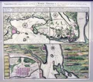
Pläne der kanadischen Städte Louisburg, Québec und Halifax unter französischer und englischer Herrschaft
La Comtè de Glatz
Mappa Geographica Regni Poloniae
Mappa geographica exhibens Principatum Brandenburgico Onolsbacensem
Regni Sinae vel Sinae Propriae Mappa et Descriptio Geographica
Repraesentatio Geographica Circuli Egerani
Tatariae Sinensis Mappa Geographica / Carte Generale de la Tatarie Chinoise
Regnorum Magnae Britanniae Et Hiberniae Mappa Geographica. Mit einer Nebenkarte: Insulae Schetlandiae
Tabula Geographica Campaniae. Mit zwei Nebenkarten: Reims und Troyes
Tabula Geographica Totam Borussiam ut et Districtum Notecensem. Mit einer Nebenkarte: Charte welche den Netz District vorstellet
Delineatio Geographica [...] Vogtlandiae
Ducatus Silesiae Tabula Geographica Prima Inferiorem eius Partem seu Nova Principatus
Pläne der kanadischen Städte Louisburg, Québec und Halifax unter französischer und englischer Herrschaft