- Reference number
-
Slg. 17, II/1 (Benutzungsort: Dessau)
- Former reference number
-
Akz. 16/97
- Dimensions
-
Höhe (cm): 23.8; Breite (cm): 34.7
- Context
-
Karten Anhalts >> I. Karten des Fürsten- bzw. Herzogtums Anhalt und angrenzender kursächsischer Gebiete
- Holding
-
Slg. 17 (Benutzungsort: Dessau) Karten Anhalts
- Date of creation
-
[1581 - 1942, nach 2000, 2012]
- Other object pages
- Last update
-
17.04.2025, 3:24 PM CEST
Data provider
This object is provided by:
Landesarchiv Sachsen-Anhalt. If you have any questions about the object, please contact the data provider.
Landesarchiv Sachsen-Anhalt. If you have any questions about the object, please contact the data provider.
Object type
- Karten und Pläne
Time of origin
- [1581 - 1942, nach 2000, 2012]
Other Objects (12)
![Karte des Konsisturiums Wittenberg, ca. 1:510 000, Kupferstich, 1759 : Le Consistoire et Environs De Wittenberg dans la Haute-Saxe. - [Ca. 1:510 000]. - [Paris] : [LeRouge] , [1759]. - 1 Kt. : Kupferst. ; 27 x 20 cm](https://iiif.deutsche-digitale-bibliothek.de/image/2/d1d429e6-1291-4c97-aa1b-0a7377ad2e25/full/!306,450/0/default.jpg)
Karte des Konsisturiums Wittenberg, ca. 1:510 000, Kupferstich, 1759 : Le Consistoire et Environs De Wittenberg dans la Haute-Saxe. - [Ca. 1:510 000]. - [Paris] : [LeRouge] , [1759]. - 1 Kt. : Kupferst. ; 27 x 20 cm

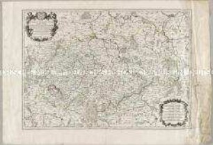
Wittenberg et Graefenhaynichen Bailliages de la Haute Saxe par Le Rouge
Konsistorium Wittenberg. "Carte du Consistoire Wittenberg, avec les Dioceses et Paroisses ..."
Cercle Meridional de la Haute Saxe
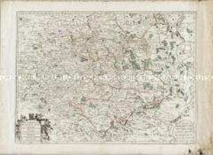
Le Cercle de la Haute Saxe
"Le Cercle de la Haute Saxe"
Le Cercle de la Haute Saxe
Le Cercle De La Haute-Saxe.
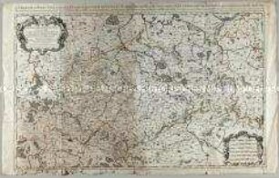
Partie Meridionale du Cercle de Haute Saxe
Partie Meridionale du Cercle de Haute Saxe
Partie Méridionale du Cercle de Haute Saxe

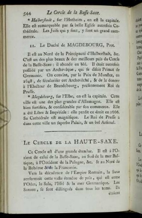
Article XIII. Du Cercle De La Haute-Saxe
Karte des Konsisturiums Wittenberg, ca. 1:510 000, Kupferstich, 1759 : Le Consistoire et Environs De Wittenberg dans la Haute-Saxe. - [Ca. 1:510 000]. - [Paris] : [LeRouge] , [1759]. - 1 Kt. : Kupferst. ; 27 x 20 cm
Wittenberg et Graefenhaynichen Bailliages de la Haute Saxe par Le Rouge
Konsistorium Wittenberg. "Carte du Consistoire Wittenberg, avec les Dioceses et Paroisses ..."
Cercle Meridional de la Haute Saxe
Le Cercle de la Haute Saxe
"Le Cercle de la Haute Saxe"
Le Cercle de la Haute Saxe
Le Cercle De La Haute-Saxe.
Partie Meridionale du Cercle de Haute Saxe
Partie Meridionale du Cercle de Haute Saxe
Partie Méridionale du Cercle de Haute Saxe