- Location
-
Leibniz-Institut für Länderkunde e.V., Leipzig
- Collection
-
Collection Alphons Stübel
- Other number(s)
-
HK 1567 (Signatur)
- Material/Technique
-
kolor.
- Inscription/Labeling
-
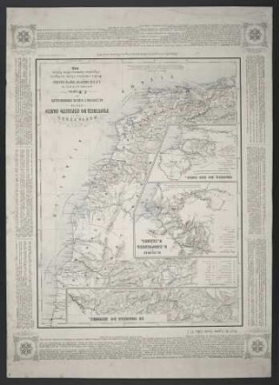
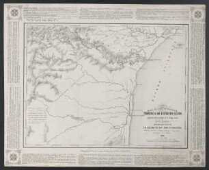
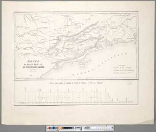
Maßstab in graph. Form (Braças, Metros). - Titel und Maßstab oben rechts. - Mit Grundstücknummerierung. - W oben. - Mit 8 Nebenkt.: Povoação Badenfurt. Freguezia de S. Pedro Apostolo. Povoação Aquidabán. Povoação Ascurra. Mappa do Rio Jtajahy. Povoação Cariós com Indayál. Povoação Warnow. Povoação Blumenau & Ponta Aguda (Scharfeneck). - Ohne Relief
- Subject (what)
-
Altkarte
Katasterplan
Brasilien
Blumenau
- Event
-
Veröffentlichung
- (who)
-
Bernardo Scheidemantel (Verlag)
- (where)
-
Blumenau
- (when)
-
1872
- Rights
-
Leibniz-Institut für Länderkunde e.V.
- Last update
-
16.11.2025, 11:43 AM CET
Data provider
This object is provided by:
Leibniz-Institut für Länderkunde e. V.. If you have any questions about the object, please contact the data provider.
Leibniz-Institut für Länderkunde e. V.. If you have any questions about the object, please contact the data provider.
Object type
- Karte
Associated
- Bernardo Scheidemantel (Verlag)
Time of origin
- 1872
Other Objects (12)

Mappa Cearl Da Colonia Blumenau
Mappa Geral da Provincia Do Espirito-Santo relativo As Colonias E Vias De Communiçacão

Mappa Geral Das Colonias De S. Leopoldina S. Izabel E Rio Novo na Provincia Do Espirito Santo
Mappa Geral Da Provincia Do Paraná : com os Caminhos de ferro estudados e projectados
Mappa colonias Milesiorum
Mappa da Colonia Dona Francisca
Mappa Das Colonias Do Mucury
Mappa Da Parte Septentrional da Provincia Do Espirito-Santo
Mappa Da Região Principal Da Provincia De S. Paulo
Biblioteca Geral

Mappa de parte da Provincia De Santa Catharina : Servindo para indicar os diversos pontos onde se achão collocadas as diversas Colonias

Dicionário de língua geral amazônica : 1ª parte: Português–Língua Geral - 2ª parte: Língua Geral–Português
Mappa Cearl Da Colonia Blumenau
Mappa Geral da Provincia Do Espirito-Santo relativo As Colonias E Vias De Communiçacão
Mappa Geral Das Colonias De S. Leopoldina S. Izabel E Rio Novo na Provincia Do Espirito Santo
Mappa Geral Da Provincia Do Paraná : com os Caminhos de ferro estudados e projectados
Mappa colonias Milesiorum
Mappa da Colonia Dona Francisca
Mappa Das Colonias Do Mucury
Mappa Da Parte Septentrional da Provincia Do Espirito-Santo
Mappa Da Região Principal Da Provincia De S. Paulo
Biblioteca Geral
Mappa de parte da Provincia De Santa Catharina : Servindo para indicar os diversos pontos onde se achão collocadas as diversas Colonias