Karte / Plan
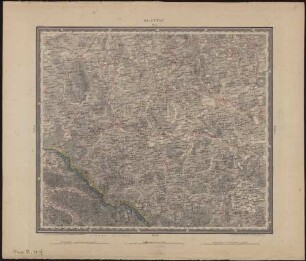
Topographisch-militärische Charte von Teutschland in 204 Sectionen, unternommen von dem Geographischen Institute zu Weimar 1807. Section 123. Teil von Böhmen [Pilsen-Klattau].
- Former reference number
-
C IX no. 28
- Dimensions
-
Maßstab: [1 : 185.000]
- Context
-
RW Karten >> 1. Topographische Karten >> 1.2. Kartenwerke und Spezialkarten >> 1.2.1. Deutschland und Europa
- Holding
-
RW Karten
- Date of creation
-
[1807]
- Other object pages
- Provenance
-
Diverse Registraturbildner
- Delivered via
- Last update
-
17.09.2025, 3:23 PM CEST
Data provider
This object is provided by:
Landesarchiv Nordrhein-Westfalen. Abteilung Rheinland. If you have any questions about the object, please contact the data provider.
Landesarchiv Nordrhein-Westfalen. Abteilung Rheinland. If you have any questions about the object, please contact the data provider.
Object type
- Karten / Pläne
Time of origin
- [1807]
Other Objects (12)
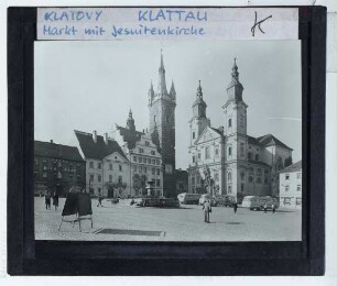
Klattau, Jesuitenkirche,Klattau, Rathaus

Gemeindevermisstenliste: Protekorat; Budweis; Jiltschin; Kladno; Klattau; Königsgrätz; Kolin; Pardubitz; Pilsen
Topographisch-militairische Charte von Teutschland ; in 204 Sectionen unternommen von dem Geographischen Institute zu Weimar
Topographisch-militärische Charte von Teuschland in 204 Sectionen unternommen von dem Geographischen Institute zu Weimar.

Klattau
Klattau

Topographisch-militairische Charte von Teutschland, 4. Band ; in 204 Sectionen unternommen von dem Geographischen Institute zu Weimar
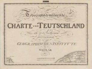
Topographisch-militairische Charte von Teutschland, 1. Band ; in 204 Sectionen unternommen von dem Geographischen Institute zu Weimar
Topographisch-militairische Charte von Teutschland, 3. Band ; in 204 Sectionen unternommen von dem Geographischen Institute zu Weimar
Topographisch-militairische Charte von Teutschland, 2. Band ; in 204 Sectionen unternommen von dem Geographischen Institute zu Weimar
. Atlas der deutschen Bundesstaaten: Karte der böhmischen Kreise Ellbogen, Klattau, Pilsen und Saaz
Panoramapostkarte von Klattau
Klattau, Jesuitenkirche,Klattau, Rathaus
Gemeindevermisstenliste: Protekorat; Budweis; Jiltschin; Kladno; Klattau; Königsgrätz; Kolin; Pardubitz; Pilsen
Topographisch-militairische Charte von Teutschland ; in 204 Sectionen unternommen von dem Geographischen Institute zu Weimar
Topographisch-militärische Charte von Teuschland in 204 Sectionen unternommen von dem Geographischen Institute zu Weimar.
Klattau
Klattau
Topographisch-militairische Charte von Teutschland, 4. Band ; in 204 Sectionen unternommen von dem Geographischen Institute zu Weimar
Topographisch-militairische Charte von Teutschland, 1. Band ; in 204 Sectionen unternommen von dem Geographischen Institute zu Weimar
Topographisch-militairische Charte von Teutschland, 3. Band ; in 204 Sectionen unternommen von dem Geographischen Institute zu Weimar
Topographisch-militairische Charte von Teutschland, 2. Band ; in 204 Sectionen unternommen von dem Geographischen Institute zu Weimar
. Atlas der deutschen Bundesstaaten: Karte der böhmischen Kreise Ellbogen, Klattau, Pilsen und Saaz