- Weitere Titel
-
Unterfranken und Aschaffenburg des Königreichs Bayern
- Standort
-
München, Bayerische Staatsbibliothek -- Mapp. XI,91 vl-7
- Maße
-
59 x 53 cm, gefaltet
- Umfang
-
1 Kt.
- Ausgabe
-
Neue revidirte Ausg. Nach amtl. Quellen berichtigt u. ergänzt v. F. Minsinger
- Sprache
-
Deutsch
- Anmerkungen
-
Lithographie
Mit 2 Stadtpl.: Plan von Aschaffenburg mit Umgebung. Plan von Würzburg mit Umgebung. - Maßstab in graph. Form (Geographische auch Baierische Post- und Chaussee-Stunden). - Nebensacht.: Unterfranken und Aschaffenburg des Königreichs Bayern
- Schlagwort
-
Karte
Regierungsbezirk Unterfranken
- Ereignis
-
Veröffentlichung
- (wo)
-
Regensburg
- (wer)
-
Coppenrath
- (wann)
-
[1880]
- Beteiligte Personen und Organisationen
- URN
-
urn:nbn:de:bvb:12-bsb00010894-5
- Letzte Aktualisierung
-
16.04.2025, 08:41 MESZ
Datenpartner
Dieses Objekt wird bereitgestellt von:
Bayerische Staatsbibliothek. Bei Fragen zum Objekt wenden Sie sich bitte an den Datenpartner.
Bayerische Staatsbibliothek. Bei Fragen zum Objekt wenden Sie sich bitte an den Datenpartner.
Beteiligte
- Hammer, C. F.
- Minsinger, Franz
- Coppenrath
Entstanden
- [1880]
Ähnliche Objekte (12)
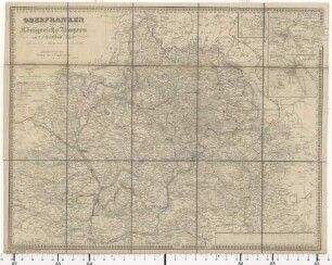
Hammer's Specialkarte des Kreises Oberfranken
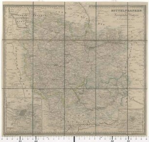
Hammer's Specialkarte des Kreises Mittelfranken
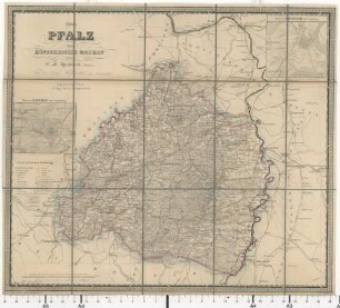
Hammer's Specialkarte des Kreises Pfalz
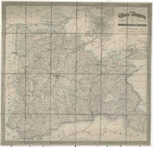
Hammer's Specialkarte des Kreises Ober-Bayern
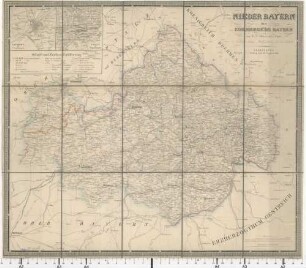
Hammer's Specialkarte des Kreises Nieder-Bayern
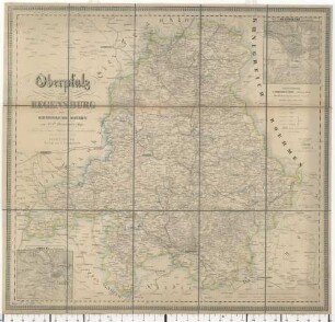
Hammer's Specialkarte des Kreises Oberpfalz und Regensburg
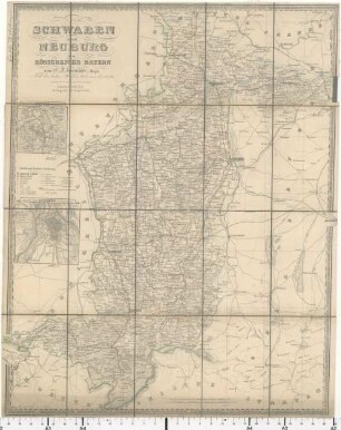
Hammer's Specialkarte des Kreises Schwaben und Neuburg

Meine schönste Weihnachtsgeschichte : von Jung und Alt für Alt und Jung
Windvögel : Drachen bauen kinderleicht
Mein kleines Bestimmungsbuch Bäume
Fremde Impulse - Baudenkmale im Ruhrgebiet, [Buch]. / [Autoren der Objekttexte: David Gropp ...]
Meine liebsten Kinderhits
Hammer's Specialkarte des Kreises Oberfranken
Hammer's Specialkarte des Kreises Mittelfranken
Hammer's Specialkarte des Kreises Pfalz
Hammer's Specialkarte des Kreises Ober-Bayern
Hammer's Specialkarte des Kreises Nieder-Bayern
Hammer's Specialkarte des Kreises Oberpfalz und Regensburg
Hammer's Specialkarte des Kreises Schwaben und Neuburg
Meine schönste Weihnachtsgeschichte : von Jung und Alt für Alt und Jung
Windvögel : Drachen bauen kinderleicht
Mein kleines Bestimmungsbuch Bäume
Fremde Impulse - Baudenkmale im Ruhrgebiet, [Buch]. / [Autoren der Objekttexte: David Gropp ...]