- Alternativer Titel
-
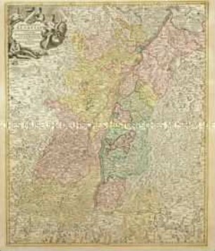
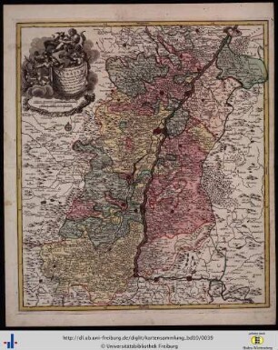
SUPERIORIS Atque INFERIORIS / ALSATIAE / Tabula Perquam Accurata et / Exacta; Proximis Regionib.
- Standort
-
Deutsches Historisches Museum, Berlin
- Inventarnummer
-
Do 2006/634
- Maße
-
Höhe x Breite: 67,5 x 57,5 cm (Blatt)
Höhe x Breite: 53 x 46,3 cm (Karte)
Höhe x Breite: 56 x 49,5 cm (Platte)
- Material/Technik
-
Papier, Kupferstich, grenzkoloriert
- Klassifikation
-
Kartografie (Gattung)
- Bezug (was)
-
Elsass
- Ereignis
-
Herstellung
- (wer)
-
Stecher, Verleger, Geograph: Tobias Konrad Lotter
- (wo)
-
Augsburg, Deutschland
- (wann)
-
1760
- Rechteinformation
-
Deutsches Historisches Museum
- Letzte Aktualisierung
- 24.03.2023, 09:28 MEZ
Datenpartner
Dieses Objekt wird bereitgestellt von:
Stiftung Deutsches Historisches Museum. Bei Fragen zum Objekt wenden Sie sich bitte an den Datenpartner.
Stiftung Deutsches Historisches Museum. Bei Fragen zum Objekt wenden Sie sich bitte an den Datenpartner.
Objekttyp
- Regionalkarte
Beteiligte
- Stecher, Verleger, Geograph: Tobias Konrad Lotter
Entstanden
- 1760
Ähnliche Objekte (12)
Landgraviatus Alsatiae
Mappa Electoratus et Ducatus Bavariae Superioris et Inferioris
Alsatia tam Superioris quam inferioris una cum Sundgovia
Totius Alsatiae Novissima Tabula

Superioris atque inferioris Alsatiae
Superioris atque inferioris Alsatiae.

Lusatiae Inferioris
Lusatiae Superioris
Saxoniae Superioris
Circulus Saxoniae Superioris
Archiducatus Austriae Inferioris accuratissima tabula
Alsatiae Superioris Et Inferioris accuratissima Geographica Descriptio
Landgraviatus Alsatiae
Mappa Electoratus et Ducatus Bavariae Superioris et Inferioris
Alsatia tam Superioris quam inferioris una cum Sundgovia
Totius Alsatiae Novissima Tabula
Superioris atque inferioris Alsatiae
Superioris atque inferioris Alsatiae.
Lusatiae Inferioris
Lusatiae Superioris
Saxoniae Superioris
Circulus Saxoniae Superioris
Archiducatus Austriae Inferioris accuratissima tabula