- Alternativer Titel
-
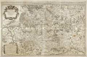
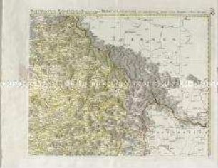
CIRCULUS/ SAXONIAE SUPERIORIS/ in quo/ DUCATUS & ELECTORATUS SAXONIAE/ MARCHIONATUS MISNIAE/ et/ LANDGRAVIATUS THURINGIAE/ cum infertis et finitimis Regionibus exhibentur/ à/ IOHANNE BAPTISTA HOMANNO/ Norimbergae
- Standort
-
Deutsches Historisches Museum, Berlin
- Inventarnummer
-
Do 2002/166
- Maße
-
Höhe x Breite: 56,4 x 63,1 cm (Blatt), Höhe x Breite: 49,1 x 57,2 cm (Platte)
- Material/Technik
-
Papier, Kupferstich, koloriert
- Klassifikation
-
Kartografie (Gattung)
- Bezug (was)
-
Sachsen
Meißen
Thüringen
- Ereignis
-
Herstellung
- (wer)
-
Kartograf: Johann Baptist Homann
- (wo)
-
Nürnberg [historisch: Norimbergae], Deutschland [historisch: Heiliges Römisches Reich]
- (wann)
-
um 1700
- Rechteinformation
-
Deutsches Historisches Museum
- Letzte Aktualisierung
- 24.03.2023, 09:29 MEZ
Datenpartner
Dieses Objekt wird bereitgestellt von:
Stiftung Deutsches Historisches Museum. Bei Fragen zum Objekt wenden Sie sich bitte an den Datenpartner.
Stiftung Deutsches Historisches Museum. Bei Fragen zum Objekt wenden Sie sich bitte an den Datenpartner.
Objekttyp
- Regionalkarte
Beteiligte
- Kartograf: Johann Baptist Homann
Entstanden
- um 1700
Ähnliche Objekte (12)

Saxoniae Superioris
Circulus Franconiae
Circulus Suevicus
Circulus Suevicus
Lusatiae Superioris
Regni Bohemiae Circulus Boleslaviensis ex Müllerianis...
Superioris Atque Inferioris Alsatiae
Circuli Supe. Saxoniae
Circuli Supe. Saxoniae
Mappa Electoratus et Ducatus Bavariae Superioris et Inferioris
Alsatia tam Superioris quam inferioris una cum Sundgovia
Saxoniae, Misniae, Thuringiae ... descriptio
Saxoniae Superioris
Circulus Franconiae
Circulus Suevicus
Circulus Suevicus
Lusatiae Superioris
Regni Bohemiae Circulus Boleslaviensis ex Müllerianis...
Superioris Atque Inferioris Alsatiae
Circuli Supe. Saxoniae
Circuli Supe. Saxoniae
Mappa Electoratus et Ducatus Bavariae Superioris et Inferioris
Alsatia tam Superioris quam inferioris una cum Sundgovia