- Reference number
-
D 30/KE 47/2-2a
- Former reference number
-
prefix: D 30/KE
- Dimensions
-
32,8 x 44,6 cm
- Formal description
-
N: Am kleinen Ämmerle / S: Ammergasse / W: Salzstadelgasse - Urbangasse / O: Schmiedtorstraße
- Material
-
Pergamentpapier und Papier
- Further information
-
Ausführung: Tuschezeichnung und Lichtpause
Maßstab: 1:500
Druck / Verlag: Schmidt, Erich, Dr
- Context
-
D 30 Karten- und Plansammlung >> Öffentliche Gebäude >> Jakobuskirche
- Holding
-
D 30 Karten- und Plansammlung
- Indexbegriff subject
-
Jakobuskirche
- Date of creation
-
1953
- Other object pages
- Last update
-
29.04.2025, 8:35 AM CEST
Data provider
This object is provided by:
Stadtarchiv Tübingen. If you have any questions about the object, please contact the data provider.
Stadtarchiv Tübingen. If you have any questions about the object, please contact the data provider.
Object type
- Karte und Plan
Time of origin
- 1953
Other Objects (12)

Jakobuskirche; Bohrungen im Baugrund
Vorschaltanlage Baugrund-Bohrung
Vorschaltanlage Baugrund-Bohrung
Vorschaltanlage Baugrund-Bohrung
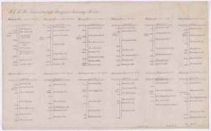
Vorschaltanlage Baugrund-Bohrung
Tübinger Jakobuskirche
Jakobuskirche; Grundriß
Tübinger Jakobuskirche
Jakobuskirche; Sakramentsnischen
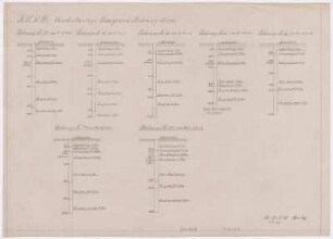
![Vorschaltanlage Baugrund-Bohrung [Längsprofile]](https://iiif.deutsche-digitale-bibliothek.de/image/2/45b5004e-4181-4997-82b4-a87013d1f293/full/!306,450/0/default.jpg)
Vorschaltanlage Baugrund-Bohrung [Längsprofile]
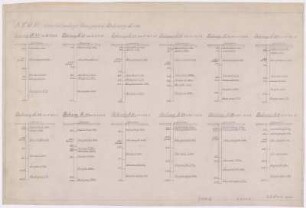
![Vorschaltanlage Baugrund-Bohrung [Längsprofile]](https://iiif.deutsche-digitale-bibliothek.de/image/2/fd272e5e-6652-41c9-933c-1f9185760548/full/!306,450/0/default.jpg)
Vorschaltanlage Baugrund-Bohrung [Längsprofile]
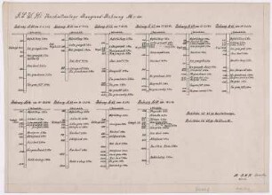
![Vorschaltanlage Baugrund-Bohrung [Längsprofile]](https://iiif.deutsche-digitale-bibliothek.de/image/2/ae1f89b9-0239-42a3-9e34-59a261457aec/full/!306,450/0/default.jpg)
Vorschaltanlage Baugrund-Bohrung [Längsprofile]
Jakobuskirche; Bohrungen im Baugrund
Vorschaltanlage Baugrund-Bohrung
Vorschaltanlage Baugrund-Bohrung
Vorschaltanlage Baugrund-Bohrung
Vorschaltanlage Baugrund-Bohrung
Tübinger Jakobuskirche
Jakobuskirche; Grundriß
Tübinger Jakobuskirche
Jakobuskirche; Sakramentsnischen
Vorschaltanlage Baugrund-Bohrung [Längsprofile]
Vorschaltanlage Baugrund-Bohrung [Längsprofile]
Vorschaltanlage Baugrund-Bohrung [Längsprofile]
Jakobuskirche; Bohrungen im Baugrund
Vorschaltanlage Baugrund-Bohrung
Vorschaltanlage Baugrund-Bohrung
Vorschaltanlage Baugrund-Bohrung
Vorschaltanlage Baugrund-Bohrung
Tübinger Jakobuskirche
Jakobuskirche; Grundriß
Tübinger Jakobuskirche
Jakobuskirche; Sakramentsnischen
Vorschaltanlage Baugrund-Bohrung [Längsprofile]
Vorschaltanlage Baugrund-Bohrung [Längsprofile]